2025 September LIP of the Month
Four-layer tuff marker horizon in North China black shales as the first rock-based precise natural chronostratigraphic boundary in the pre-Ediacaran geological timescale*
Shuan-Hong Zhang1,2,*, Sandra L. Kamo3, Richard E. Ernst4, Jun-Ling Pei2,5, Guo-Hui Hu1,2, Qi-Qi Zhang1,2, Hafida El Bilali4, Yue Zhao1,2
1. State Key Laboratory of Deep Earth and Mineral Exploration, Institute of Geomechanics, Chinese Academy of Geological Sciences, Beijing 100081, China
2. MNR Key Laboratory of Paleomagnetism and Tectonic Reconstruction, Beijing 100081, China
3. Jack Satterly Geochronology Laboratory, Department of Earth Sciences, University of Toronto, Toronto, Ontario M5S 3B1, Canada
4. Department of Earth Sciences, Carleton University, Ottawa, Ontario K1S 5B6, Canada
5. School of Earth Sciences, East China University of Technology, Nanchang, Jiangxi 330013, China
E-mail: tozhangshuanhong@163.com (Dr. S.-H. Zhang)
* This report is extracted and modified from the following paper; full details are available in the published article:
Zhang, S.-H., Kamo, S.L., Ernst, R.E., Pei, J.-L., Hu, G.-H., Zhang, Q.-Q., El Bilali, H., Zhao, Y., 2025. 1.38 Ga four-layer tuff marker horizon in North China black shales as a chronostratigraphic boundary for the pre-Ediacaran geological timescale. Geophysical Research Letters. 52, e2025GL117200. DOI: 10.1029/2025GL117200.
Abstract
Boundaries in the Phanerozoic chronostratigraphic scale are mainly precisely defined and dated, and many correspond to environmental catastrophes induced by the emplacement of LIPs. However, subdivisions of the pre-Ediacaran timescale are currently defined by assigned approximate absolute ages without regard to a type section with precise age constraints. Here we identified a unique four-layer tuff sequence within the Xiamaling Formation black shales, North China Craton, that can be traced over a large area ~400 km long by ~100 km wide, and represents a synchronous marker horizon formed by air fall tuffs from distant volcanic eruptions. High-precision U-Pb geochronology shows that the tuff sequence span a short duration of 0.21 Myr at 1380.41±0.99 Ma. The tuff layers match the age of widely distributed ~1380 Ma LIPs found on multiple cratons in the Columbia/Nuna supercontinent. Based on climate circulation models, the specific inferred source for the tuff sequence is the Mashak LIP in Baltica. We suggest that the four-layer tuff marker horizon represents a unique chronostratigraphic marker and type section for the Calymmian/Ectasian boundary at 1380.41±1.20 Ma.
1. Introduction
The Geologic Time Scale (GTS) is the framework for deciphering and understanding the evolutionary history of planet Earth (e.g., Gradstein et al., 2020). Boundaries of the GTS are marked by significant geological and biological events. Phanerozoic and Ediacaran geological timescale boundaries are defined by basal, rock-based Global Stratotype Section and Points (GSSPs). Some GSSPs correspond to environmental catastrophes induced by global events such as the emplacement of Large Igneous Provinces (LIPs). However, pre-Ediacaran timescale boundaries are assigned absolute ages usually to the nearest 50 or 100 Myrs due to a lack of criteria for correlation, such as fossils and non-biological proxies (Gradstein & Ogg, 2020; Strachan et al., 2020; Shields et al., 2022; Happer, 2024).Global geological events represented by LIPs and their climatic expression in the sedimentary record can potentially define boundaries in the Precambrian GTS (Ernst & Youbi, 2017; Ernst et al., 2020, 2021; Zhang et al., 2018, 2024a). However, until now no type section and precise marker horizon has been proposed for the pre-Ediacaran timescale boundary.
Oceanic anoxic events, represented by deposition of large volumes of marine black shales, coeval LIPs and associated mass extinction events, are temporally correlated with some geological boundaries in the Phanerozoic international chronostratigraphic timescale (e.g., Percival et al., 2015, 2016). Volcanic ash/tuff layers are common in many GSSPs (e.g., Yin et al., 1992; Shen at al., 2012; Schmitz & Davydov, 2012), and are ideal since they can be correlated based on age in any facies regardless of paleoclimate, paleoceanography, geochemistry and paleogeography (Davydov et al., 2020). LIPs have also been implicated in the formation of black shales. Recent studies have suggested that weathering of LIPscan lead to increased input of nutrients into oceans and cause enhanced oceanic productivity and organic carbon burial leading to black shale deposits (e.g., Erba et al., 2004; Percival et al., 2015, 2016; Zhang et al., 2024b; Wang et al., 2025).
LIPs are common during the 'Boring Billion' (1800–800 Ma) in the mid-Proterozoic(Ernst, 2014; Ernst et al., 2021). Areally extensive thick black shale deposits are well developed in many intracratonic or rift basins during this period, indicating significant accumulations and burial of organic carbon (Zhang et al., 2021). Previous studies have shown a spatiotemporal and possible causal link between LIPs and large volume black shale deposits across different cratons, particularly at ~1640 Ma, ~1380 Ma and ~1100 Ma (Zhang et al., 2018, 2021, 2024a).
Black shales (~1.381.36 Ga) within the Xiamaling Formation, Yanliao Basin, in the North China Craton (NCC), are 50–200 m thick and the present day preserved outcrops of black shales extend over a large area approximately 500 km long by 100 km wide (Figure 1). Volcanic ash/tuff layers are common within black shales of the Xiamaling Formation in the NCC (Gao et al., 2007, 2008a, 2008b; Su et al., 2008, 2010). Previous U-Pb zircon dating by SHRIMP on 10 tuff samples yielded crystallization ages ranging from 1380±36 Ma to 1366±9 Ma with large 2 errors of 44–9 Myr (Gao et al., 2007, 2008a, 2008b; Su et al., 2008, 2010), and U-Pb zircon dating by ID-TIMS yielded a crystallization age of 1384.4±1.4 Ma (Zhang et al., 2015).
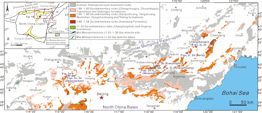
Figure 1 Geological map showing distribution of the Xiamaling Formation in the Yanliao Basin in the northern NCC and locations of four-layer tuff marker horizon and sample sections (modified after Zhang et al., 2017).
A remarkable, distinctive set of four tuff layers, each 3–5 cm thick and spanning a stratigraphic thickness of 0.71.0 m, has been identified from the middle part of the Xiamaling Formation black shale sequence and represents a unique marker horizon that can be traced over an area approximately 100 km wide and extending ~400 km long from Xiahuayuan in the west to Lingyuanin the east (Figures 1 and 2). Similar geometry (Figures 2) indicates that the four-layer tuff sequence represents a synchronous surface, which provides an important marker horizon within the Xiamaling Formation. The regional extent of the four-layer tuff marker horizon signifies the high intensity of the explosive volcanic eruptions during deposition of the Xiamaling Formation black shales.
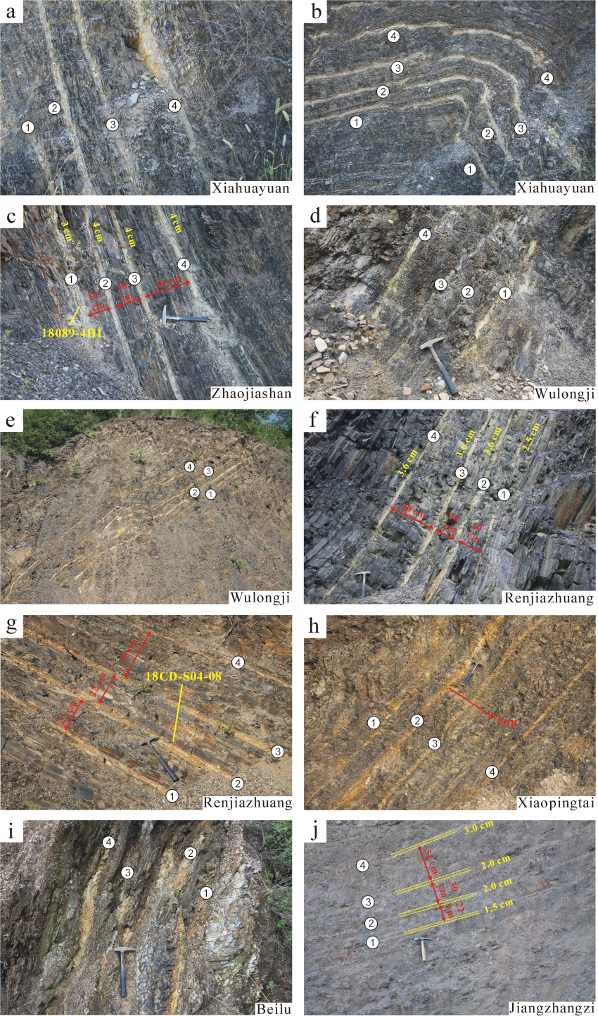
Figure 2 Field photographs showing the four-layer tuff marker horizon within black shales of the Xiamaling Formation.
Our recent study focuses on the ~13801360 Ma black shales in the Yanliao Basin (NCC) that contains this special four-layer tuff marker horizon. We present new high-precision U-Pb CA-ID-TIMS zircon ages from ash beds within and above the four-layer tuff sequence collected over a distance of approximately 330 km. The new ages establish the precise timing and duration of the four-layer tuff sequence and permit global correlations with coeval LIPs that allow us to propose a unique chronostratigraphic marker for the Calymmian/Ectasian boundary in the mid-Proterozoic.
2. U-Pb CA-ID-TIMS age constraints on the special four-layer tuff horizon within black shales of the Xiamaling Formation
Our new U-Pb CA-ID-TIMS results for samples 18089-4HL and 18CD-S04-08 collected from the first (lowermost) layer within the special four-layer tuff horizon in the Zhaojiashan scetion (Figure 2c) and the second lowermost layer from the Renjiazhuang section (Figure 2g), approximately 250 km to the east (Figure 1), yield crystallization ages of 1380.4±1.1 Ma and 1380.3±2.1 Ma, respectively (Zhang et al., 2025). The two ages are consistent with their relative sedimentary positions, but overlap within their stated uncertainties, and indicate that the four-layer tuff horizon is a result of an intensive volcanic eruption during deposition of the black shales of the Xiamaling Formation at ~1380 Ma. The weighted mean 207Pb/206Pb age of 11 zircon grains from the above two samples is 1380.41±0.99 Ma, which we consider the best age estimate for deposition of the special four-layer tuff horizon within black shales of the Xiamaling Formation in the Yanliao Basin.
3. Sedimentation rate for black shale deposition and its constraints on age span of the four-layer tuff marker horizon
The four-layer tuff marker horizon is distributed over an area ~400 km long and ~100 km wide from west to east within black shales of the Xiamaling Formation (Figure 1), represents a period of the most intensive volcanic eruptions that occurred during deposition of the Xiamaling Formation. A precise age span for the four-layer tuff marker horizon is important to constrain the duration of intensive volcanic eruptions during deposition of the Xiamaling Formation. Using the best estimated age of 1380.41±0.99 Ma for the four-layer tuff bed and the U-Pb CA-ID-TIMS ages of 1377.0±1.3 Ma and 1367.3±1.5 Ma from tuff beds 12 m and 51 m above the four-layer tuff horizon (Zhang et al., 2025), respectively, two sedimentation rates of 3.52 m/Myr and 3.89 m/Myr are obtained from the Beilu and Zhaojiashan sections, respectively. Because these two sections are located in different parts of the Yanliao Basin, about 330 km apart (Figure 1), the similarity in the calculated sedimentation rates suggests no significant difference between the sedimentation rates of black shales in different parts of the Yanliao Basin.
By using the sedimentation rate of 3.89 m/Myr for black shales in the Zhaojiashan section and the cumulative thickness of 81 cm for the four-layer tuff horizon and interlayered black shales in the same section, a duration of approximately 0.21 Myr can be calculated for the four-layer tuff horizon within black shales of the Xiamaling Formation. Therefore, the intensive volcanic eruptions as recorded in the four-layer tuff marker horizon within black shales during deposition of the Xiamaling Formation occurred during a short period of ~0.21 Myr at 1380.41±0.99 Ma.
4. Relation between ~1380 Ma intensive volcanic eruptions and LIPs in the Columbia/Nuna supercontinent
Although tuffaceous ash beds with zircon U-Pb ages ranging from 1390 Ma to 1360 Ma (including the distinctive four-layer tuff marker horizon) are common in the Xiamaling Formation of the NCC, there is no other indication of magmatic activity of this age in the NCC (e.g., Peng, 2015; Zhang & Zhao, 2016). The source of these tuffaceous ash beds and ancient volcanic eruptions must therefore be located on other crustal blocks formerly adjacent to the NCC. Our field investigations show that both the numbers and thicknesses of tuffaceous ash beds (including the four-layer tuff marker horizon) within the Xiamaling Formation exhibit a decreasing trend from west to east in the Yanliao Basin (Figure 1), suggesting a source to the west of the northern NCC (in present-day coordinates) (Figure 3a). Another constraint is the apparent absence of tuffaceous ash beds or K-bentonite beds in the formerly attached (Zhang et al., 2017) and coeval ~13801360 Ma Velkerri and Kyalla black shales in the Greater McArthur Basin in the North Australian Craton (NAC) (Munson & Revie, 2018), suggesting that the NAC was most likely further from the source areas than the NCC.

Figure 3 Paleogeographic reconstruction map (a) of Columbia supercontinent at 1400 Ma (modified after Zhang et al., 2022) showing possible relation between global-scale ~1.38 Ga LIPs and intensive volcanic eruptions recorded with the Xiamaling Formation black shales in the NCC (shown with a yellow color) and their possible source areas. Inset maps (b) and (c) show the concept model for transporting ashes of Mashak LIP in Baltica to the Yanliao Basin in the NCC and the idealized atmospheric circulation model of the present-day Earth (modified after Murck et al., 1997), respectively.
In the paleogeographic reconstruction of the Columbia/Nuna supercontinent at ~1400 Ma(Figure 3a), the western-northern margin of the NCC is a near neighbor to western-northern Siberia, eastern Baltica and northern Greenland each of which has associated ~1380 Ma LIPs (Ernst et al., 2021) (Figure 3a). Any or all of these LIPs may serve as the source area of tuffaceous ash beds in the NCC. It should be noted that LIP units of this ~1380 Ma age are also common on other continental blocks including North America, West Australia, Kalahari, Amazonia, West Africa and Congo (Figure 3a). The extensive distribution of ~1380 MaLIPs and black shales across different cratons suggest a causal link among them as previously suggested (Zhang et al., 2018).
The temporal/spatial distributions of tuffaceous ash beds within black shales of the Xiamaling Formation, combined with the paleogeographic reconstruction map of Columbia supercontinent at 1400 Ma and lack of tuff beds in the ~13801360 Ma black shales of the Velkerri and Kyalla formations of the Greater McArthur Basin in the NAC show that intermediate-felsic magmatism of the ~1380 Ma Mashak LIP in eastern Baltica is most likely the source area of the tuffaceous ash beds within the Xiamaling Formation in the NCC. Furthermore, Hadley atmospheric circulation (e.g., Murck et al., 1997; Lockwood, 2005) is most likely the main driving force for long distance (about 4000 km as shown in Figure 3ab) transport of volcanic ash from the Mashak LIP in eastern Baltica to the Yanliao Basin, northern NCC. The Mashak LIP is located near the equator in the paleogeographic reconstruction map of Columbia supercontinent at 1400 Ma (Figure 3a). The equatorial low pressure zone resulted in rising of warm air and upward transport of ash from the Mashak LIP to high attitude followed by circulation in a northeast direction (Figure 3ac). In contrast, the Yanliao Basin in the northern NCC is located in the subtropical high pressure zone near 30°N, which is marked by descending cool and dry air (e.g., Murck et al., 1997). Therefore, when the ash from the Mashak LIP is transported northeast to the subtropical high pressure zone, it will move downward with descending cool and dry air and be deposited in the Yanliao marine basin of the NCC, within the accumulating Xiamaling Formation (Figure 3b). Our interpretation suggests the existence of the present-day-like Hadley atmospheric circulation as early as ~1380 Ma in the Mesoproterozoic Era.
5. The Calymmian/Ectasian boundary in the mid-Proterozoic: Proposed age and type section
The globally widespread record of ~1380 Ma LIPs has been proposed as a proxy for environmental changes at the Calymmian/Ectasian boundary (Ernst & Youbi, 2017; Ernst et al., 2020, 2021) with an official age of 1400 Ma (Gradstein & Ogg, 2020; Strachan et al., 2020). As mentioned above, the four-layer tuff marker horizon within black shales of the Xiamaling Formation represents a period of the most intensive explosive volcanic eruptions during deposition of the Xiamaling Formation at 1380.41±0.99 Ma and may represent an important boundary in the Mesoproterozoic geological timescale. The temporal association of ~1380 Ma LIP events and these 1380.41±0.99 Ma black shales has suggested that the black shales represent a natural stratigraphic marker for a climatic change associated with the Calymmian/Ectasian boundary (Zhang et al., 2018). We further propose that the distinctive four-layer tuff marker horizon within the Xiamaling Formation black shales represents a specific chronostratigraphic marker located in the Yanliao Basin in the NCC for the Calymmian/Ectasian boundary in the international chronostratigraphic scale. Our U-Pb CA-ID-TIMS age constraints on the four-layer tuff marker horizon of 1380.41±0.99 Ma and its short duration of 0.21 Myr can provide a precise age for the Calymmian/Ectasian boundary at 1380.41±1.20 Ma (0.99+0.21 Ma). The Xiamaling Formation in the Yanliao Basin in the northern NCC therefore can provide a unique chronostratigraphic marker for the Calymmian/Ectasian boundary in mid-Proterozoic, which represents the first rock-based precise natural chronostratigraphic boundary and type section in the pre-Ediacaran international chronostratigraphic scale.
6. Summary and conclusions
Our field investigations have identified a unique, regional-scale four-layer tuff marker horizon, with each layer 3–5 cm thick, hosted within black shales of the Xiamaling Formation in the Yanliao Basin, northern NCC. This distinctive four-layer tuff horizon is distributed across an area approximately 400 km long by 100 km wide. It represents the most intensive explosive volcanic eruptions that occurred during deposition of the black shales of the Xiamaling Formation. High-precision U-Pb CA-ID-TIMS zircon dating of the four-layer tuff horizon and tuffaceous ash beds above it, permit estimation of low sedimentation rates for the black shales ranging from 3.52 m/Myr to 3.89 m/Myr. The ages combined with the sedimentation rates show that the volcanic eruptions as recorded in the four-layer tuff beds occurred over a very short time period of ~0.21 Myr at 1380.41±0.99 Ma.
Temporal/spatial distributions in the paleogeographic reconstruction map of Columbia/Nuna supercontinent suggest a causal link between LIPs, black shales and tuffs. The Mashak LIP in Baltica is suggested as the specific source for the four-layer tuff marker horizon. We propose that the four-layer tuff marker horizon, dated at 1380.41±0.99 Ma with an age span of ~0.21 Myr and located within black shales of the Xiamaling Formation in the Yanliao Basin, northern NCC, represents a unique chronostratigraphic marker for the Calymmian/Ectasian boundary at 1380.41±1.20 Ma on the international chronostratigraphic scale. This would constitute the first rock-based, high-precision natural chronostratigraphic boundary and proposed type section for Calymmian/Ectasian transition within the pre-Ediacaran geological timescale.
References
Davydov, V. I. (2020) Shift in the paradigm for GSSP boundary definition. Gondwana Research, 86, 266–286.
Erba, E., Bartolini, A., & Larson, R. L. (2004) Valanginian Weissert oceanic anoxic event. Geology, 32(2), 149–152.
Ernst, R. E. (2014) Large Igneous Provinces. Cambridge University Press, Cambridge, pp. 1–653.
Ernst, R. E., & Youbi, N. (2017) How Large Igneous Provinces affect global climate, sometimes cause mass extinctions, and represent natural markers in the geological record. Palaeogeography, Palaeoclimatology, Palaeoecology, 478, 30–52.
Ernst, R. E., Bond, D. P. G., & Zhang, S. H. (2020) Chapter 12 - Influence of Large Igneous Provinces. In: Gradstein, F. M., Ogg, J. G., Schmitz, M. D., & Ogg, G. M., (Eds.), Geologic Time Scale 2020, Elsevier, v. 1, pp. 345–356.
Ernst, R. E., Bond, D. P. G., Zhang, S. H., Buchan, K. L., Grasby, S. E., Youbi, N., El Bilali, H., Bekker, A., & Doucet, L. S. (2021) Large igneous province record through time and implications for secular environmental changes and geological time-scale boundaries. In: Ernst, R. E., Dickson, A. J., & Bekker, A. (Eds.), Large Igneous Provinces: A Driver of Global Environmental and Biotic Changes. AGU Geophysical Monograph Series (GM 255). American Geophysical Union and John Wiley & Sons, Inc., pp. 3–26.
Gao, L., Zhang, C., Shi, X., Zhou, H., & Wang, Z. (2007) Zircon SHRIMP U-Pb dating of the tuff bed in the Xiamaling Formation of the Qingbaikouan System in North China. Geological Bulletin of China, 26, 249–255 (in Chinese with English abstract).
Gao, L., Zhang, C., Yin, C., Shi, X., Wang, Z., Liu, Y., Liu, P., Tang, F., & Song, B. (2008a) SHRIMP zircon ages: basis for refining the chronostratigraphic classification of the Meso-and Neoproterozoic strata in North China Old Land. Acta Geoscientica Sinica, 29, 366–376 (in Chinese with English abstract).
Gao, L., Zhang, C., Shi, X., Song, B., Wang, Z., & Liu, Y. (2008b) Mesoproterozoic age for Xiamaling Formation in North China Plate indicated by zircon SHRIMP dating. Chinese Science Bulletin, 53, 2665–2671.
Gradstein, F. M. (2020) Chapter 1 – Introduction. In: Gradstein, F. M., Ogg, J. G., Schmitz, M. D., & Ogg, G. M., (Eds.), Geologic Time Scale 2020, Elsevier, v. 1, pp. 1–20.
Gradstein, F. M., & Ogg, J. G.(2020) Chapter 2 - The Chronostratigraphic Scale. In: Gradstein, F. M., Ogg, J. G., Schmitz, M. D., & Ogg, G. M., (Eds.), Geologic Time Scale 2020, Elsevier, v. 1, pp. 21–32.
Lockwood, J. G. (2005) Atmospheric Circulation, Global. In: Oliver, J. E. (Ed.) Encyclopedia of World Climatology. Encyclopedia of Earth Sciences Series. Springer, Dordrecht, pp. 126134.
Munson, T. J., Revie, D. (2018) Stratigraphic subdivision of the Velkerri Formation, Roper Group, McArthur Basin, Northern Territory. Darwin, Northern Territory Geological Survey, Record 2018-006, pp. 1–27.
Murck, B. W., Brian, J. S., & Stephen, C. P. (1997) Dangerous Earth: An Introduction to Geologic Hazards. New York, John Wiley & Sons Inc., pp. 1–300.
Papadomanolaki, N. M., van Helmond, N. A. G. M., Pälike, H., Sluijs, A., & Slomp, C. P. (2022) Quantifying volcanism and organic carbon burial across Oceanic Anoxic Event 2. Geology, 50, 511–515.
Peng, P. (2015). Precambrian mafic dyke swarms in the North China Craton and their geological implications. Science China Earth Sciences, 58, 649–675.
Percival, L. M. E., Witt, M. L. I., Mather, T. A., Hermoso, M., Jenkyns, H. C., Hesselbo, S. P., Al-Suwaidi, A. H., Storm, M. S., Xu, W., & Ruhl, M. (2015) Globally enhanced mercury deposition during the end-Pliensbachian extinction and Toarcian OAE: a link to the Karoo–Ferrar Large Igneous Province. Earth and Planetary Science Letters, 428, 267–280.
Percival, L. M. E., Cohen, A. S., Davies, M. K., Dickson, A. J., Hesselbo, S. P., Jenkyns, H. C., Leng, M. J., Mather, T. A., Storm, M. S., & Xu, W. (2016) Osmium isotope evidence for two pulses of increased continental weathering linked to Early Jurassic volcanism and climate change. Geology, 44, 759–762.
Schmitz, M. D., Davydov, V. I. (2012) Quantitative radiometric and biostratigraphic calibration of the Pennsylvanian–Early Permian (Cisuralian) time scale and pan-Euramerican chronostratigraphic correlation. GSA Bulletin, 124, 549–577.
Shen, J., Algeo, T. J., Hu, Q., Zhang, N., Zhou, L., Xia, W. C., Xie, S. C., & Feng, Q. L. (2012) Negative C-isotope excursions at the Permian–Triassic boundary linked to volcanism. Geology, 40, 963–966.
Shields, G. A., Strachan, R. A., Porter, S. M., Halverson, G. P., Macdonald, F. A., Plumb, K. A., de Alvarenga, C. J., Banerjee, D. M., Bekker, A., Bleeker, W., Brasier, A., Chakraborty, P. P., Collins, A. S., Condie, K., Das, K., Evans, D. A. D., Ernst, R., Fallick, A. E., Frimmel, H., Fuck, R., Hoffman, P. F., Kamber, B. S., Kuznetsov, A. B., Mitchell, R. N., Poiré, D. G., Poulton, S. W., Riding, R., Sharma, M., Storey, C., Stueeken, E., Tostevin, R., Turner, E., Xiao, S. H., Zhang, S. H., Zhou, Y., & Zhu, M. Y. (2022) A template for an improved rock-based subdivision of the pre-Cryogenian timescale. Journal of the Geological Society, 179(1), jgs2020–222.
Strachan, R., Murphy, J. B., Darling, J., Storey, C., & Shields, G. A. (2020) Chapter 16 - Precambrian (4.56–1.0 Ga). In: Gradstein, F. M., Ogg, J. G., Schmitz, M. D. & Ogg, G. M. (Eds.), Geologic Time Scale 2020. Elsevier, v. 1, pp. 481–493.
Su, W., Zhang, S., Huff, W. D., Li, H., Ettensohn, F. R., Chen, X., Yang, H., Han, Y., Song, B., & Santosh, M. (2008) SHRIMP U-Pb ages of K-bentonite beds in the Xiamaling Formation: Implications for revised subdivision of the Meso- to Neoproterozoic history of the North China Craton. Gondwana Research, 14, 543–553.
Su, W., Li, H., Huff, W. D., Ettensohn, F. R., Zhang, S., Zhou, H., & Wan, Y. (2010) SHRIMP U-Pb dating for a K-bentonite bed in the Tieling Formation, North China. Chinese Science Bulletin, 55, 3312–3323.
Wang, X., Yuan, C., Liu, S. A., Ye, Y., Wang, T., & Zhang, S. (2025) Volcanically modulated micronutrient cycles in the mid-Proterozoic ocean. Geology, 53(7), 567571.
Xu, L., Lechte, M., Shi, X., Zheng, W., Zhou, L., Huang, K., Zhou, X., & Tang, D. (2024) Large igneous province emplacement triggered an oxygenation event at ~1.4 Ga: Evidence from mercury and paleo-productivity proxies. Geophysical Research Letters, 51, e2023GL106654.
Yin, H. F., Huang, S. J., Zhang, K. X., Hansen, H. J., Yang, F. Q., Ding, M. H., & Bie, X. (1992) The effects of volcanism on the Permo-Triassic mass extinction in South China. In: Sweet, W. C., Yang, Z. Y., Dickins, J. M., & Yin, H. F. (Eds.), Permo-Triassic Events in the Eastern Tethys: Stratigraphy, Classification, and Relations with the Western Tethys. Cambridge University Press, Cambridge, pp. 146–157.
Zhang, S. C., Wang, X., Hammarlund, E. U., Wang, H., Costa, M. M., Bjerrum, C. J., Connelly, J. N., Zhang, B., Bian, L., & Canfield, D. E. (2015), Orbital forcing of climate 1.4 billion years ago. PNAS, 112, E1406–E1413.
Zhang, S. C., Wang, H. J., Wang, X. M., Zheng, W., Hao, J. H., Pogge von Strandmann, P. A. E., Ye, Y. T., Shi, M., Liu, Y. K., & Lyu, Y. T. (2024b) Subaerial volcanism broke mid-Proterozoic environmental stasis. Science Advances, 10, eadk5991.
Zhang S. H., & Zhao Y. (2016) Magmatic records of the late Paleoproterozoic to Neoproterozoic extension and rifting events in the North China Craton: A preliminary review. In: Zhai, M., Zhao, Y., Zhao, T. (Eds.), Main Tectonic Events and Metallogeny of the North China Craton. Springer Geology, pp. 359–391.
Zhang, S. H., Zhao, Y., Li, X. H., Ernst, R. E., & Yang, Z. Y. (2017) The 1.33–1.30 Ga Yanliao large igneous province in the North China Craton: Implications for reconstruction of the Nuna (Columbia) supercontinent, and specifically with the North Australian Craton. Earth and Planetary Science Letters, 465, 112–125.
Zhang, S. H., Ernst, R. E., Pei, J. L., Zhao, Y., Zhou, M. F., & Hu, G. H. (2018) A temporal and causal link between ca. 1380 Ma large igneous provinces and black shales: Implications for the Mesoproterozoic time-scale and paleoenvironment. Geology, 46, 963–966.
Zhang, S. H., Ernst R. E., Pei, J. L., Zhao, Y., & Hu, G. H. (2021) LIPs (large igneous provinces) and anoxia events in 'the Boring Billion'. In: Ernst, R. E., Dickson, A. J., & Bekker, A. (Eds.), Large Igneous Provinces: A Driver of Global Environmental and Biotic Changes. AGU Geophysical Monograph Series (GM 255). American Geophysical Union and John Wiley & Sons, Inc., pp. 449–486.
Zhang, S. H., Ernst, R. E., Yang, Z. Y., Zhou, Z. Z., Pei, J. L., & Zhao, Y. (2022) Spatial distribution of 1.41.3 Ga LIPs and carbonatite-related REE deposits: evidence for large-scale continental rifting in the Columbia (Nuna) supercontinent. Earth and Planetary Science Letters, 597, 117815.
Zhang, S. H., Kamo, S. L., Ernst, R. E., Hu, G. H., Zhang, Q. Q., El Bilali, H., & Zhao, Y. (2024a). First high-precision U-Pb CA-ID-TIMS age of the Chuanlinggou Formation, North China Craton: Implications for global correlations of black shales and the Statherian/Calymmian boundary. Geophysical Research Letters, 51(18), e2024GL109457
Zhang, S. H., Kamo, S. L., Ernst, R. E., Pei, J. L., Hu, G. H., Zhang, Q. Q., El Bilali, H., & Zhao, Y. (2025) 1.38 Ga four-layer tuff marker horizon in North China black shales as a chronostratigraphic boundary for the pre-Ediacaran geological timescale. Geophysical Research Letters, 52, e2025GL117200.