January 2022 LIP of the Month
Contribution of the Ahmeyim Great Dyke and its satellite mafic dykes of Tasiast-Tijirit Terrane, to understanding Precambrian Large Igneous Provinces of the western Reguibat Shield (Northern Mauritania)
Moussa Hamath Ba1, 2, Nassrddine Youbi2, 4, Khalidou Lo1, Richard E. Ernst5,6, Mohammed Jaffal3, and Hassan Ibouh3
1 Department of Geology, Faculty of Sciences and Technologies, University of Nouakchott Al Aasriya, Mauritania; moussabah85@gmail.com
2 Department of Geology, Faculty of Sciences-Semlalia, Cadi Ayyad University, Prince Moulay Abdellah Boulevard, P.O. Box 2390, Marrakech, 40 000, Morocco
3 Department of Geology, Georessources, Geoenvironment and Civil Engineering (L3G) Laboratory, Faculty of Sciences and Techniques, Cadi Ayyad University, Abdelkarim Al Khattabi Boulevard, P.O. Box 549, Marrakech, 40000, Morocco
4 Departamento de Geologia, Faculdade de Ciências and Instituto Dom Luís, Universidade de Lisboa, Edifício C6, Campo Grande, 1749-016, Lisboa, Portugal
5 Department of Earth Sciences, Carleton University, Ottawa, ON, K1S 5B6, Canada
6 Faculty of Geology and Geography, Tomsk State University, 36 Lenin Ave, Tomsk, 634050, Russia
Extracted and modified from:
Ba, M.H., Ibouh, H., Lo, K., Youbi, N., Jaffal, M., Ernst, R.E., Niang, A.J., Dia, I., Abdeina, E.H., Bensalah, M.K., Boumehdi, M.A., Soderlund, U. (2020a). Spatial and temporal distribution patterns of Precambrian mafic dyke swarms in northern Mauritania (West African craton): analysis and results from remote-sensing interpretation, geographical information systems (GIS), Google Earth ™ images, and regional geology. Arabian Journal of Geosciences, v. 13, 209.
Ba M.H., Jaffal, M., Lo, K., Youbi, N., El Mokhtar Dahmada, M., Ibouh, H., Boumehdi, M.A., Aïfa, T., Amara, M., Jessell, M., Ernst, R.E., Bensalah, M.K., Söderlund, U. (2020b) Mapping mafic dyke swarms, structural features, and hydrothermal alteration zones in Atar, Ahmeyim and Chami areas (Reguibat Shield, Northern Mauritania) using high-resolution aeromagnetic and gamma-ray spectrometry data Journal of African Earth Sciences, v. 163, 103749.
For full details see these papers.
Introduction
Located in the North-West of the Reguibat shield, which is known for its great lithological
and structural diversity, the Archean Terrane of Tasiast-Tijirit is crossed by several generations of mafic dykes (with different of ages, trends, thicknesses and chemical compositions), crosscutting both the granite-gneisses and the supracrustal rocks. These dykes, usually result from periods of extension associated with ascent of large volumes of mantle melts, and are considered vestiges of the Large Igneous Provinces (LIPs) of the Precambrian (e.g., Ernst, 2014 and references therein). They are an essential tool to better retrace the geological events that affected the Archean basement.
The aim of this contribution is to characterize the petrogenesis and geodynamic evolution of mafic dyke swarms of Archean Terrane of Tasiast-Tijirit. This study is based on petrology, geochemical, geophysical and remote sensing from Ba.M.H, 2022 thesis (Ba 2022) and which is published in Ba et al. (2020a, b).
Geological setting of the Reguibat shield
The Reguibat Shield is a ca. 500 by 2,000 km belt of Proterozoic rocks trending southwest to northeast across southern Morocco, northern Mauritania, and southern Algeria. It comprises the northern basement exposure of the West African Craton (WAC) (Fig. 1A). The Reguibat Shield is subdivided into (1) an Archean province in the southwest, that is distinguished from the Proterozoic by high-grade metamorphic rocks (amphibolite and granulite facies) with abundant migmatite and ferruginous quartzites and (2) a Paleoproterozoic province in the center and east, consisting mostly of volcanic and volcano-sedimentary units of Eobirimian and Late Birimian age, and separated by calc-alkaline granitoids of Mesobirimian and Neobirimian magmatic events (Dillon and Sougy 1974; Bessoles 1977; Rocci et al. 1991; Schofield and Gillespie 2007). Now the boundary between the two provinces is marked by a shear zone and the Mdéna fault (Lahondère et al. 2003; Pitfield et al. 2004; Key et al. 2008).
The Archean province (Fig. 1B.) is further subdivided into two Terranes separated by an area of intense ductile shearing, oriented NNE-SSW, and 40 km wide. Terrane collision was dated from the syntectonic granite of the Aoutitilt Suite intruded within the N to NNE Tâçarât–Inemmaûdene Shear Zone: the age of 2.954 Ga for granite corresponds to the maximum timing of transpressive deformation (Pitfield et al., 2004).
The Choum-Rag el Abiod Terrane consists of metamorphic rocks as granulitic facies intersected by major granite bodies and occasionally by metabasic bodies. The Tasiast-Tijirit Terrane Fig. 1C.) consists of migmatitic gneiss, greenstone belts, late granites, and mafic dyke swarms scattered over the granite-gneiss basement. These mafic dyke swarms are preferentially oriented NNE-SSW to NE-SW, NW-SE to WNW-ESE, E-W and N-S.
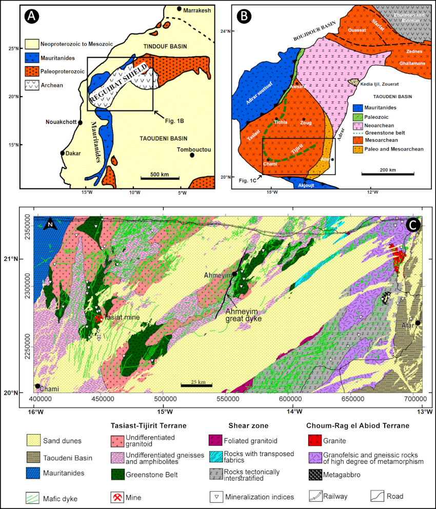
Figure 1: A. Geological sketch map of the West African Craton and location of the Archean province of the Reguibat Shield (modified from Schofield et al., 2012); B. Geological map of the Archean province of the Reguibat Shield (from Schofield et al., 2012) and C. Simplified geological map showing the main lithological units of the study area (modified after Key, 2003; Key and Loughlin, 2003; Key et al., 2003; Pitfield et al., 2004 and Key et al., 2008).
Remote sensing data
The approach uses processed Landsat 8 OLI/TIRS and field observations, allowing mapping of the distribution of the mafic dykes of the Archean of the Reguibat shield (for full details see Ba et al. 2020a). The lineament mapping of the studied area was done manually from visual interpretation of images after various filtering process. This interpretation is followed by drawing lines corresponding to the linear geologic features (fault and dyke) on the different filtered images as well as the color composite image (Fig. 2A). The resulting lineament synthesis map (Fig.2B) comprises a total of 9049 lineaments. The statistical analysis reveals four dyke sets based on trend (Fig. 3, rose diagram).
- The predominant dyke set is oriented NE-SW to NNE-SSW. It represents over 80% of all lineaments extracted from the images by directional and spatial filtering. This set of lineaments is extending over several kilometers and cuts both the granite-gneiss complex and greenstones belt,
- The E-W to ENE-WSW trend represent 9.33% of all the lineaments. It extends over a few tens of kilometers and generally affects the granite and gneiss complex of the entire studied area. This dyke set is better represented in the Amsaga complex (corresponds to the suture zone) where it is intersecting the NE-SW to NNE-SSW trending dykes,
- The NW-SE to WNW-ESE trend represents 9.06% of all the lineaments. It is less visible and it extends over a few kilometers, but the most important dykes can reach hundreds of kilometers in length. Among the most important, is a dyke that stretches over 200 km and intersects the Ahmeyim Great Dyke in the Boû Derga sector,
- The N-S trend is less important than the first three dyke sets. It constitutes 1.3% of all the lineaments and mainly extends over several kilometers. Among the most important, we can mention those outcrops in the Amsaga complex (sheared and mylonitized rocks).
- All the four trending dyke sets are affected in some locations by transverse strike slip faults trending NE-SW.
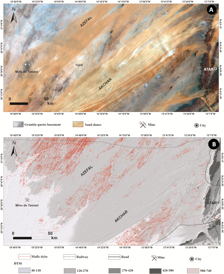
Figure 2: A. Landsat 8 OLI/TIRS satellite image in color composite image of bands number 7, 4, and 2 in false colors RGB and B. Synthetic map of the lineaments extracted from the Landsat 8 OLI/TIRS image superimposed on the shadow of the DTM.
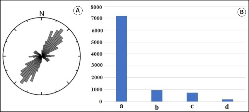
Figure 3: Proportion of lineaments directions: A. Rose diagram of main lineaments directions and B. Histogram showing lineament frequency (a. NNE-SSW to Ne-SW trending dykes; b. EW to ENE-WSW trending dykes; c. NW-SE to WNW-ESE trending dykes and d. N-S trending dykes.
Geophysical data
After applying the IGRF conventional correction to the airborne magnetic data, the calculated residual map was used in further processing to produce RTP, analytic signal and vertical derivative maps (Ba et al. 2020b). The RTP map clearly shows the response of the dykes as short-wavelength linear anomalies that crosscut the study area following three main directions: NNE-SSW to NE-SW, NW-SE to WNW-ESE and E-W (Fig. 4A.). Comparison of the RTP and the analytic signal maps (Fig.4B.) highlights the strongly textured magnetic patterns. Comparison with the surface geology shows that the known mafic dykes are most often associated with high amplitude anomalies, particularly in the western half of the study area (Fig. 4A.). However, some of the dykes obtained from geological maps that are denoted by letters “Dnm” in Fig. 4A., do not generate clear magnetic signatures and are therefore non-magnetic. This is the case of the Ahmeyim Great Dyke. In contrast, many narrow and very elongated anomalies representing mafic dykes referred to as “Dp” were highlighted (Fig. 4A.). The present study also allows the mapping of numerous mafic dykes that were formerly unknown because they were either hidden by sand or did not reach the surface. It should be noted that mafic dykes had already been mapped in some places covered by sand in the Chami region (Key, 2003), southwest of the study area, but the detection method is not specified (Fig. 1C).
The use of gamma-ray spectrometry data (Fig. 4C) has also resulted in the delineation of potassium-enriched areas that may correspond to potassic alterations that may be associated with hydrothermal activity and ore deposition (Ba et al. 2020b).
A map summarizing the integrated results of both aeromagnetic and gamma-ray analyses (Fig. 4D.) contributes to understanding of the western part of the Reguibat Shield by adding important details to the existing structural map, in particular in the vast areas occupied by the Azefal and Akchar dunes. The obtained results show three dyke swarms extending over the entire study area as illustrated by the rose diagrams A, B, C and D of Fig. 4D.:
- Swarm A: The most conspicuous swarm is that trending NNE-SSW to NE-SW (represented in black lines), with individual dykes extending for several tens of kilometres in the western part of the study area. However, in the east, they become shorter (typically a few kilometres in length);
- Swarm B: The second swarm comprises the NW-SE to WNW-ESE trending dykes (represented in blue lines). These dykes appear in scattered places across the study area where they extend for a few kilometres, except in the southwest where a dyke has been mapped over more than 200 km;
- Swarm C: The third dyke swarm has an E-W trend (represented by red lines). It is less developed and appears mostly in the southern part of the study area. The age of this dyke swarm is unknown.
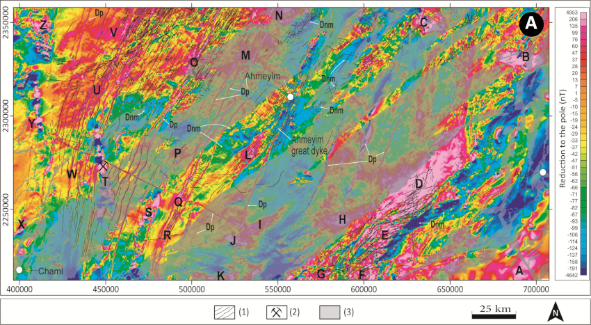
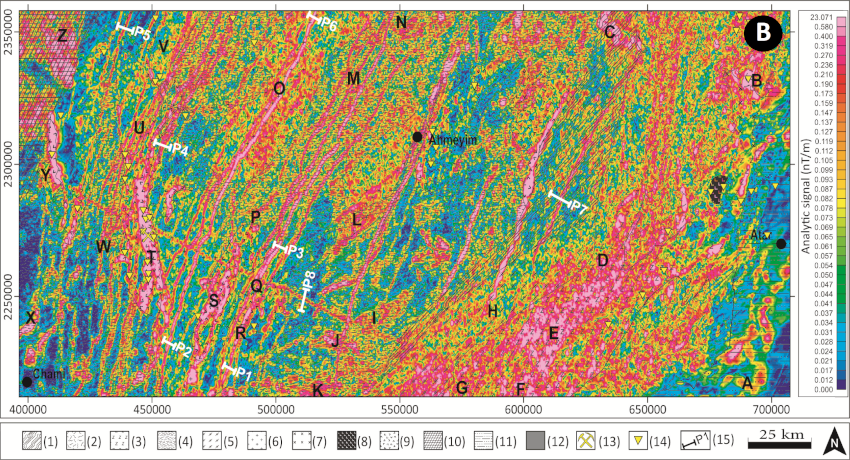
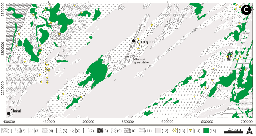
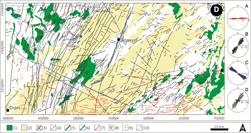
Figure 4: A. Map showing the mafic dyke swarms (black lines) superimposed on the magnetic data reduced to pole. 1. Mafic dykes, 2. Tasiast mine, 3. Sand dunes. The magnetic anomalies are indicated by capital letters A to Z, Dnm: Non-magnetic dyke, Dp: Mafic dyke generating positive magnetic anomaly; B. Geological map of the study area superimposed on a map of the analytic signal of the magnetic field (same legend as Fig. 1C.); C. Maps showing interpreted areas of high values of K and K/Th superimposed on the geological map (same legend as Fig. 1C.) and D. Interpretation map synthesizing the obtained results. 1. Areas of high K and K/Th values, 2. Sand dunes, 3. Interpreted magnetic lineaments, 4. Interpreted faults, 5. Contours of the Ahmeyim Great Dyke according to the geological map (Sheet of Ahmeyim at the scale of 1/200,000, Key and Loughlin, 2003), 6. Negative magnetic anomaly associated with the Ahmeyim Great Dyke, 7 - Axis of the negative magnetic anomaly of the Ahmeyim Great Dyke, 8. Mine, 9. Mineralisation indices, 10. Railway. A, B and C represent the rose diagram of the mapped magnetic lineaments-oriented E-W, NNE-SSW to NE-SW and NW-SE to WNW-ESE respectively. D. Rose diagram of all magnetic lineaments.
Geochronological data
The first dating in this same region was the work of Dosso et al. (1979) on dolerite dykes of the Amsaga, which gave ages of 1,470 Ma, 1,610 Ma, and 1.750 Ma. Aïfa et al. (2001) obtained ages between 1,400 and 1,900 Ma on others dyke bundles in the eastern part of the Reguibat Shield.
In recent decades, geochronological studies based mainly on U-Pb methods on zircon which are more reliable and accurate, were used to date some dykes within the Reguibat Shield. Pitfield et al. (2004), dated the Ahmeyim Great Dyke on the basis of U-Pb zircon to about 550 +/- 3 Ma, although isotopic analyses of various zircon populations indicated older ages of 600 Ma, 750 Ma, and 2,000 Ma, similar to those whose source is the Archean crust. This first dating of the Great Dyke is contradictory to previous attempts at dating that had given Paleroterozoic ages for dyke swarms (e.g., Dosso et al., 1979; Aïfa et al., 2001). In addition, the swarms of mafic dykes outcropping in the Archean basement of the Amsaga are covered by the basal part of the Char Group, which is a sequence of the Hodh Supergroup (age >1,000 Ma) in the Taoudéni basin (Pitfield et al. 2004; Rooney et al. 2010); this would place the age of the Ahmeyim Great Dyke and these satellite dykes mafic to be older than 1,000 Ma.
Tait et al. (2013), cast doubt on the previous age for the Ahmeyim Great Dyke, attributing an Archean age of about 2733 +/- 2 Ma by the U-Pb method on baddeleyite. An age of 2688 +/- 3 Ma (U-Pb on baddeleyite) slightly younger than that of the Great Dyke (45 Ma difference), was obtained on a dyke of the NW trending plagioclase-porphyritic Aousserd-Tichla (Moroccan Sahara) (Söderlund et al., 2013).
Petrographical and Geochemical data
Petrographic study of the Ahmeyim Great Dyke and its satellite mafic dykes made it possible to determine their structural and mineralogical variation, as well as their geographical density within the Archean of Tasiast-Tijirit Terrane. Structurally, these mafic dykes are mainly composed of gabbros, gabbronorites, dolerites and gabbro-dolerites. These lithologies have mineralogy comprising plagioclase + clinopyroxene (augite) ± orthopyroxene (hypersthene) ± hornblende ± olivine ± biotite, displaying variable grain sizes. From the geochemical point of view, they have basaltic to andesitic compositions of a sub-alkaline nature (Fig. 5A and B). Different geotectonic discrimination diagrams of trace elements and Rare Earth Elements (REEs) reveal basaltic suites of continental LIP that originate from a source of mafic magma that was enriched in light rare earths (LREE) (Fig.5C.). On the discrimination diagram of basaltic sequences of LIPs of Pearce et al., 2021 (Fig. 5D.) the set of mafic dyke samples plot entirely within the subduction modified lithospheric mantle (SZLM) array (LIP type II), and are consistent with continental LIP magmatism whose chemistry has been modified by interaction with lithosphere which had been metasomatized in a prior subduction event. These groups of dykes are comparable to other basaltic suites of LIP (e.g., Bushveld LIPs (2058 Ma); Matachewan LIPs (2460-2445 and 2480 Ma); Kaminak LIPs (2490 Ma); Karoo-Ferrar LIPs (183 Ma) among others).
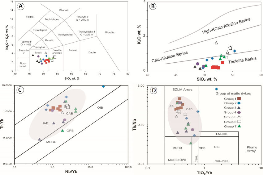
Figure 5: Chemical classification of dyke groups studied according to binary diagrams: A. Na2O + K2O) / SiO2 (after LeBas et al., 1986), Legend: Group 1 = Ahmeyim Great Dyke NNE-SSW; Group 2 = NNE-SSW trending dykes ; Group 3 = NE-SW to WSW-ENE trending dykes ; Group 4 = NW-SE to WNW-ESE trending dykes; Group 5 = NNW-SSE trending dykes; Group 6 = N-S trending dykes of the Reguibat Shield; Group 7 = N-S trending dykes of Mauritanides (CAMP); B. Versus Silica K2O/SiO2 (after Rickwood (1989) (same legend as Fig. 5A.); C. Th/Yb vs Nb/Yb (after Pearce et al., 2021) Key: MORB = Mid-ocean ridge basalt, OIB = Ocean Island basalt, EM-OIB = Enriched mantle-rich OIB, OPB = Ocean plateau basalt, IAB = Island arc basalt, CAB = Calk-alkaline basalt et SZLM = Subduction-modified lithospheric mantle and D. Th/Nb vs TiO2/Yb (after Pearce et al., 2021) (same legend as Fig. 5C.).
References
Aifa, T., Lefort, J.P., Drareni, A., 2001. New paleopoles at 1.4–1.9 Ga from dyke swarms of the West African craton: paleomagnetic contribution to the accretionary phase of Rodinia. Gondwana Research, v. 4, p. 559–560.
Ba, M.H., Ibouh, H., Lo, K., Youbi, N., Jaffal, M., Ernst, R.E., Niang, A.J., Dia, I., Abdeina, E.H., Bensalah, M.K., Boumehdi, M.A., Soderlund, U. (2020a). Spatial and temporal distribution patterns of Precambrian mafic dyke swarms in northern Mauritania (West African craton): analysis and results from remote-sensing interpretation, geographical information systems (GIS), Google Earth ™ images, and regional geology. Arabian Journal of Geosciences, v. 13, 209, https://doi.org/10.1007/s12517-020-5194-2
Ba M.H., Jaffal, M., Lo, K., Youbi, N., El Mokhtar Dahmada, M., Ibouh, H., Boumehdi, M.A., Aïfa, T., Amara, M., Jessell, M., Ernst, R.E., Bensalah, M.K., Söderlund, U. (2020b) Mapping mafic dyke swarms, structural features, and hydrothermal alteration zones in Atar, Ahmeyim and Chami areas (Reguibat Shield, Northern Mauritania) using high-resolution aeromagnetic and gamma-ray spectrometry data Journal of African Earth Sciences, v. 163, 103749.
Ba, M.H., 2022. Le Grand Dyke d’Ahmeyim et les essaims de dykes mafiques satellites :
télédétection, géophysique, pétrologie, géochimie et implications géodynamiques dans le contexte du Terrane Archéen de Tasiast-Tijirit (Dorsale Rgueïbat Occidentale, Mauritanie). Thèse de doctorat de l’Université de Nouakchott Al Aasriya N°001 Dep-Géol; 233 pp.
Bessoles, B., 1977. Géologie de l'Afrique. Le craton Ouest Africain. Mémoires du Bureau de Recherches Géologiques et Minières 88, 402.
Dillon, W.P., Sougy, J.M.A., 1974. Geology of West Africa and canary and Cape Verde islands. In: Nairn, A.E.M., Stehli, F.G. (Eds.), The Ocean Basins and Margins. Springer, Boston, MA, pp. 315–390. https://doi.org/10.1007/978-1-4684-3033-2_10.
Dosso, L., Vidal, P., Sichler, B., 1979. Age précambrien des dolérites de la Dorsale Reguibat (Mauritanie). Comptes Rendus de l’Académie des Sciences de Paris 288,739–742.
Ernst, R.E., 2014. Large Igneous Provinces. Cambridge University Press, 653 p.
Ernst, R.E., Jowitt, S.M., 2013. Large igneous provinces (LIPs) and metallogeny. Society of
Economic Geologists special publication 17, 17-51.
Key, R.M., 2003. 1:200000 Geological Map of the Chami Sheet (2015). Mines Industrie, Government of Mauritania, Nouakchott.
Key, R.M., Loughlin, S.C., 2003. 1:200000 Geological Map of the Ahmeyim Sheet (2014).
Mines Industrie, Government of Mauritania, Nouakchott.
Key, R.M., Loughlin, S.C., Waters, C.N., 2003. 1:200000 Geological Map of the Atar Sheet,
(2013). Mines Industrie, Government of Mauritania, Nouakchott.
Key, R.M., Loughlin, S.C., Gillespie, M., Del Rio, M., Horstwood, M.S.A., Crowley, Q.G., Darbyshire, D.P.F., Pitfield, P.E.J., Henney, P.J., 2008. Two mesoarchaean terranes in the Reguibat shield of NW Mauritania. In: In: Ennih, Nasser, Liégeois, J.-P. (Eds.), The Boundaries of the West African Craton, vol. 297. The Geological Society of London,
Special Publication, pp. 33–52. https://doi.org/10.1144/SP297.3
Lahondère, D., Thieblemont, D., Goujou, J, G., Roger, J., Moussine-Pouchkine, A., Le Metour, J., Cocherie, A., Guerrot, C., 2003. Notice explicative des cartes géologiques et gîtologiques à 1/200 000 et 1/500 000 du Nord de la Mauritanie. DMG, Ministère des Mines et de l’Industrie, Nouakchott, volume 1.
Pearce, J.A; Ernst, R.E; Peate, D.W and Rogers, C; 2021. LIP printing: Use of immobile element proxies to characterize Large Igneous Provinces in geologic record. Lithos 106068, 392-393. https://doi.org/10.1016/j.lithos.2021.106068
Pitfield, P.E.J., Key, R.M., Waters, C.N., Hawkins, M.P.H., Scofield, D.I., Loughlin, S., Barnes, R.P., 2004. Notice explicative des cartes géologiques et gîtologiques à 1/200000 et 1/500000 du Sud de la Mauritanie. Volume 1 Géologie : Direction des Mines et de la Géologie (DMG), Ministère des Mines et de l'Industrie, Nouakchott.
Rickwood, P. C. 1989. Boundary lines within petrologic diagrams which use oxides of major and minor elements. Lithos, 22(4), 247–263. https://doi.org/10.1016/0024-4937(89)90028-5
Rocci G., Bronner G. and Deschamps M., 1991. Crystalline basement of the West African
Craton. In: R.D. Dallmeyer and J.P. Lécorché (eds) The West African Orogens and
Circum-Atlantic Correlatives. Springer Verlag, Berlin, Heidelberg.
Rooney, A.D., D. Selby, J.-P.Houzay, and P.R. Renne., 2010. Re-Os geochronology of a
Mesoproterozoic sedimentary succession, Taoudeni basin, Mauritania: Implications for basin-wide correlations and Re-Os organic-rich sediments systematics. Earth and Planetary Science Letters, 289 (3-4), 486–496
Schofield, D.I., Horstwood, M.S.A., Pitfield, P.E.J., Gillespie, M., Darbyshire, F., O'Connorc, E.A., Abdouloye, T.B., 2012. U–Pb dating and Sm–Nd isotopic analysis of granitic rocks from the Tiris Complex: new constraints on key events in the evolution of the Reguibat Shield, Mauritania. Precambrian Res. 204–205, 1–11
Söderlund, U., Ernst, R.E., Youbi, N., Rjimati, E.C., Zemmouri, A. 2013. A major Archean (2688 Ma) dyke swarm discovered in the western Reguibat Shield, West African craton, Morocco. Unpublished Report # A131 (20 February 2013). Industry Consortium Project for Reconstruction of Supercontinents Back To 2.7 Ga Using the Large Igneous Province (LIP) Record (www.supercontinent.org), 6p.
Tait, J., Straathof, G., Söderlund, U., Ernst, R.E., Key, R., Jowitt, S.M., Lo, K., Dahmada, M.E.M., N'Diaye, O., 2013. The Ahmeyim Great dyke of Mauritania: a newly dated Archaean intrusion. Lithos 174, 323–332. https://doi.org/10.1016/j.lithos.2012.09.014