May 2021 LIP of the Month
The Derceto Large Igneous Province (LIP), Astkhik Planum, Venus
Lauren MacLellan (1), Richard Ernst (1,2), Hafida El Bilali (1), Richard Ghail (3), Erin Bethell (1)
1 Department of Earth Sciences, Carleton University, Ottawa, ON, Canada
2 Faculty of Geology and Geography, Tomsk State University, Tomsk, Russia
3 Department of Earth Sciences, Royal Holloway University of London, Egham, TW20 0EX,
United Kingdom
Emails: laurenmaclellan@cmail.carleton.ca (Lauren MacLellan); Richard.Ernst@ErnstGeosciences.com (Richard Ernst)
Extracted and modified from:
MacLellan, L.M., Ernst, R.E., El Bilali, H., Ghail, R.C., Bethell, E. (2021a). Volcanic history of the Derceto large igneous province, Astkhik Planum, Venus. Earth Science Reviews, 103619, https://doi.org/10.1016/j.earscirev.2021.103619
Large Igneous Provinces (LIPs) on Earth are voluminous (> 0.1 Mkm3); frequently above 1 Mkm3), mainly mafic(ultramafic) magmatic events of intraplate affinity (based on tectonic setting and/or geochemistry) that occur in both continental and oceanic settings, are often linked with mantle plumes, and are typically emplaced over a short time period ( < 5 myr; often < 2 myr) or in multiple short pulses with a maximum duration of a few tens of myr (e.g., Coffin and Eldholm, 1994; Courtillot and Renne, 2003; Bryan and Ernst, 2008; Bryan and Ferrari, 2013; Ernst, 2014; Ernst et al. 2021). LIPs consist of volcanic packages (flood basalts) and a plumbing system of regional dyke swarms (linear, radiating, and a recently identified circumferential type), sill complexes, layered mafic-ultramafic (M-UM) intrusions, and crustal magmatic underplates (Ernst et al. 2019; Buchan and Ernst, 2021). Continental LIPs can also be associated with major silicic magmatic events termed Silicic LIPs (SLIPs), as well as carbonatites and kimberlites. LIPs and SLIPs are associated with regional uplift, attempted continental breakup, various classes of ore deposits, and dramatic climate change, including mass extinctions.
Given an absence of plate tectonics, the voluminous basaltic magmatism that covers most of Venus is intraplate and the largest volume events represent LIP analogues (e.g. Head and Coffin, 1997; Hansen 2007; Ernst et al. 2007; Ernst, 2014, Buchan and Ernst 2021). Another important difference from Earth is the hyper-warm (450oC) dense CO2-dominated atmosphere associated with global loss of water and no significant surface erosion. [However, it has recently been suggested that Earth-like conditions with potential fluvial erosion may have existed for most of Venus’s history up into the time of the tesserae, the complexly deformed and stratigraphically oldest units (Way et al. 2016; Way and Del Genio, 2020, Khawja et al. 2020, Byrne et al. 2021).]
As a consequence, Venus (at least post-tesserae time) preserves the surface record of LIP volcanism, but the characteristics of the LIP plumbing system are inferred only indirectly (e.g. Buchan and Ernst, 2021). This contrasts with the Earth where erosion has removed the volcanic component (particularly for pre-Mesozoic continental LIPs) but has exposed parts of the LIP plumbing system. Thus, the combined and integrated analysis of the LIP records on Venus and Earth has the potential to produce a more comprehensive understanding of LIPs (including their emplacement history, plumbing systems, and influence on climate) (e.g. Ernst and Buchan 2021).
Herein we report on our detailed mapping at 1:500,000 scale of the Derceto Corona (DC) LIP event located in southern Astkhik Planum, Venus (our map area: 1,920,000 km2) using full resolution (100-200 m/pixel) Magellan synthetic aperture radar (SAR images) (Figure 1; see MacLellan et al. 2021a for full details). This mapping builds on earlier reconnaissance scale mapping (1:5,000,000 scale) in parts of Venus quadrangles V-44, V-45, and V-56 (Bridges and McGill, 2002; Hansen and Tharalson, 2014, and Kumar and Head (2013), respectively), and also on reconnaissance mapping by Lancaster et al. (1995).
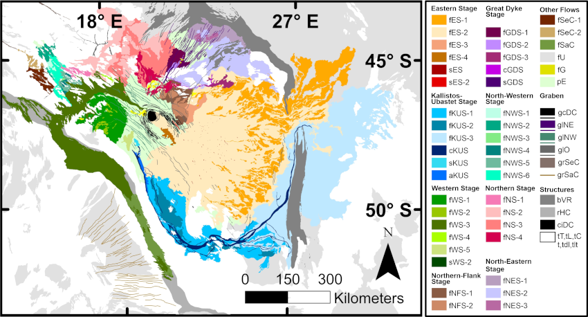
Figure 1: Geological map of our study area (sinusoidal projection with a central meridian of 25 with Venusian geoid) grouped by volcanic stages. bVR = Vaidilute Rupes, fES = Eastern Stage flows, fG = graben-fed flows, fGDS = Great Dyke Stage flows, fKUS = Kallistos- Ubastet Stage flows, cKUS = Kallistos-Ubastet Stage channel fNS = Northern Stage flows, fNES = NE Stage flows, fNFS = Northern Flank Stage flows, fNWS = NW Stage flows, fSaC =Sarpanitum Corona flow, fSeC = Selu Corona flows, fWS = Western Stage flows, fU = Unrelated flows, gcDC = Derceto Corona graben, glNE = NE-trending graben, glNW = NW-trending graben, glO = Other graben, grSaC = Sarpanitum Corona graben, grSeC = Selu Corona graben, pE = Earliest plains flow, rHC = Hanghepiwi Chasma, tC = Clidna tessera, tL = Lhamo Tessera, tT = Tyche Tessera. sES-1, sES-2, sKUS, sWS-1, and sGDS indicate the mapped source of flows. Locations are given in Figure 2. For more details see MacLellan et al. (2021a)
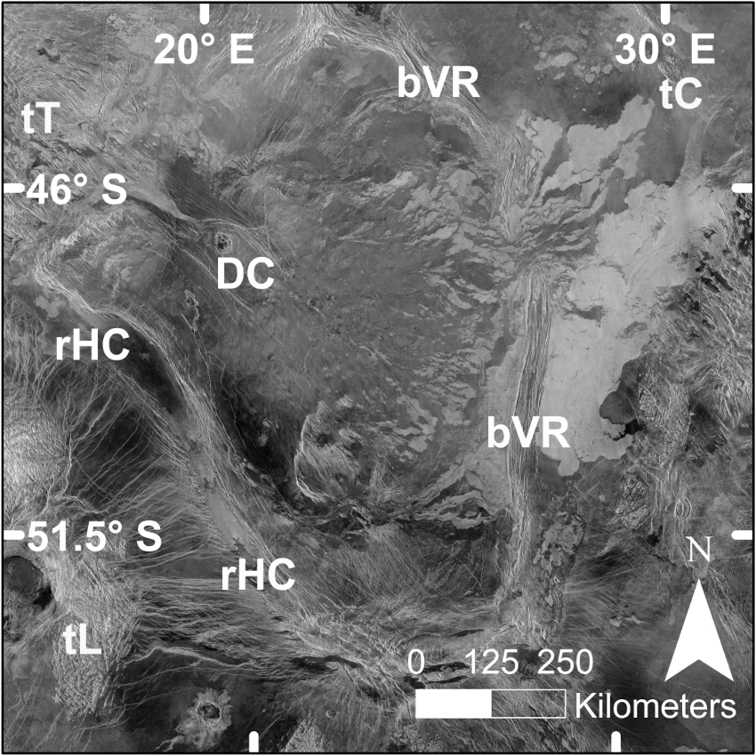
Figure 2: Magellan SAR image of the Derceto area with labelled features. DC =Derceto Corona, rHC =Hanghepiwi Chasma (rift zone), bVR =Vaidilute Rupes, tT =Tyche Tessera, tL =Lhama Tessera, tC =Clidna Tessera,
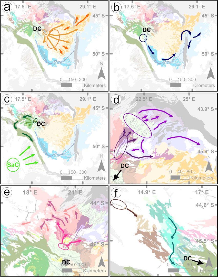
Figure 3: Summary of flow patterns superimposed on geologic mapping (Fig. 1). a) fES (light orange =fES- 2, dark orange =fES-1), b) fKUS, c) fWS (dark green =fWS-3, light green =fWS-1) and fSaC (lime green), d) fGDS (dark purple) and fNES (light purple), e) fNS (light pink =fNS-2, dark pink =fNS-3, medium pink =fNS-4), f) fNWS (blue) and fSeC (brown). DC (and with arrows in parts d, e and f) indicates location of Derceto Corona (DC). Ellipses locate the source for the flows and their colour corresponds to the flow stage described above. Full details in MacLellan et al. (2021a)
The map (Fig. 1) includes a total of thirty-seven distinct lava flow units which were grouped into eight main and multiple minor volcanic stages, along with six regional graben systems (marking underlying dyke swarms). The distribution of the main flow stages are illustrated in Figure 3, and are briefly described here (full details in MacLellan et al. 2021a). On the east side of DC (Fig. 3a), the Eastern Stage flows (fES) which extend for 750 km, are fed from NNW-NW-trending grabens (overlying dykes) and from more local (small shield) sources. The Kallistos-Ubastet Stage (fKUS) (Fig. 3b) consists of the 1200 km long Kallistos Vallis and its overflow Ubastet Fluctus, all fed from an irregular 30 x 10 km depression (interpreted to represent roof collapse above a magma chamber) on the south side of DC. Lavas of both the Eastern Stage and the Kallistos-Ubastet Stage flowed over a section of Vaidilute Rupes and spread out on its eastern side. A Western Stage flow field (fWS-3) (>1000 km long) (Fig. 3c) was sourced from the elliptical graben system (overlying dykes) of DC; after flowing downslope to the north it swings almost 180 degrees to follow a pre-existing rift, Hanghepiwi Chasma (Fig. 2). At its distal end, fWS-3 is locally superimposed with radar-bright flows interpreted to be derived from east trending grabens (overlying dykes) belonging to Sarpanitum Corona. On the north side of DC, (Fig. 3d) a laterally propagating NE-trending graben system (overlying dykes) produces a 90 km “Great Dyke” that itself feeds a flow field; additional grabens of this swarm also spawned smaller flows.

Figure 4: Age relationships of all mapped units in Fig. 1 with youngest at the top. The bolded vertical line separates flows belonging to Derceto Corona on the left from flows with non-Derceto sources on the right. Horizontal lines connecting units indicate direct relationships and question marks indicate the absence of a lower or upper constraint, b) Areal extents of units. Arrows indicate minimum estimates, c) Source elevations of units (see MacLellan et al. 2021a). Arrows indicate that the elevation value is a minimum estimate.
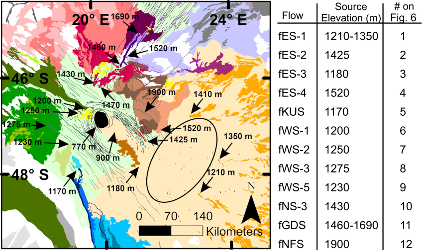
Figure 5: Location and elevation of sources for flow systems, superimposed on geological map (see legend in Fig. 1). The black ellipse indicates the region of NNW- to NW-trending grabens and local shield volcanoes feeding fES-1 and -2. These elevations for inferred sources are consistent with the mapped flow directions and are thus thought to be the elevations at the time of emplacement.
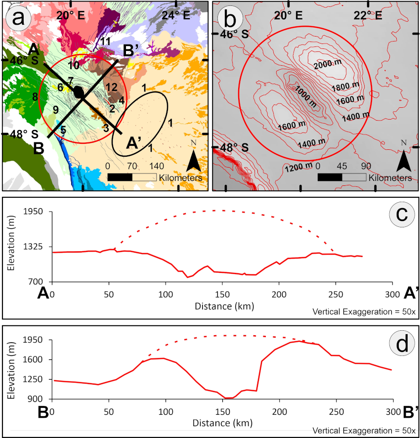
Figure 6: Model for location of magma chamber at Derceto Corona, prior to inferred caldera collapse b) Geology map with red circle enclosing all the sources linked to the central collapse. The black ellipse indicates the region of NNW- to NW-trending grabens and local shield volcanoes feeding fES-1 and -2 (Fig. 3a). b) Topography of area with red circle outlining area of interpreted original domal uplift breached by elliptical collapse (same area as in part a). c) NE-SW topographic profile, d) with NW-SE topographic profile. For parts c and d, an additional dotted line marks the proposed original elevation prior to collapse.
As a final aspect we have attempted to link these various major flow stages (Fig. 3) and their relative ages (Fig. 4) with evolution of the DC magmatic centre (Fig. 5). Two flow stages, Western Stage-3 (Fig. 3c) and the Great Dyke/NE-trending dyke swarms (Fig. 3d) are inferred to be fed via dykes from elliptical-shaped down-sag caldera collapse of DC (Fig. 5). Such down-sag collapse associated with coronae has been noticed elsewhere on Venus (e.g., Sacajawea, Head et al. 1991, 1992) and has terrestrial analogues (e.g. Iceland; Gudmundsson et al. 2016). The Eastern Stage flows (Fig. 3a) are fed mostly from a region to the east of the corona, and the rest of the flows are fed via an older (pre-Derceto) regional NW-trending graben system that was reused for transport of magma from a magmatic underplate or fed laterally from the collapse of the central chamber of DC. The total areal extent of flows is 534,650 km2 with an inferred volume of 26,730 km3 (assuming an average flow thickness of 50 m; thickness constraints detailed in MacLellan et al. 2021a), corresponding to LIP-scale in terms of area, and likely LIP-scale volume if the expected underlying plumbing system were catalogued.
Similar detailed (1:500,000 scale) mapping is in progress on other Venusian magmatic centres to further improve understanding of the LIP records of Venus and Earth (Antropova et al. 2021; Braga et al. 2021; El Bilali et al. 2021; Ernst and Buchan, 2021; MacLellan et al. 2021b; Sanchez et al. 2021) and on the recently completed Quadrangle V-32 mapped at 1:2,500,000 scale (Bethell et al. 2019).
References:
Antropova, E.G., Braga, C.H.G., Ernst, R.E., Buchan, K.L., El Bilali, E. (2021). Geological mapping of unnamed volcanic events (centred at 0.6oN and 277.8oE) in eastern part of BAT region, Venus. Lunar and Planetary Science Conference 52, abstract no. 1402.
Bethell, E., Ernst, R.E., Samson, C. (2019), The Geological Map of the Alpha Regio (V-32) Quadrangle, Venus (TJOM-2018-0107) Journal of Maps, v. 15 (2), p. 474-486.
Braga, C.H.G., Antropova, E.G., Ernst, R.E., Buchan, K.L., El Bilali, H. (2021). Detailed mapping of the volcanic center Atira Mons, BAT region, Venus Lunar and Planetary Science Conference 52, abstract no. 1387.
Bridges, N.T., McGill, G.E. (2002). Geologic Map of the Kaiwan Fluctus Quadrangle (V–44), Venus. U.S. Geological Survey Geologic Investigations Series I-2747.
Bryan, S., Ernst, R. E. (2008). Revised definition of large igneous provinces (LIPs). Earth Science Reviews, 86, 175–202.
Bryan, S. E., Ferrari, L. (2013). Large igneous provinces and silicic large igneous provinces: Progress in our understanding over the last 25 years. Geological Society of America Bulletin, 125, 1053–1078. http://dx.doi.org/10.1130/B30820.1
Buchan, K.L., Ernst, R.E. (2021). Plumbing systems of large igneous provinces (LIPs) on Earth and Venus: Investigating the role of giant circumferential and radiating dyke swarms, coronae and novae, and mid-crustal intrusive complexes, Gondwana Research (on-line) https://doi.org/10.1016/j.gr.2021.02.014
Byrne, P., Ghail, R., Gilmore, M., Sengör, A.M.C., Klimczak, C., Senske, D., Whitten, J., Khawja, S., Ernst, R., Solomon, S. (2021). Venus tesserae feature layered, folded, and eroded rocks. Geology, v. 49, p. 81–85,
Coffin, M. F., & Eldholm, O. (1994). Large igneous provinces: Crustal structure, dimensions, and external consequences. Reviews of Geophysics, 32, 1–36.
Courtillot, V., Renne, P. R. (2003). On the ages of flood basalt events. Comptes Rendus Geoscience, 335, 113–140.
El Bilali, H., Ernst, R.E., Buchan, K.L. (2021). Maat Mons, Atla Regio, Venus: magmatic and tectonic history from detailed mapping. Lunar and Planetary Science Conference 52, abstract no. 2529
Ernst, R.E. (2014). Large Igneous Provinces. Cambridge University Press, p. 653.
Ernst, R.E., Buchan, K.L. (2021). Large Igneous Provinces: Integrating lessons from Venus and Earth. Lunar and Planetary Science Conference 52, abstract no. 2359.
Ernst, R.E., Buchan, K.L., Desnoyers, D.W. (2007). Plumes and plume clusters on Earth and Venus: evidence from large igneous provinces (LIPs). In: Yuen, D.A., Maruyama, S., Karato, S.-i., & Windley, B.F. (Eds.), Superplumes: Beyond Plate Tectonics. Springer-Verlag, Berlin, pp. 537–562.
Ernst, R. E., Liikane, D. A., Jowitt, S. M., Buchan, K. L., Blanchard, J. A. (2019). A new plumbing system framework for mantle plume-related continental large igneous provinces and their mafic-ultramafic intrusions. Journal of Volcanology and Geothermal Research, 384, 75–84.
Ernst, R.E., Bond, D.P.G., Zhang, S-H., Buchan, K.L., Grasby, S.E., Youbi, N., El Bilali, H., Bekker, A., Doucet, L. (2021). Large Igneous Province Record Through Time and Implications for Secular Environmental Changes and Geological Time-Scale Boundaries. Chapter 1 In: Ernst, R.E., Dickson, A.J., Bekker, A. (eds.) Large Igneous Provinces: A Driver of Global Environmental and Biotic Changes. AGU Geophysical Monograph 255, pp. 3-26.
Gudmundsson, M.T., et al. (2016). Gradual caldera collapse at Bárdarbunga volcano, Iceland, regulated by lateral magma outflow. Science, 353 (6296). https://doi.org/10.1126/science.aaf8988.
Hansen, V.L. (2007). LIPs on Venus. Chemical Geology, 241: 354-374.
Hansen, V.L., Tharalson, E.R. (2014). Geologic map of the Agnesi Quadrangle (V-45). U.S. Geological Survey, Scientific Investigations Map 3250, scale 1:5,000,000
Head, J.W., Coffin, M.F. (1997). Large Igneous Provinces: a planetary perspective. In Large Igneous Provinces: Continental, Oceanic, and Planetary Flood Volcanism, Geophys. Monogr. Ser., 100. edited by J. J. Mahoney and M. F. Coffin. AGU Geophysical Monograph, 100, pp. 411–438.
Head, J.W., Campbell, D.B., Elachi, C., Guest, J.E., McKenzie, D.P., Saunders, R.S., Schaber, G.G., Schubert, G. (1991). Venus volcanism: initial analysis from Magellan data. Science 252 (5003), 276–288.
Head, J.W., Crumpler, L.S., Aubele, J.C., Guest, J.E., Saunders, R.S. (1992). Venus volcanism: classification of volcanic features and structures, associations, and global distribution from Magellan data. J. Geophys. Res. 97, 13153–13197.
Khawja, S., Ernst, R.E., Samson, C., Byrne, P.K., Ghail, R.C., MacLellan, L. (2020). Tesserae on Venus may preserve evidence of fluvial erosion. Nat. Commun., 11, 5789 https://doi.org/10.1038/s41467-020-19336-1.
Kumar, P.S., Head, J.W. (2013). Geologic Map of the Lada Terra Quadrangle (V–56), Venus. US Geological Survey, Scientific Investigations Map 3249.
Lancaster, M.G., Guest, J.E., Magee, K.P. (1995). Great lava flow fields on Venus. Icarus 118, 69–86.
MacLellan, L.M., Ernst, R.E., El Bilali, H., Ghail, R.C., Bethell, E. (2021a). Volcanic history of the Derceto large igneous province, Astkhik Planum, Venus. Earth Science Reviews, 103619, https://doi.org/10.1016/j.earscirev.2021.103619
MacLellan, L.M., Ernst, R.E., El Bilali, H. (2021b). Unnamed lava flow system alon the northeastern margin of Vaidilute Rupes, Venus. Lunar and Planetary Science Conference 52, abstract no. 1726.
Sanchez, J.C., Ernst, R.E., Buchan, K.L., El Bilali, H. (2021). Canali W-SW of Salus tessera and link with Nabuzana corona. Lunar and Planetary Science Conference 52, abstract no. 1324.
Way, M. J. et al. (2016) Was Venus the first habitable world of our solar system? Geophysical Research Letters, 43, 8376–8383.
Way, M. J, Del Genio, A. D. (2020). Venusian habitable climate scenarios: modeling Venus through time and applications to slowly rotating Venus-like exoplanets. Adv. Earth Space Sci. 125, e2019JE006276.