December 2020 LIP of the Month
The Datong-Galiwinku Reconstructed Large Igneous Province of North China and North Australia
Uwe Kirscher1, Ross N. Mitchell2, Chong Wang2
1University of Tübingen, Tübingen, Germany. Email: uwe.kirscher@uni-tuebingen.de
2Institute of Geology and Geophysics, Chinese Academy of Sciences (IGGCAS), Beijing, China.; Emails: ross.mitchell@mail.iggcas.ac.cn, wangchong@mail.iggcas.ac.cn
Figures and text modified from Kirscher et al. (2020) and Mitchell et al. (2020).
General
The Datong-Galiwinku large igneous province (DG-LIP; Fig. 1) is a proposed reconstructed LIP combining the Galiwinku-Derim Derim LIP of the North Australian craton (NAC) and the Datong-Yanliao LIP of the North China craton (NCC). Both LIPs have been individually studied intensively in terms of geochronology and geologic and aeromagnetic mapping and a link between them has regularly been suggested based on their similar ages and the similar sedimentary packages in which both LIPs intruded (Wang et al., 2019; Zhang et al., 2017). Whereas paleomagnetic results from the Datong-Yanliao LIP were published several years ago (Chen et al., 2013), paleogeographic results from the NAC independent of the NCC-NAC LIP correlation were previously lacking. This year, two studies have been published showing both that a juxtaposition of the two cratons during emplacement of their LIPs is viable (Kirscher et al., 2020) and that climatic signals of both associated sedimentary sequences suggest that the two cratons were part of the same Mesoproterozoic basin (Fig. 2, Mitchell et al., 2020).
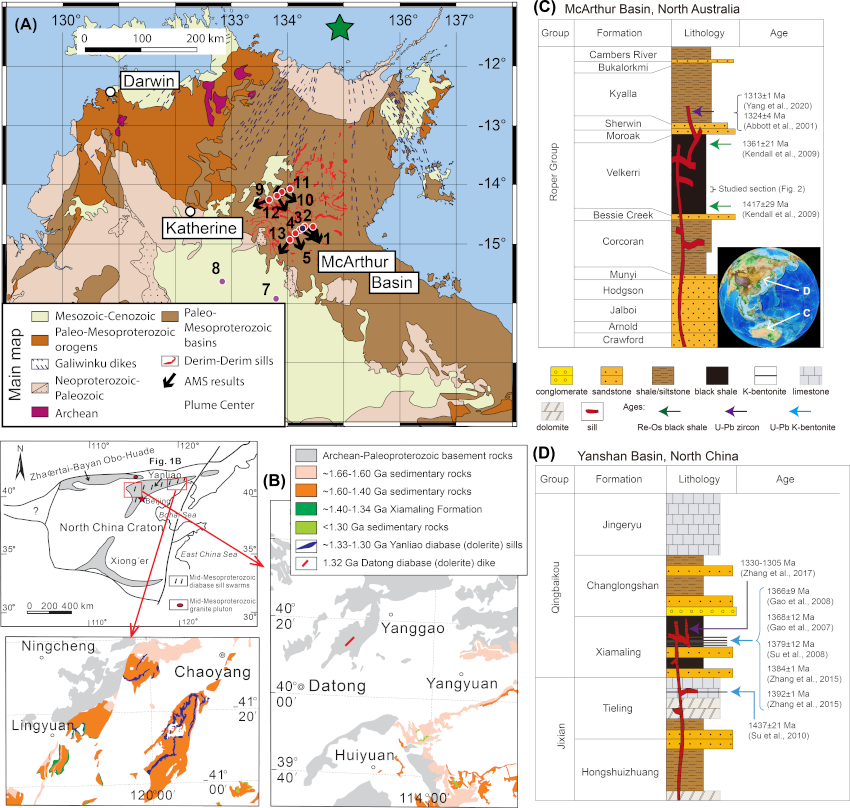
Figure 1: Geologic and lithologic contexts of the Galiwinku-Derim Derim LIP (A and C) and Datong-Yanliao LIP (B and D). (A) Geologic map of Northern Australia including sampling sites of the Derim Derim sill and the corresponding orientations of maximum anisotropy of magnetic susceptibility indicating the direction of magmatic flow (Kirscher et al., 2020). (B) Simplified geologic map of the North China Craton (Zhang et al., 2017). (C and D) Stratigraphic columns of the McArthur and Yanshan Basins of Northern Australia and North China, respectively (Mitchell et al., 2020).
Geochronology
In the NAC, the Galiwinku-Derim Derim LIP comprises the Galiwinku dikes and the Derim Derim sills. The Derim Derim sills intrude the ca. 1.5–1.35 Ga Roper Group of the McArthur Basin in Northern Australia (Fig. 1, Abbott et al., 2001). U-Pb geochronology on the Derim Derim sills reveals ages of 1327.5±0.6 Ma (ID-TIMS on baddeleyite; Bodorkos et al., 2020) and 1312.9±0.7 Ma (ID-TIMS on baddeleyite; Yang et al., 2020), both coeval (within uncertainty) with the 1325±36 Ma (2s) Galiwinku dikes in northern Australia (Bodorkos et al., 2020).
In the NCC, the Datong-Yanliao LIP comprises the Datong dike and the Yanliao sills. The Yanliao sills intrude the Mesoproterozoic Wumishan, Tieling, and Xiamaling formations of the Yanliao rift (Wang et al., 2014; Zhang et al., 2017; Zhang et al., 2009). The Yanliao sills were dated in a number of studies with ages ranging between 1305 and 1330 Ma and an age peak at 1323 Ma (Zhang et al., 2017). The Datong dike was dated using baddeleyite SIMS at 1326±4 Ma (Peng, 2015), coeval with and spatially associated with the Yanliao LIP.
Aeromagnetic expression of the poorly exposed Galiwinku dikes (Goldberg, 2010) and anisotropy of magnetic susceptibility indicative of directions of magmatic flow of the Derim Derim sills (Kirscher et al., 2020) reveal a consistent radial pattern that projects to where the Derim Derim sills intrude the McArthur Basin (Whelan et al., 2016), with a potential plume centre to the present-day north off the coast of Northern Australia in the Arafura Sea. Zhang et al. (2017) used the orientation of the Datong dike to reconstruct the NCC relative to the NAC, which was only slightly modified as constrained independently by paleomagnetic data (Kirscher et al., 2020).
Geochemistry
The Derim Derim sills have SiO2 contents of 50-55 wt.% and show variable Ni, Ba, and Cr contents due to magmatic fractionation and alteration (Abbott et al., 2001). The Yanliao sills have SiO2 contents of 46-57 wt.% and mostly exhibit tholeiitic (subalkaline) basalt to basaltic andesite compositions according to geochemical classification diagrams. Yanliao sills display slightly enriched LREE characteristics, as well as weak Eu anomalies (EuN/EuN* = 0.78-1.1). On primitive-mantle-normalized spider diagrams, the rocks display depletion in Nb, Ta, Sr and, P and enrichment in Rb, Ba, Th, U, and K, and in some cases depletion in Ti (Zhang et al., 2017). On a Zr/Y vs. Zr discrimination diagram, the Yanliao sills show within-plate basaltic affinity (Zhang et al., 2017).
Paleogeography
The DG-LIP plays an important role for the reconstruction of Paleoproterozoic-Mesoproterozoic supercontinent Columbia/Nuna since it adds two constituent continents to the core of the supercontinent comprised of Laurentia, Baltica, and Siberia. The inclusion of Australia and NCC in supercontinent Nuna was proposed in many past reconstructions (Chen et al., 2013; Evans and Mitchell, 2011; Zhang et al., 2012), however, details on the configuration and the duration remained only loosely constrained. Whereas Pisarevsky et al. (2014) locates NCC further away from the core of Nuna and juxtaposed to the West Australian Craton, Meert and Santosh (2017) interpret the paleomagnetic evidence as too poor to argue for the addition of neither Australia nor NCC to supercontinent Nuna. Only now with the new paleomagnetic pole of the Derim Derim sills, is it possible to verify the addition of the Australian cratons during the whole tenure of Nuna (Fig. 2, Kirscher et al., 2020). This is further supported by similar paleoclimatic signals within black shale deposits of both the Velkerri and Xiamaling formations of NAC and NCC, respectively (Fig. 3, Mitchell et al., 2020). This recent reconstruction is further supported by magmatic barcode matching between Laurentia, Siberia, and Yangtze (Lu et al., 2020) with the ca. 1.74 Ga Lunch Creek Gabbro in Australia (Neumann et al., 2009). The paleomagnetic data from Australia extends the SWEAT (southwestern U.S.–East Antarctica) connection of Laurentia and Australia from ca. 1.6 Ga until the ca. 1.3 Ga DG-LIP (Kirscher et al., 2020). The similarity of the sedimentary basins of NAC and NCC (Wang et al., 2019) and the occurrence of the DG-LIP further implies a connection of NAC and NCC during the same time span making the Pangea-sized supercontinent Nuna the longest lived of all known supercontinents.
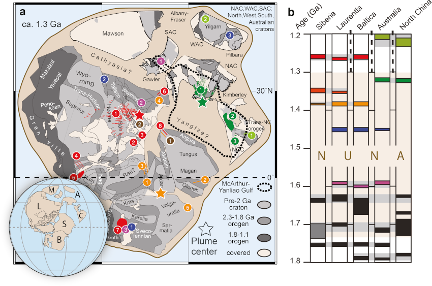
Figure 2: (a) Paleogeographic reconstruction of the Nuna supercontinent (modified after Kirscher et al., 2020) at ca. 1.3 Ga including the position of the Galiwinku-Derim Derim LIP (1), the Yanliao LIP (2) and the Datong dike (3). (b) Barcode of LIPs of the main Nuna continents for the 1.8-1.2 Ga interval. Color coded similar as in a. LIP shown in a: Pink: 1) Gawler Range Volcanics and Olympic Dam breccia, 2) Western Channel Diabase sills and Wernecke breccia, 3) Breven-Hällefors dykes and Rapakivi intrusion. Green: 1) Derim Derim sills and Galiwinku dykes, 2) Yanliao sills, 3) Datong dykes. Light green: 1) Licheng dykes, 2) Marnda Moorn dykes. Orange: 1) Midsommer sills, 2) Chieress dyke, 3) Victoria Land sills, 4) Hart River sills, 5) Mashak volcanics. Brown: 1) Listvanka dyke, 2) Barking Dog event, Wellington Inlier. Red: 1) Mackenzie dykes, 2) Nauyat volcanics, 3) Savage Point sills, 4) Harp dykes, 5) Lower Gardar dykes/sills, 6) Bear River dykes, 7) Central Scandinavian dolerite complex, 8) Srednecheremshanskii dyke. Blue: 1) Tuna-Trond/Gota-Lake Ladoga dykes, 2) Moyie sills, 3) Bangemall sills (Bangemall event). For more information please refer to Ernst and Buchan (2001) and the webpage of the “Large Igneous Provinces Commision”: http://www.largeigneousprovinces.org. See also Ernst et al. (2021).
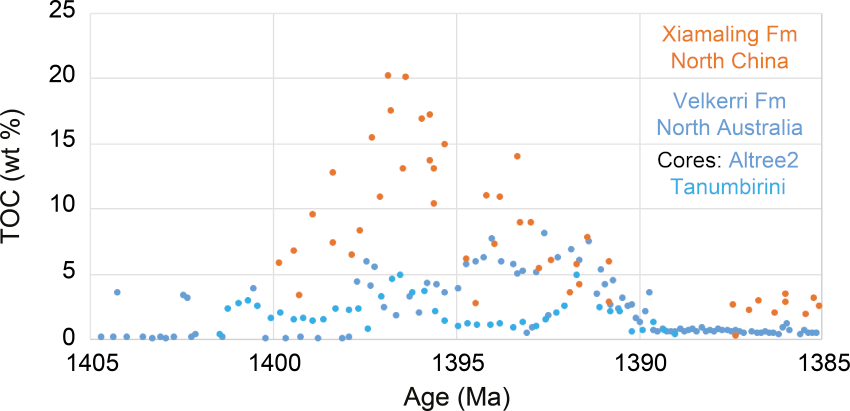
Figure 3: Total organic carbon (TOC) signal of the Xiamaling (orange) and the Velkerri (blue) formations, where the age duration was independently constrained using cyclostratigraphy (Mitchell et al., 2020).
References
Abbott, S. T., Sweet, I. P., Plumb, K. A., Young, D. N., Cutovinos, A., Ferenczi, P. A., and Pietsch, B. A., 2001, Roper Region: Urapunga and Roper River Special, Northern Territory: 1:250 000 geological map series explanatory notes, SD 53-10, 11 (second ed.), Northern Territory Geological Survey and Geoscience Australia (National Geoscience Mapping Accord).
Bodorkos, S., Crowley, J., Claoué-Long, J., Anderson, J., and Magee Jr, C., 2020, Precise U–Pb baddeleyite dating of the Derim Derim Dolerite, McArthur Basin, Northern Territory: old and new SHRIMP and ID-TIMS constraints: Australian Journal of Earth Sciences, p. 1-15.
Chen, L. W., Huang, B. C., Yi, Z. Y., Zhao, J., and Yan, Y. G., 2013, Paleomagnetism of ca. 1.35 Ga sills in northern North China Craton and implications for paleogeographic reconstruction of the Mesoproterozoic supercontinent: Precambrian Research, v. 228, p. 36-47.
Ernst, R. E., and Buchan, K. L., 2001, Large mafic magmatic events through time and links to mantle plume heads: Mantle Plumes: Their Identification through Time, no. 352, p. 483-575.
Ernst, R.E., Bond, D.P.G., Zhang, S-H., Buchan, K.L., Grasby, S.E., Youbi, N., El Bilali, H., Bekker, A. & Doucet, L. (2021). Large Igneous Province Record Through Time and Implications for Secular Environmental Changes and Geological Time-Scale Boundaries. In: Ernst, R.E., Dickson, A.J., Bekker, A. (eds.) Large Igneous Provinces: A Driver of Global Environmental and Biotic Changes. AGU Geophysical Monograph 255, pp. 3-26.
Evans, D. A. D., and Mitchell, R. N., 2011, Assembly and breakup of the core of Paleoproterozoic-Mesoproterozoic supercontinent Nuna: Geology, v. 39, p. 443-446.
Goldberg, A. S., 2010, Dyke swarms as indicators of major extensional events in the 1.9–1.2 Ga Columbia supercontinent: Journal of Geodynamics, v. 50, no. 3-4, p. 176-190.
Kirscher, U., Mitchell, R. N., Liu, Y., Nordsvan, A. R., Cox, G. M., Pisarevsky, S. A., Wang, C., Wu, L., Murphy, J. B., and Li, Z. X., 2020, Paleomagnetic constraints on the duration of the Australia-Laurentia connection in the core of the Nuna supercontinent: Geology.
Lu, G. M., Wang, W., Cawood, P. A., Ernst, R. E., Raveggi, M., Huang, S. F., and Xue, E. K., 2020, Late Paleoproterozoic to Early Mesoproterozoic Mafic Magmatism in the SW Yangtze Block: Mantle Plumes Associated With Nuna Breakup?: Journal of Geophysical Research: Solid Earth, v. 125, no. 7, p. e2019JB019260.
Meert, J. G., and Santosh, M., 2017, The Columbia supercontinent revisited: Gondwana Research, v. 50, p. 67-83.
Mitchell, R. N., Kirscher, U., Kunzmann, M., Liu, Y., and Cox, G. M., 2020, Gulf of Nuna: Astrochronologic correlation of a Mesoproterozoic oceanic euxinic event: Geology.
Neumann, N., Gibson, G., and Southgate, P., 2009, New SHRIMP age constraints on the timing and duration of magmatism and sedimentation in the Mary Kathleen Fold Belt, Mt Isa Inlier, Australia: Australian Journal of Earth Sciences, v. 56, no. 7, p. 965-983.
Peng, P., 2015, Precambrian mafic dyke swarms in the North China Craton and their geological implications: Science China Earth Sciences, v. 58, no. 5, p. 649-675.
Pisarevsky, S. A., Elming, S. A., Pesonen, L. J., and Li, Z. X., 2014, Mesoproterozoic paleogeography: Supercontinent and beyond: Precambrian Research, v. 244, p. 207-225.
Wang, C., Li, Z. X., Peng, P., Pisarevsky, S., Liu, Y. B., Kirscher, U., and Nordsvan, A., 2019, Long-lived connection between the North China and North Australian cratons in supercontinent Nuna: paleomagnetic and geological constraints: Science Bulletin, v. 64, no. 13, p. 873-876.
Wang, Q.-H., Yang, H., Yang, D.-B., and Xu, W.-L., 2014, Mid-Mesoproterozoic (∼1.32Ga) diabase swarms from the western Liaoning region in the northern margin of the North China Craton: Baddeleyite Pb–Pb geochronology, geochemistry and implications for the final breakup of the Columbia supercontinent: Precambrian Research, v. 254, p. 114-128.
Whelan, J. A., Beyer, E. E., Donnellan, N., Bleeker, W., Chamberlain, K. R., Soderlund, U., and Ernst, R. E., 2016, 1.4 billion years of Northern Territory geology: insights from collaborative U-Pb zircon and baddeleyite dating, in Survey, N. T. G., ed., Annual Geoscience Exploration Seminar (AGES) Proceedings: Darwin, p. 115-123.
Yang, B., Collins, A. S., Cox, G. M., Jarrett, A. J. M., Denyszyn, S., Blades, M. L., Farkas, J., and Glorie, S., 2020, Using Mesoproterozoic sedimentary geochemistry to reconstruct basin tectonic geography and link organic carbon productivity to nutrient flux from a Northern Australian large igneous Province: Basin Research.
Zhang, S.-H., Zhao, Y., Li, X.-H., Ernst, R. E., and Yang, Z.-Y., 2017, The 1.33–1.30 Ga Yanliao large igneous province in the North China Craton: Implications for reconstruction of the Nuna (Columbia) supercontinent, and specifically with the North Australian Craton: Earth and Planetary Science Letters, v. 465, p. 112-125.
Zhang, S.-H., Zhao, Y., Yang, Z.-Y., He, Z.-F., and Wu, H., 2009, The 1.35Ga diabase sills from the northern North China Craton: Implications for breakup of the Columbia (Nuna) supercontinent: Earth and Planetary Science Letters, v. 288, no. 3-4, p. 588-600.
Zhang, S., Li, Z. X., Evans, D. A. D., Wua, H., Li, H., and Dong, J., 2012, Pre-Rodinia supercontinent Nuna shaping up: A global synthesis with new paleomagnetic results from North China: Earth and Planetary Science Letters, v. 353-354, p. 145-155.