November 2019 LIP of the Month
Benham Rise Unveiled
Jenny Barrettoa,*, Ray Woodb, John Milsomc
a GNS Science, 1 Fairway Drive, Avalon 5010, Lower Hutt, New Zealand. Email: j.barretto@gns.cri.nz
b CRP-OCS Ltd, Hastings, New Zealand
c Gladestry Associates, The Camp, Gladestry, POWYS HR5 3NY, United Kingdom
Extracted from:
Barretto, J., Wood, R., Milsom, J., 2019. Benham Rise Unveiled: Morphology and Structure of an Eocene Large Igneous Province in the West Philippine Basin. Marine Geology Journal 419 (2020) 106052. https://doi.org/10.1016/j.margeo.2019.106052.
Introduction
The Benham Rise, also called the Philippine Rise, is an oceanic plateau located at the western margin of the Philippine Sea having a surface area of ~ 0.11 Mkm2 and a minimum volume of ~0.13 Mkm3 calculated from a depth of 5000 m (Figure 1). The crust beneath the central Benham Rise is ~15 km thick based on 2D gravity modelling. Initial DSDP Site 292 reports indicated the basalts of Benham Rise were tholeiitic (Ingle et al., 1975) with whole rock K/Ar ages of 37.1±1.0 and 38.2±1.0 Ma (McKee, 1975). Later analyses of Sr, Nd and Pb isotope ratios defined oceanic island basalt (OIB) signatures (Hickey-Vargas, 1991). Benham Rise has been interpreted to be once joined to Urdaneta Plateau (Hilde and Lee, 1984) and that both were produced by hotspot magmatism (Hickey-Vargas, 1998). This article describes the morphological features of Benham Rise as revealed by multibeam bathymetry data sourced from the Philippines National Mapping and Resources Information Administration (NAMRIA). It also presents interpretations of the probable origins of these features as constrained by publicly available geological and geophysical data.
Regional geodynamic setting
Figure 1 shows the Benham Rise as one of several bathymetric highs (e.g. Urdaneta Plateau, Oki-Daito Rise, Oki-Daito and Daito Ridges, and Amami Plateau) in the West Philippine Basin (WPB) (Hilde and Lee, 1984; Ishizuka et al., 2013). The northwest edge of the WPB is presently subducting at the Ryukyu Trench while the southwest edge is subducting at the Philippine Trench. In the middle of the basin is the extinct NW-SE trending Central Basin Spreading Center (CBSC) (Hilde and Lee, 1984; Okino and Fujioka, 2003); the mantle plume source for Benham Rise and Urdaneta Plateau is thought to have been located beneath its western end (Deschamps and Lallemand, 2002; Ishizuka et al., 2013). The axis of the CBSC is not elevated due to an episode of largely amagmatic extension that took place after spreading had ceased and hotspot activity waned (Deschamps et al., 1999; Deschamps and Lallemand, 2002). The WPB is estimated to be no younger than 30 Ma and no older than 60 Ma. Ages of 37-49 Ma have been obtained from K/Ar and Ar/Ar dating of Deep Sea Drilling Program (DSDP) Leg 31 basalt samples (McKee, 1975; Ozima et al., 1983; Hickey-Vargas, 1998) and 35-60 Ma from seafloor spreading magnetic anomalies (Hilde and Lee, 1984).
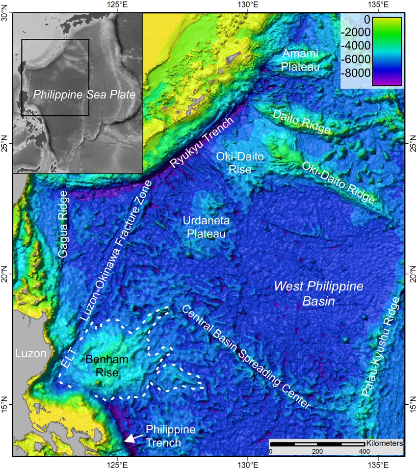
Figure 1. Bathymetry map showing major undersea features in the West Philippine Basin (WPB): Benham Rise, Central Basin Spreading Center, Palau-Kyushu Ridge, Philippine Trench, East Luzon Trough (ELT), Luzon-Okinawa Fracture Zone, Gagua Ridge, Ryukyu Trench, Urdaneta Plateau, Oki-Daito Rise, Oki-Daito Ridge, Daito Ridge, and Amami Plateau. Inset shows map location relative to the Philippine Sea Plate. Background is predicted bathymetry (Version 18.1, Satellite Geodesy, 2014; Smith and Sandwell, 1997).
Morphology and structure
The Benham Rise is a broad undersea feature rising from ~5200 m depth at its base to an average depth of ~2500 m at its crest (Figure 2). Benham Bank, near the southern margin of the rise, shallows to less than 50 m. The rise consists of a main body (~310 km by 330 km) with the Narra, Loro and Molave Spurs extending 100-200 km from its eastern side.
Longitudinal bathymetric profiles show the main body has a broad shield-like platform base rising from depths of ~5200 m to ~3800 m (Figure 2). Platform flanks have gentle gradients from <1° on the lowermost flanks to ~1°-3° on the upper flanks. The gentle slopes can be attributed to the wide terraces making up the flanks. To the south these terraces are ~3-15 km wide and 10-20 km long with slopes of <1° to nearly 3°. These large terraces are thought to result from high magma supply and rapid effusion rates, influenced by both plume and mid-ocean ridge processes (Gregg and Fink, 1995; Geist et al., 2008; Orellana-Rovirosa and Richards, 2016).
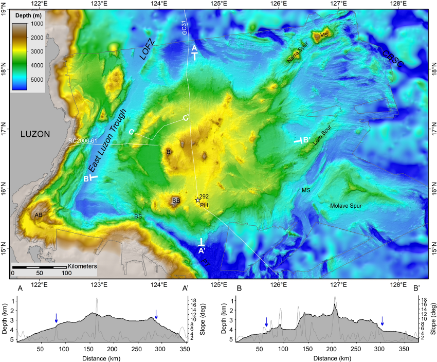
Figure 2. Bathymetric map of the Benham Rise region produced from NAMRIA’s multibeam grid overlaid on a predicted bathymetry grid (Version 18.1, Satellite Geodesy, 2014; Smith and Sandwell, 1997). The thin grey line marks the extent of multibeam data. Locations of bathymetry profiles A-A’, B-B’ and C-C’ (in Figure 3) are plotted on the map together with locations DSDP 31 Site 292 and seismic lines RC2006-61 and GC31. The thin grey curves on the profiles record slope values and the blue arrows point to where the platform base transitions to the crest. Abbreviated feature names are: AB=Aurora Bank, BS=Bicol Saddle, BB=Benham Bank, B=Bayog Seamount, PH=Peña Hill, VS=Vinogradov Seamount, MS=Molave Saddle, PT=Philippine Trench, LOFZ=Luzon-Okinawa Fracture Zone, and CBSC=Central Basin Spreading Center.
The platform is topped by a relatively steeper crest, with flank slopes of ~4°-8° from ~3800 m to 2500 m depth (Figure 2). The crest of Benham Rise has a complex morphology featuring an almost circular but segmented outer ridge enclosing a U-shaped basin to the west, and an elevated central block.
The circular outer ridge is ~150 km in diameter and most pronounced in the western half of the rise. It is less well defined in the eastern half, where it is partially merged with the central block and cut across by NW to NNW trending basins and ridges (Figure 2). In the southwest, the circular outer ridge appears to have been breached and withal that remains is a narrow NW-SE trending ridge. The northwest part of the circular ridge has scalloped inward-facing escarpments or embayments with concave profiles (Figure 3). A bench ~20 km wide and extending for ~55 km is also observed at the bottom of the escarpments. The bench appears to have sub-levels at ~250 m and 150 m above the basin floor.

Figure 3. Profile C-C’ showing a cross-section of the circular outer ridge and basin floor at the NW corner of the crest. Vertical dashed grey lines mark where the profile line changes direction. See profile location on Figure 2.
The floor of the western basin forms a U-shaped moat around the central block (Figure 2). It descends from the east to the west, where it flattens out and where it is ~1 km deep with respect to the outer circular ridge (Figure 3). Where the descent is stepped, the steps form arcuate escarpments that are possibly faults. The lower steps have elevations similar to the benches below the outer ridge to the northwest.
The central block measures ~85 km by 115 km, is generally dome-shaped and on average at ~2500 m depth, but seamounts shallow to ~1000 m and add localized rugged topography (Figure 2). The block has a shallower southwestern side (~3000 m depth) and appears to descend step-wise towards the northeast where it merges with the circular outer ridge. These steps appear to coincide with NW-SE trending lineaments including a 15 to 20 km wide linear trough east of Bayog Seamount (B in Figure 2).
In plan view the geometry of the crest hints at the presence of a crater (Figure 2). Due to its enormous ~150 km diameter, it may be easier to suppose that it is an impact crater than a volcanic caldera. There are, moreover, more morphological features in common with calderas (Lipman, 1997; Cole et al., 2005) than impact craters. The northwest part of the circular outer ridge has a bench that is more typical of an intra-caldera bench on the inner wall of a caldera (Figure 4) than the slumped terraces of the inner wall of an impact crater. The central block with seamounts is more comparable to the uplifted part of a caldera floor (resurgent dome) in silicic resurgent calderas than ringed peaks or peak-rings of impact craters. The U-shaped basin is the caldera floor and the arcuate lineaments to the east are possibly ring faults that accommodated both caldera collapse and resurgence. In recognition of the caldera’s size, we have named it Apolaki (“giant lord”), after the Filipino mythical god of the sun and war.
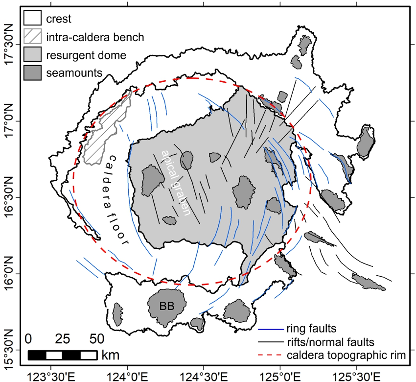
Figure 4. Morphostructural features of Apolaki Caldera. BB=Benham Bank.
The Narra Spur is a complex feature composed of blocky seamounts and intervening saddles that extends northeast for ~155 km from the main body of the Benham Rise (Figure 2). The Loro Spur lies southeast of the Narra Spur and extends ~110 km northeast from the main body. It is an elongated plateau with a terraced platform and a crest made up of cones merged and piled up to more than 1000 m. The Molave Spur is a 200 km long, arrowhead-shaped plateau that forms a southeastern extension of the Benham Rise. Its crest is characterized by V-shaped ridges converging at an axial ridge and the southwestern flank is cut by NW-trending ridges and troughs.
Origin of Benham Rise
The morphological, geological and geophysical data support the earlier interpretation that Benham Rise was formed by hotspot-related magmatism (Hickey-Vargas, 1998) interacting with a spreading ridge (Deschamps and Lallemand, 2002; Ishizuka et al., 2013). Within this framework, a three-stage tectonic evolution is proposed for Benham Rise utilising cross-cutting relationships of morphological features and structures (i.e. lineaments and faults), analysis of adjacent seafloor fabric, and correlation with magnetic spreading anomalies and ages of basement samples from DSDP Site 292 and the Urdaneta Plateau. The three major stages were shield-building, caldera collapse, and post-caldera/late stage volcanism (Figure 5).

Figure 5. Three interpreted major stages in the tectonic evolution of Benham Rise: shield-building, caldera collapse, and post-caldera/late stage volcanism. BR=Benham Rise; UP=Urdaneta Plateau; MS=Molave Spur; AC=Apolaki Caldera; tj=triple junction.
The platform base of the main body and the Molave Spur formed at the northwestern end the spreading center and above the hotspot during the shield-building phase of Benham Rise volcanism (Figure 5), which may have occurred sometime between C21 and C20 (equivalent to ~47.9 Ma to ~42.5 Ma in the revised geomagnetic polarity timescale of Cande and Kent, 1995). The Molave Spur formed along the ESE-propagating arm of a triple junction.
The date of formation of Apolaki Caldera is interpreted to be before the appearance of C19 anomalies or ~41.3-41.5 Ma (Cande and Kent, 1995), when the Urdaneta Plateau was still joined with Benham Rise (Figure 5). A southeasterly jump of the triple junction may have triggered one of the major caldera collapse events. Pre-existing structures, such as the NNW and SW arms at the original triple junction location, may have facilitated the collapse, since the ring faults appear to align with them. Magma was extruded along the NE and SSW arms of the new triple junction and drained the magma chamber beneath the crest of Benham Rise. The Loro Spur may have formed as a result of this rift volcanism along the NE arm.
The post-caldera stage included events of resurgence, post-collapse and late stage magmatism and rifting (Figure 5). Uplift must have been facilitated by the same ring faults that accommodated the caldera collapse, since they form the boundaries of both the caldera and the dome. The triple junction may have migrated again eastward at this stage. Its NNE and SSE arms formed rifts separating the Molave Spur from the main body (Figure 5). The formation of the Narra Spur as the Benham Rise and Urdaneta Plateau separated represents the last and dying stage of hotspot magmatism.
References
Cande, S.C., Kent, D.V., 1995. Revised calibration of the geomagnetic polarity timescale for the Late Cretaceous and Cenozoic. Journal of Geophysical Research 100, 6093-6095.
Cole, J., Milner, D., Spinks, K., 2005. Calderas and caldera structures: a review. Earth-Science Reviews 69, 1-26.
Deschamps, A., Lallemand, S., Dominguez, S., 1999. The last spreading episode of the West Philippine Basin revisited. Geophysical Research Letters 26, 2073-2076.
Deschamps, A., Lallemand, S., 2002. The West Philippine Basin: An Eocene to early Oligocene back arc basin opened between two opposed subduction zones.
Geist, D., Diefenbach, B.A., Fornari, D.J., Kurz, M.D., Harpp, K., Blusztajn, J., 2008. Construction of the Galápagos platform by large submarine volcanic terraces. Geochemistry, Geophysics, Geosystems 9, 1-27. Journal of Geophysical Research: Solid Earth 107, 1-24.
Gregg, T.K.P, Fink, J.H., 1995. Quantification of submarine lava-flow morphology through analog experiments. Geology 23, 73-76.
Hickey-Vargas, R.,1991. Isotope characteristics of submarine lavas from the Philippine Sea: implications for the origin of arc and basin magmas of the Philippine tectonic plate. Earth and Planetary Science Letters 107, 290-304.
Hickey-Vargas, R., 1998. Origin of the Indian Ocean-type isotopic signature in basalts from Philippine Sea plate spreading centers: An assessment of local versus large-scale processes. Journal of Geophysical Research: Solid Earth 103, 20963-20979.
Hilde, T.W.C., Lee, C., 1984. Origin and evolution of the West Philippine Basin: A new interpretation. Tectonophysics 102, 85-104.
Ingle, J.C., Karig, D.E., Bouma, A.H., Ellis, C.H., Haile, N.S., Koizumi, I., MacGregor, I., Moore, J.C., Ujiié, H., Watanabe, T., White, S.M., Yasui, M., Ling, H.Y., 1975. Site 292, in White, S.M. (Ed.), Initial Reports of the Deep Sea Drilling Project, Volume 31, Washington, pp. 67-129.
Ishizuka, O., Taylor, R.N., Ohara, Y., Yuasa, M., 2013. Upwelling, rifting, and age-progressive magmatism from the Oki-Daito mantle plume. Geology 41, 1011-1014.
Lipman, P.W., 1997. Subsidence of ash-flow calderas: relation to caldera size and magma-chamber geometry. Bulletin of Volcanology 59, 198-218.
McKee, E.H., 1975. K-Ar ages of seep-sea basalts, Benham Rise, West Philippine Basin, Leg 31, Deep Sea Drilling Project, in White, S.M. (Ed.), Initial Reports of the Deep Sea Drilling Project, Volume 31, Washington, pp. 599-600.
Okino, K., Fujioka, K., 2003. The Central Basin Spreading Center in the Philippine Sea: Structure of an extinct spreading center and implications for marginal basin formation. Journal of Geophysical Research: Solid Earth 108, 1-18.
Orellana-Rovirosa, F., Richards, M., 2016. Evidence and models for lower crustal flow beneath the Galápagos platform. Geochemistry,_Geophysics, Geosystems 17, 113-142.
Ozima, M., Kaneoka, I., Saito, K., Honda, M., Yanagisawa, M., Takigami, Y., 1983. Summary of geochronological studies of submarine rocks from the Western Pacific Ocean, in Hilde, T.W.C., Uyeda, S., (Eds.), Geodynamics of the Western Pacific-Indonesian region. Geodynamics Series Volume 11. American Geophysical Union, Washington, D.C., pp. 137-142.
Sandwell, D.T., Smith, W.H.F., 2009. Global marine gravity from retracked Geosat and ERS-1 altimetry: Ridge segmentation versus spreading rate. Journal of Geophysical Research 114, 1-18.
[dataset]Satellite Geodesy, 2014. Global topography V18.1 derived from Satellite Geodesy portal. http://topex.ucsd.edu/cgi-bin/get_data.cgi.