June 2019 LIP of the Month
A mantle plume origin for the Scandinavian Dyke Complex: a “piercing point” for 615 Ma plate reconstruction of Baltica?
Christian Tegner1, Torgeir B. Andersen2, Hans Jørgen Kjøll2, Eric L. Brown1, Graham Hagen-Peter1,3, Fernando Corfu2, Sverre Planke2, and Trond H. Torsvik2-4
1) Centre of Earth System Petrology, Department of Geoscience, Aarhus University, Denmark;
Email: cristian.tegner@geo.au.dk
2) Centre for Earth Evolution and Dynamics, University of Oslo, Norway;
3) Norwegian Geological Survey, Norway;
4) School of Geosciences, University of Witwatersrand, WITS 2050, South Africa.
This is a summary and modification of Tegner et al. (2019). Companion papers are Kjøll et al. (2019a, b) and Jakob et al. (2019).
Here we report on the almost 1000 km long doleritic Scandinavian Dyke Complex exposed today in the Caledonian nappes of Norway and Sweden (Fig. 1). Previous work has established that this dyke complex represents magmatism associated with continental rifting and Ediacaran breakup (c. 615-590 Ma) of the Iapetus ocean (Andréasson, 1994; Andréasson et al., 1998; Svenningsen, 2001; Hollocher et al., 2007; Baird et al., 2014; Kirsch and Svenningsen, 2016). Building on this work, we have recently re-examined the tectonic and magmatic evolution of the rifted margin of Baltica. Some of the findings are that:
- The exposed rocks represent a transition from a magma-poor hyperextended rifted margin in the south to a magma-rich rifted margin in the north (Andersen et al., 2012) (Fig. 1). This division probably reflects re-activation of inherited pre-rift lithospheric structures (Jacob et al., 2019).
- The Scandinavian Dyke Complex and their sedimentary host rocks of the magma-rich segment represent a deep portion of a rifted margin that is rarely exposed for study (Kjøll et al., 2019a, b).
- The Scandinavian Dyke Complex represents a large igneous province (LIP) that formed from a mantle plume (Andréasson et al., 1998; Hollocher et al., 2007; Tegner et al., 2019).
- The LIP magmas may have heated and weakened the rifting lithosphere, facilitating continental breakup and initiating the opening phase of the Caledonian Wilson Cycle (Kjøll et al., 2019a).
- The Scandinavian Dyke Complex is part of the much larger Central Iapetus Magmatic Province (CIMP) emplaced in Baltica, British Isles and Laurentia during opening of the Iapetus ocean (Ernst and Bell, 2010) (Fig 1)
Here we (a) report on the petrology and geochemistry of the Scandinavian Dyke Complex, (b) provide a palaeogeographic reconstruction of Baltica and Laurentia using plume generation zones, and (c) discuss the usage of LIPs as piercing points for plate reconstructions.
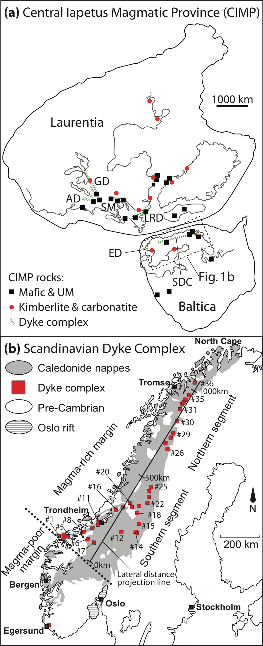
Fig. 1. (a) Locations of magmatic rocks of the Central Iapetus Magmatic Province (CIMP) shown in a reconstruction of the Rodinia supercontinent (Li et al., 2008). Slightly modified from Ernst and Bell (2010) and Torsvik et al. (2010). GD = Grenville Dyke Complex; AD = Adirondack Dyke Complex; LRD = Long Range Dyke Complex; ED = Egersund Dyke Complex; SDC = Scandinavian Dyke Complex; SM = Sutton Mountain triple junction. (b) Map showing the Caledonian nappes of Scandinavia and the subdivision of the pre-Caledonian rifted margin of Baltica into a more than 1000 km long magma-rich margin in the north and a hyperextended magma-poor margin in the south (present frame of reference) (Andersen et al., 2012; Abdelmalak et al., 2015; Jakob et al., 2019). The locations of the 36 areas with outcrops of the Scandinavian Dyke Complex discussed in this contribution and for which we have compiled new and published geochemical data. New data are from the areas #13 (Lunndörs-, Anaris- and Ottfjällene), #27 (Tsäkkok), #28 (Pårte, Sarek National Park) , #29 (Äpar and Sarektjåkka, Sarek National Park), #30 (Kebnekaise National Park), #31 (Nissosnoukki), #32 (Vaivvancohkka), #33 and 34 (Indre Troms), #35 (Tjuotjmer), #36 (Corrovarre). Also shown is a distance line used to estimate the lateral position of the dyke areas from SW to NE. The mid-point of each area is projected orthogonally to the distance line.
The Scandinavian Dyke Complex – a LIP
The dykes outcrop in the Seve, Särv and Corrovarre nappes of the Scandinavia Caledonides (Fig. 1). The dykes are often prominent in the higher grounds of mountain areas and show spectacular outcrops of pristine magmatic dykes intruded into metasediments with cross-cutting relations and chilled margins (Fig. 2). These outcrops constitute large (km-size) low-strain lenses that have largely avoided Caledonian deformation and grade from essentially undeformed dykes and wall-rock metasedimentary hornfelses to strongly deformed and banded gneisses composed of amphibolite with or without garnet (i.e. metamorphosed mafic intrusions) and metasediments (Fig. 2). The Caledonian metamorphism resulting in foliated amphibolite- and locally eclogite facies tectonites (<750°C and 7-14 kbar) (Kullerud, 1990; Andréasson, 1994; Andréasson et al., 1998, Hollocher et al., 2007). The magmatic textures of the dykes range from fine grained basalt over dolerite to micro-gabbros that sometimes carry plagioclase and rare pyroxene phenocrysts. Jadeite-in-clinopyroxene geothermobarometry, titanium-in-biotite geothermometry, and garnet isopleth modeling show that the ambient pressure of the magmatic emplacement was similar for the entire dyke complex at 0.25 to 0.45 GPa; i.e. mid- to upper-crustal levels (Kjøll et al., 2019a).
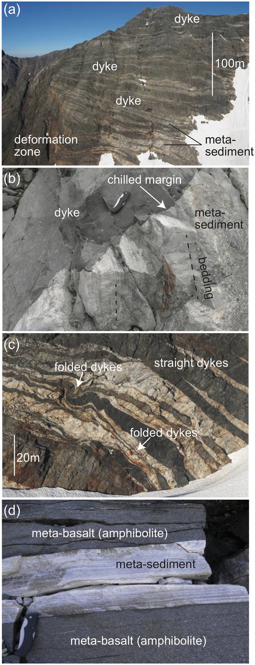
Fig. 2. a) Dyke swarm in the Sarek mountains showing undeformed dykes in the central and upper part of the cliff, and a deformation zone the lower, left part of the outcrop. b) chilled margin of dyke cutting metasediments at a high angle to the original sedimentary bedding. c) Gently folded and deformed dykes underlying straight and undeformed dykes. d) Banded gneiss composed of amphibolite (metamorphosed dyke) and metasediments.
The dyke complex extends over 1000 km in the Caledonian nappes (Fig. 1) and the abundance of dykes range from 20 to >90% in well-exposed areas (Fig. 2). Although the original volume of magmatism is impossible to constrain due to the Caledonian overprint and later erosion, a minimum volume may be estimated from present-day exposures. Klausen (2006) estimated the thickness and width of the Seve and Särv nappes to 4.5-6 km and 80 km, respectively. If a minimum abundance of dykes is assumed to be 30% by volume, and the minimum volume of the nappes is 1000 km long, 80 km wide and 5,3 km thick, the volume of dykes exceeds 0.13 Mkm3. This minimum estimate, alone, fulfils the criteria for the size of a LIP (Ernst, 2014). The short duration for the dyke emplacement discussed above also is similar to other LIPs (Bryan and Ernst, 2008).
Petrology and geochemistry
We have collected new dyke samples (n = 80) over four field seasons (2014-2017) in the areas of Ottfjället, Sarek, Kebnekaise, Tornetrask, Indre Troms, and Corrovarre along the length of the Scandinavian Caledonides (Fig. 1). In addition, we compiled all published geochemical data (n = 550). The new dataset for the Scandinavian Dyke Complex defines a coherent suite of tholeiitic ferrobasalt with 5-11 wt% MgO, 44-53 wt% SiO2 and 9-16 wt% FeOtot (Fig. 3). The TiO2 (1.0-4.0 wt%) and Zr (72-350 ppm) increase, and Cr (684-68 ppm) decreases with decreasing MgO (Fig. 3), consistent with a control by fractional crystallization. The new dataset is similar to the compiled dataset also shown in Fig. 3. In a multi-element diagram the incompatible trace element compositions of dykes from the northern segment form largely flat patterns from the least (right side) to the most (left side) incompatible elements (Fig. 4). The compositional variation is relatively high for K, U, Ba and Rb; this can probably be ascribed to alteration and/or metamorphic effects. The trace element patterns of the southern segment, in contrast, generally increase from right to left, and also shows increased variation for K, U, Ba and Rb.
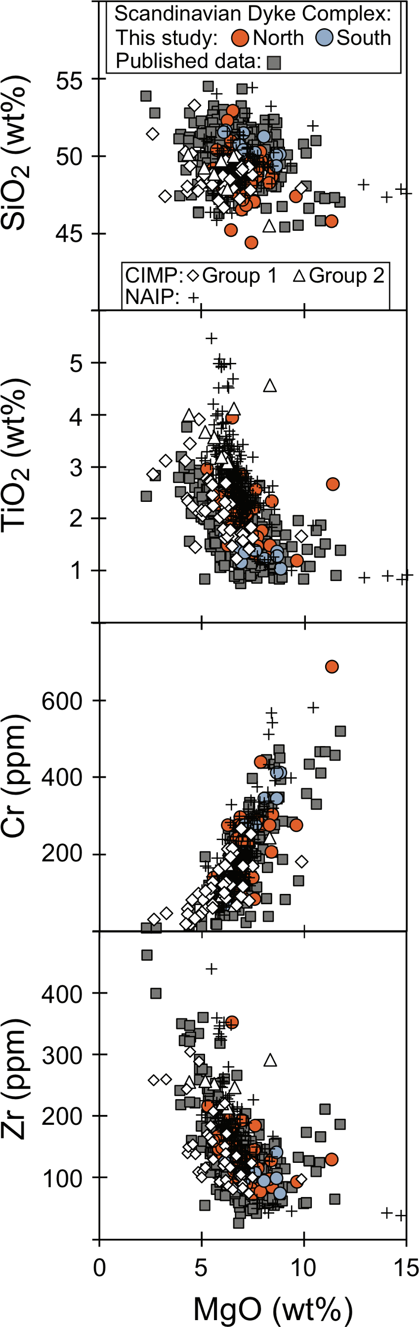
Fig. 3. Compositions of the Scandinavian Dyke Complex for the compiled dataset screened for crustal contamination (36 samples with Th/Nb > 0.15 are excluded) totalling 606 analyses. New data (n = 80) in Supplementary file 2 and published data (n = 550) in Supplementary file 5. Also shown are: (i) flood basalts of the Northeast Atlantic Igneous Province (NAIP) from the 6 km thick volcanic pile in East Greenland (Tegner et al., 1998); (ii) Group 1 tholeiitic dykes of the Central Atlantic Magmatic Province (CIMP) in northeast America (Seymur and Kumarapeli, 1995; Ernst and Buchan, 2010; Volkert et al., 2015); and (iii) Group 2 CIMP dykes in the Sutton mountains of northeast America referred to as Laurentian OIB (Puffer, 2002).
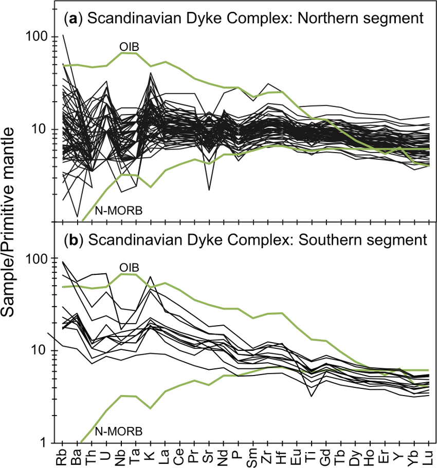
Fig. 4. Multi-element diagram showing the new data of this study for samples of the northern segment (a) and of the southern segment (b) of the Scandinavian Dyke Complex. The elements are arranged with increasing incompatibility in mantle rocks from right to left and are normalized to primitive mantle (Sun and McDonough, 1989). Also shown are normal mid-ocean ridge basalt (N-MORB) and ocean island basalt (OIB) (Sun and McDonough, 1989).
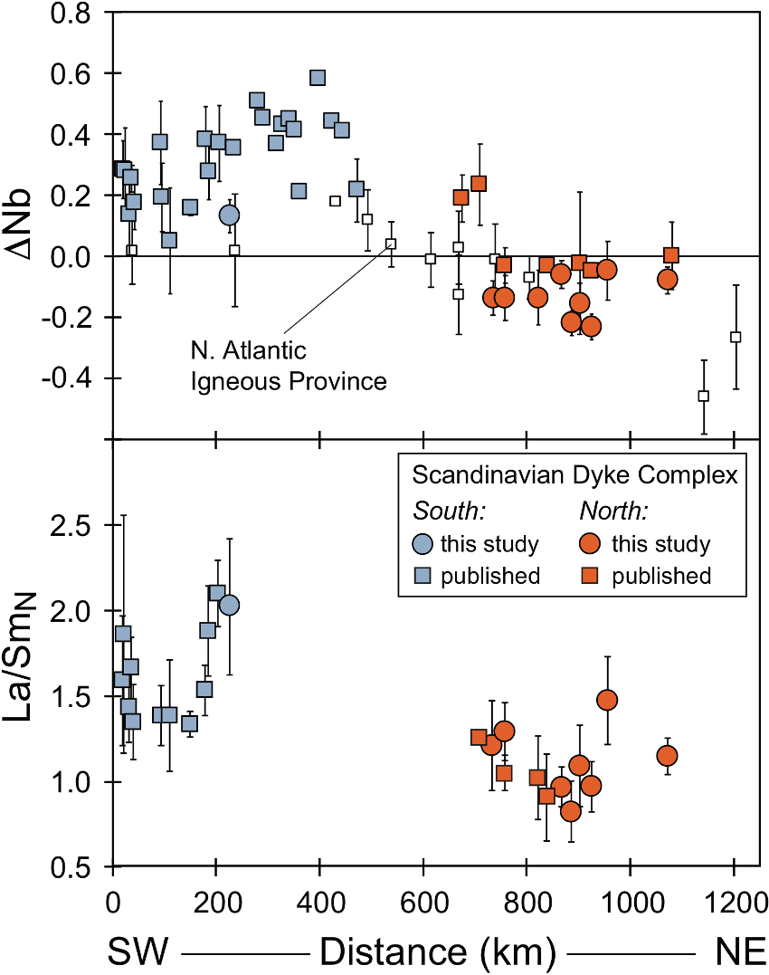
Fig. 5. SW to NE compositional variation in the Scandinavian Dyke Complex. (a) DNb (1 s.d. error bars) showing average values for our new dataset and for the published dataset for 36 locations (Fig. 1, Table 1). Also shown are lateral variations in DNb of the North Atlantic Igneous Province (NAIP) with radial distance from the assumed centre of the proto-Icelandic mantle plume (Fitton et al., 1997). To fit the scale used here, 350 km is subtracted from the published distances to the plume centre; (b) La/SmN for 22 locations where ICPMS data are available (Svenningsen, 1994; Hollocher et al., 2007; Baird et al., 2014; Kirsch and Svenningsen, 2016; this study).
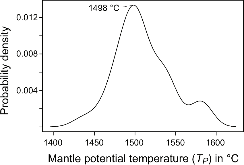
Fig. 6. Gaussian kernel density distribution of mantle potential temperature (TP) calculated for samples of the Scandinavian Dyke Complex (n=32). The final equilibrium temperature and pressure of the magmas in the mantle were calculated using the major element thermobarometer of Lee et al. (2009), and converted to TP using the method described in the text. The TP of the entire dataset, covering 14 locations in both the southern and northern segments, exhibit a gaussian density distribution with a top at 1498 °C, but with four outliers close to 1580 °C The calculations were restricted to largely uncontaminated (Th/Nb < 0.15) and primitive samples that contained more than 8.5 wt% MgO. The data are listed in Supplementary file 13. The kernel density estimations follow the method discussed in Rudge (2008) and were calculated using the Free Statistics Software of Wessa (2015).
To constrain the possible mantle melting dynamics, mantle potential temperature (TP) and source lithologies that can explain the observed compositions of the Scandinavian Dyke Complex, we present the results of mantle melting models. We apply both major and trace element modelling. In particular, we seek explanations for the described lateral geochemical zoning in DNb, La/Sm and 87Sr/86Sr from south to north of the magma-rich margin.
Major element modelling
The major element compositions of primitive basalts can provide constraints on mantle TP (e.g. Herzberg et al., 2007). Notably, such constraints are independent of those derived from the forward trace element modelling discussed below. Here we applied the thermobarometer of Lee et al. (2009) for dyke samples with more than 8.5 wt% MgO, see details in Tegner et al. (2019). Using these criteria, the major element composition of 39 samples were entered into the spreadsheet of Lee et al. (2009) and 32 of these yielded temperature and pressure estimates for final melt segregation in the mantle source. The calculated TP’s range from 1436 °C to 1584 °C for the entire dataset and exhibit a gaussian density distribution with a top at 1498 °C (Fig. 6). We conclude that the major element thermobarometer consistently yields mantle potential temperatures significantly above ambient mantle (DTP of 100-250°C), with a maximum density just below 1500 °C (DTP of 170°C). A significant difference between TP of the southern and northern segments cannot be discerned.
Trace element modelling
We modelled the compositions of basaltic melts produced by melting dynamically upwelling mantle using the REEBOX PRO application (Brown and Lesher, 2016), see details in Tegner et al. (2019). This forward model calculates the composition of the incompatible lithophile trace elements in mantle melts using the latest thermodynamic and experimental constraints on melting reactions and mineral-melt partitioning coefficients, and can simulate passive and active upwelling scenarios, melting of several potential mantle lithologies and allows for exploring variable TP. The data for the southern and northern segments plot in two fields in Fig. 7 with higher La/SmN (1.4 - 2.1) in the southern segment compared to the northern segment (0.9 - 1.5); both segments have about the same range in Dy/YbN (1.16 - 1.33). These values are compared to model results for melting enriched mantle at variable DTP of 0 to 300°C (Fig. 7a). The compositions of dykes in the southern segment are well explained by model melts of primitive mantle for average degrees of melting from 3 to 10% and DTP ranging from 75 to 150°C. The more depleted compositions of the northern segment are best explained by model melts assuming a depleted mantle source (depleted MORB mantle of Salters and Stracke, 2004) (Fig. 6b). The data fall between model curves for DTP ranging from 75-150°C, suggesting average degrees of melting from 3 to 6%.
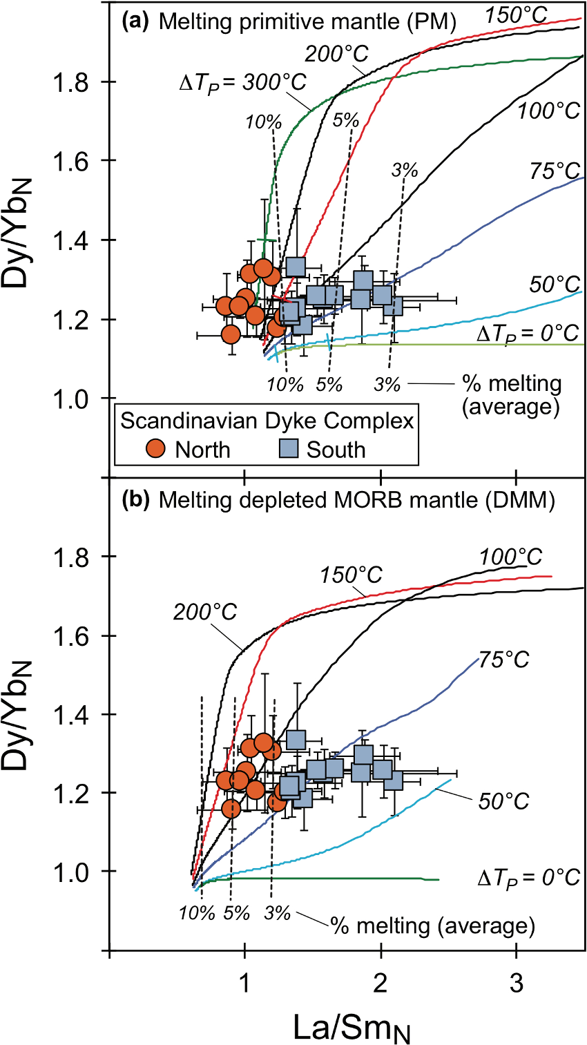
Fig. 7. Dy/YbN vs. La/SmN of the Scandinavian Dyke Complex; symbols separated into southern and northern segments. (a) Forward model melts produced by melting primitive mantle (PM, McDonough and Sun, 1995) at mantle potential temperatures from 1330°C to 1630°C, i.e. up to 300°C above ambient mantle. (b) Forward model melts produced by melting depleted MORB mantle (DMM, Salters and Stracke, 2004) at the same mantle potential temperatures as in (a). Modelling based on REEBOX PRO (Brown and Lesher, 2016), see text.
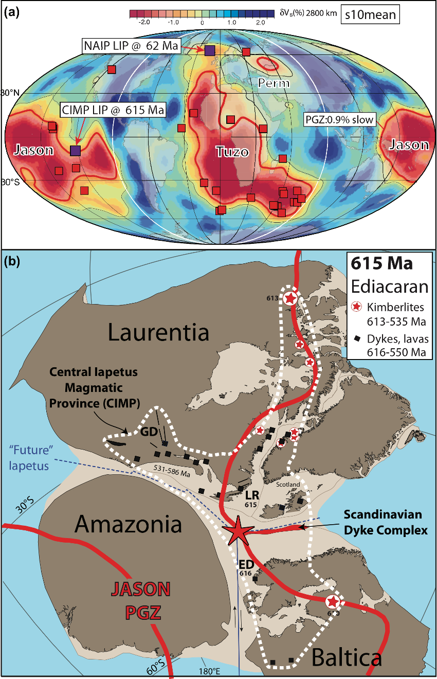
Fig. 8. (a) Reconstructed LIPs (15-297 Ma) draped on the s10mean tomography model where the Plume Generation Zone (PGZ) correspond to the 0.9% slow contour (updated from Doubrovine et al., 2016). Most LIPs overly the PGZs but the Columbia River Basalt is anomalous because it is above a region of faster-than-average anomalies. (b) Paleomagnetic reconstruction of East Rodinia at around 615 Ma using the PGZ reconstruction method calibrated in longitude by LIP related volcanism and kimberlites. The white dotted line indicates the extent of the Central Iapetus Magmatic Province (CIMP, black squares and lines are dykes as in Fig. 1a). Magmatism linked to the CIMP is well preserved in the Caledonian Särv, Seve and Corrovarre Nappes (central Scandinavia), which are characterized by the spectacular Scandinavian Dyke Complex. The dyke complex was emplaced into continental sediments along the nascent Iapetus margin tentatively located in the paleogeographic reconstruction. We have counter-rotated the JASON plume generation zones (thick red line) to account for TPW, so that one can examine how LIP related volcanism and kimberlites directly relate to the PGZs in the paleomagnetic frame. GD = Grenville Dyke Complex; LR = Long Range Dyke Complex; ED = Egersund Dyke Complex. Red star indicate the location of the suggested mantle plume.
We first assessed crustal contamination assuming high Th/Nb is a hallmark of continental crust. We have excluded samples (n = 24) with Th/Nb >0.15 as being significantly contaminated with crust, resulting in a final dataset with 606 samples. However, Sr isotope data for plagioclase show minor crustal contamination of some samples in the final, screened dataset (< 7% crust; Tegner et al., 2019). Such crustal contamination, however, will not change the results of the following analysis of mantle dynamics.
We then assessed lateral geochemical zonation of the dyke complex (Fig. 5). The DNb value of basaltic rocks is a proxy for Nb enrichment of the mantle source. The DNb notation was defined for the present-day North Atlantic where Fitton et al. (1997) demonstrated that in a log-log plot of Nb/Y vs. Zr/Y the basaltic rocks from Iceland defined a compositional field that was relatively enriched in Nb and separated from the compositions of normal mid-ocean ridge basalt away from Iceland. Thus, basalts with positive DNb values are geochemically enriched in Nb (i.e. similar to Iceland) and those with negative values are relatively depleted. The lateral variation in DNb of the Scandinavian Dyke Complex are shown as average values for each mountain area for our new dataset and for the published dataset (Fig. 5a). In both datasets the southern segment has positive DNb reaching values up to +0.59 between 300 and 500 km; i.e. Nb is enriched 5.9 times relative to DNb of zero for a given Zr/Y (Fitton et al., 1997). The northern segment (675-1075 km) has lower DNb and shows a northward decreasing trend with negative values down to -0.23 (Fig. 5a). Other trace elements such as the rare earth elements are only available in the present dataset, and in the more recently published datasets (Svenningsen, 1994; Hollocher et al., 2007; Baird et al., 2014; Kirsch and Svenningsen, 2016). Figure 5b shows the variation in the slope of a light rare earth element (La) relative to a middle rare earth element (Sm) normalized to chondrite (La/SmN). The available La/SmN data also show pronounced lateral differences in both datasets from elevated values (1.35 to 2.10) in the southern segment to lower values in the northern segment (0.87 - 1.47). It thus appears that the Scandinavian Dyke Complex displays lateral zoning in incompatible elements from enriched basaltic compositions in the southern segment to more depleted compositions in the northern segment. This is confirmed by variations in Sr isotope compositions (Tegner et al., 2019).
Geochemical modelling of mantle sources and temperature
We conclude that the lateral compositional changes in the rare earth element compositions of the dyke complex (Figs. 4, 7, 8, 10) are best explained by melting mantle that was anomalously hot relative to ambient mantle (DTP of 75-150°C). Elevated TP is independently confirmed by the major element modelling yielding DTP of 100-250°C with no discernible difference between the southern and northern segments (Fig. 9). The rare earth element modelling shows the melting domain is best explained if it was zoned with enriched lithologies and compositions (primitive mantle) under the southern segment and depleted lithologies and compositions (depleted MORB mantle) under the northern segment. This interpretation is corroborated by the Sr isotope compositions (Fig. 5).
Geochemical modelling of major and trace elements shows these compositions are best explained by melting hot mantle 75-250°C above ambient mantle (Figs. 4, 5). Although the trace element modelling solutions are non-unique, the best explanation involves melting a laterally zoned mantle plume with enriched and depleted peridotite lithologies, similar to present-day Iceland and to the North Atlantic Igneous Province.
A 615 Ma plate reconstruction of Baltica and Laurentia
Not only the Scandinavian Dyke Complex, but also other components of CIMP (Fig. 1) such as the Seiland Igneous Province (Larsen et al., 2018) and magmatic complexes in Laurentia (Puffer, 2002; Hodych and Cox, 2007; Ernst and Bell, 2010) appears to have involved mantle plumes. Here we explore if LIPs of CIMP can be used as piercing points for plate reconstructions by relating them to Large Low Shear-wave Velocity Province (LLSVP) at the core mantle boundary.
Two Large Low Shear-wave Velocity Provinces (LLSVPs) (Garnero et al., 2007) today exists at the core-mantle boundary beneath Africa (dubbed TUZO) and the Pacific (JASON). Using hybrid mantle frames (combination of moving hotspot and true polar wander corrected paleomagnetic frames) it has been argued that the LLSVPs have been stable for at least 300 Myr with deep plumes sourcing LIPs (Fig. 8a) and kimberlites mostly from their margins (Torsvik et al., 2014, 2016). That remarkable correlation between surface volcanism and deep mantle features potentially provides a novel and quantitative way to derive ‘absolute’ plate motions in a mantle reference frame before Pangea. This approach assumes that TUZO and JASON have remained nearly stationary before Pangea time and that the origin of mantle plumes can be tied to their edges. These views are, however, far from being universally accepted and have generated debate in the geophysical literature. See Torsvik et al. (2014; 2016), Doubrovine et al. (2016) and Tegner et al. (2019) for a brief review some of the pros and cons for this assumption.
Palaeogeographic reconstruction using plume generation zones
Assuming that the TUZO and JASON LLSVPs have remained nearly stationary before Pangea time and that the origin of mantle plumes can be tied to their edges it is possible to establish a geologically reasonable palaeogeographic model for the entire Phanerozoic (Torsvik et al., 2014). In this model the continents are positioned using the latitude from palaeomagnetic data whereas the longitude is defined in such a way that LIPs and kimberlites are positioned above the edges (plume generation zones, PGZ) of TUZO and JASON at eruption times. We refer to this procedure as the PGZ reconstruction method and here we use this method, which also include an iterative true polar wander (TPW) correction, to calibrate longitude.
The dispersal of the supercontinent Rodinia appears to be associated with JASON during the Neoproterozoic (e.g. Li and Zhong 2009). Most palaeogeographers show Laurentia located next to Baltica and Amazonia in Rodinia and the Late Precambrian break-up of Rodinia led to the opening of the Iapetus Ocean. With reliable palaeomagnetic data from the 615 Ma Egersund dykes (Bingen et al., 1998; Walderhaug et al., 2007) in southwest Norway we can reconstruct those continents so that LIP-related volcanism and kimberlites plot nearly vertically above the eastern edge of JASON. In this reconstruction - using the PGZ reconstruction method - we moved the continents iteratively in longitude (based on the Egersund palaeomagnetic data) and with TPW refinements until we achieved a reasonable fit between (i) an estimated LIP centre to explain the formation of the Scandinavian Dyke Complex at a hyperextended margin offshore Baltica (Andersen et al. 2012), (ii) the 616 Ma Egersund dykes (Baltica), (iii) the 615 Ma Long Range dykes (Laurentia) and (iv) contemporaneous kimberlites in Laurentia (613 Ma) and Baltica (610 Ma) (Fig. 1a). Laurentia, Amazonia and Baltica are reconstructed to the central-eastern part of JASON but Fig. 8b is a paleomagnetic reconstruction which places Baltica at latitudes between 45 and 75oS and the JASON PGZ has been counter-rotated 70o to account for TPW (see method in Torsvik et al., 2014).
Summary
A more than 1000 km long magma-rich, pre-Caledonian rifted continental margin of Baltica formed during the Ediacaran. The ~616-590 Ma breakup magmatism following a long period (~200 Ma) of crustal extension and rifting of Rodinia include prominent dyke complexes in NE America (Laurentia) and NW Europe (Baltica). The Scandinavian Dyke Complex of the magma-rich margin in Baltica is one of several magmatic complexes making up the huge Central Iapetus Magmatic Province (CIMP), a LIP associated with the initiation of the Caledonian Wilson Cycle. Our compilation of new and published geochemical data from the Scandinavian Dyke Complex shows a pronounced lateral variation of DNb, La/SmN and Sr isotopes from SW to NE along more than 1000 km. Geochemical modelling shows this geochemical zoning is best explained by melting related to a broad mantle plume that had elevated potential temperatures (DTP of 75-150°C based on rare earth elements and DTP of 100-250°C based on major elements) and was enriched (primitive mantle) in the south and depleted (depleted MORB mantle) in the north. The origin of CIMP appears to have involved several mantle plumes. This is best explained if the segments of Rodinia that broke up in Baltica and Laurentia coincided with a mantle plume generation zone identified to be located along the margins of one of the two large low shear-wave velocity provinces (JASON) in the deepest mantle. We therefore propose the Scandinavian Dyke Complex and other CIMP plumes may be used as piercing points for plate reconstruction, positioning Baltica and Laurentia above the eastern edge of JASON in the Ediacaran (635-544 Ma). The CIMP formed over a prolonged period between 616 and 550 Ma during the first known, Iapetus, opening stage of the North Atlantic Wilson Cycles. The North Atlantic Igneous Province (NAIP) was emplaced during the second opening phase, starting at around 62 Ma, and with seafloor spreading initiated at ca. 54 Ma. We therefore conclude that the known opening phases of the North Atlantic Wilson Cycles involved two LIPs and two mantle plumes.
Click to open/close ReferencesReferences
Abdelmalak, M.M., Andersen, T.B., Planke, S., Faleide, J.I., Corfu, F., Tegner, C., Shephard, G.E., Zastrozhnov, D., Myklebust, R. (2015). The ocean-continent transition in the mid-Norwegian margin: Insight from seismic data and an onshore Caledonian field analogue. Geology 43. 1011–1014. doi:10.1130/G37086.1
Andersen, T.B., Corfu, F., Labrousse, L. and Osmundsen, P.-T. (2012). Evidence for hyperextension along the pre-Caledonian margin of Baltica. Journal of the Geological Society, London, 169, 601–612
Andréasson, P. G. (1994). The Baltoscandian margin in Neoproterozoic-early palaeozoic times. Some constraints on terrane derivation and accretion in the Arctic Scandinavian Caledonides. Tectonophysics 231, 1–32.
Andréasson, P.G., Svenningsen, O.M., Albrecht, L. (1998). Dawn of Phanerozoic orogeny in the North Atlantic tract; Evidence from the Seve-Kalak Superterrane, Scandinavian Caledonides. Journal of the Geological Society of Sweden GFF 120, 159–172. doi:10.1080/11035899801202159
Baird, G.B., Figg, S.A., Chamberlain, K.R. (2014). Intrusive age and geochemistry of the Kebne Dyke Complex in the Seve Nappe Complex, Kebnekaise Massif, arctic Sweden Caledonides. Journal of the Geological Society of Sweden GFF 136, 556–570. doi:10.1080/11035897.2014.924553
Bingen, B., Demaiffe, D., Breemen, O.V. (1998). The 616 Ma Old Egersund Basaltic Dike Swarm, Sw Norway, and Late Neoproterozoic Opening of the Iapetus Ocean. The Journal of Geology 106, 565–574. doi:10.1086/516042
Brown, E.L., Lesher, C.E. (2016). REEBOXPRO: A forward model simulating melting of thermally and lithologically variable upwelling mantle. Geochemistry Geophysics Geosystems 17, 3929–3968. doi:10.1002/2016GC006579
Doubrovine, P.V., Steinberger, B. and Torsvik, T.H. (2016). A failure to reject: Testing the correlation between large igneous provinces and deep mantle structures with EDF statistics. Geochemistry Geophysics Geosystems 17. doi:10.1002/2015GC006044
Ernst, R.E., Bell, K. (2010). Large igneous provinces (LIPs) and carbonatites. Mineralogy and Petrology 98, 55–76. doi:10.1007/s00710-009-0074-1
Ernst, R.E. (2014). Large igneous provinces. Cambridge University Press. doi:10.1017/CBO9781139025300.
Ernst, R. E., & Buchan, K. L. (2010). Geochemical database of Proterozoic intraplate mafic magmatism in Canada. Geological Survey of Canada, Open File 6016, 1 CD-ROM.
Fitton, J.G., Saunders, A.D., Norry, M.J. (1997). Thermal and chemical structure of the Iceland plume. Earth and Planetary Science Letters 153, 197–208.
Garnero, E.J., Lay, T. and McNamara, A. (2007). Implications of lower mantle structural heterogeneity for existence and nature of whole mantle plumes. Geological. Society of America Special Paper 430: 79–102.
Herzberg, C., Asimow, P. D., Arndt, N., Niu, Y., Lesher, C. M., Fitton, J. G., et al. (2007). Temperatures in ambient mantle and plumes: Constraints from basalts, picrites, and komatiites. Geochemistry, Geophysics, Geosystems, 8, Q02006. doi: 10.1029/2006GC001390
Hodych, J.P., Cox, R.A. (2007). Ediacaran U–Pb zircon dates for the Lac Matapédia and Mt. St.-Anselme basalts of the Quebec Appalachians: support for a long-lived mantle plume during the rifting phase of Iapetus opening. Canadian Journal of Earth Sciences 44, 565–581. doi:10.1139/e06-112
Hollocher, K., Robinson, P., Walsh, E., Terry, M.P. (2007). The Neoproterozoic Ottfjället dike swarm of the Middle Allochthon, traced geochemically into the Scandian Hinterland, Western Gneiss Region, Norway. American Journal of Science 307, 901–953. doi:10.2475/06.2007.02
Jakob, J., Andersen, T. B., & Kjøll, H. J. (2019). A review and reinterpretation of the architecture of the South and South-Central Scandinavian Caledonides—A magma-poor to magma-rich transition and the significance of the reactivation of rift inherited structures. Earth Science Reviews, doi: 10.1016/j.earscirev.2019.01.004
Kirsch, M., Svenningsen, O.M. (2016). Root zone of a continental rift: the Neoproterozoic Kebnekaise Intrusive Complex, northern Swedish Caledonides. Journal of the Geological Society of Sweden GFF 138, 31-53. doi:10.1080/11035897.2015.1055298
Kjøll, H. J., Andersen, T. B., Corfu, F., Labrousse, L., Tegner, C., Abdelmalak, M. M., & Planke, S. (2019a). Timing of break-up and thermal evolution of a pre-Caledonian Neoproterozoic exhumed magma-rich rifted margin. Tectonics 38, doi: 10.1029/2018TC005375.
Kjøll, H. J., Galland, O., Labrousse, L. & Andersen, T. B. (2019b). Emplacement mechanisms of a dyke swarm across the brittle-ductile transition and the geodynamic implications for magma-rich margins. Earth and Planetary Science Letters. Elsevier 518, 223–235. doi: 10.1016/j.epsl.2019.04.016.
Klausen, M.B. (2006). Similar dyke thickness variation across three volcanic rifts in the North Atlantic region: Implications for intrusion mechanisms. Lithos 92, 137–153. doi:10.1016/j.lithos.2006.03.030
Kullerud, K., Stephens, M.B., Zachrisson, E. (1990). Pillow lavas as protoliths for eclogites: evidence from a late Precambrian-Cambrian continental margin, Seve Nappes, Scandinavian Caledonides. Contributions to Mineralogy and Petrology 105, 1–10. doi:10.1007/BF00320962
Larsen, R.B., Grant, T., Sørensen, B.E., Tegner, C., McEnroe, S., Pastore, Z., Fichler, C., Nikolaisen, E., Grannes, K.R., Church, N., Maat, ter, G.W., Michels, A. (2018). Portrait of a giant deep-seated magmatic conduit system: The Seiland Igneous Province. Lithos 296-299, 600–622. doi:10.1016/j.lithos.2017.11.013
Lee, C.-T. A., Luffi, P., Plank, T., Dalton, H. & Leeman, W. P. (2009). Constraints on the depths and temperatures of basaltic magma generation on Earth and other terrestrial planets using new thermobarometers for mafic magmas. Earth and Planetary Science Letters 279, 20–33.
Li, Z.X., Bogdanova, S.V., Collins, A.S., Davidson, A., De Waele, B., Ernst, R.E., Fitzsimons, I.C.W., Fuck, R.A., Gladkochub, D.P., Jacobs, J., Karlstrom, K.E., Lu, S., Natapov, L.M., Pease, V., Pisarevsky, S.A., Thrane, K., Vernikovsky, V. (2008). Assembly, configuration, and break-up history of Rodinia: A synthesis. Precambrian Research 160, 179–210. doi:10.1016/j.precamres.2007.04.021
Li, Z.X. and Zhong, S. (2009). Supercontinent-superplume coupling, true polar wander and plume mobility: plate dominance in whole-mantle tectonics. Physics of Earth Planetary Interiors 176, 143–156.
McDonough, W.F., Sun, S.S. (1995). The composition of the Earth. Chemical Geology 120, 223–253. doi:10.1016/0009-2541(94)00140-4
Puffer, J.H. (2002). A Late Neoproterozoic eastern Laurentian superplume: location, size, chemical composition, and environmental impact. American Journal of Science 302, 1–27.
Rudge, J. F. (2008). Finding peaks in geochemical distributions: A re-examination of the helium-continental crust correlation. Earth and Planetary Science Letters 274, 179–188.
Seymour, K.S., Kumarapeli, P.S. (1995). Geochemistry of the Grenville Dyke Swarm: role of plume-source mantle in magma genesis. Contributions to Mineralogy and Petrology 120, 29–41. doi:10.1007/BF00311006
Svenningsen, O.M. (1994). Tectonic significance of the meta-evaporitic magnesite and scapolite deposits in the Seve Nappes, Sarek Mts., Swedish Caledonides. Tectonophysics 231, 33–44. doi:10.1016/0040-1951(94)90119-8
Svenningsen, O.M. (2001). Onset of seafloor spreading in the Iapetus Ocean at 608 Ma: precise age of the Sarek Dyke Swarm, northern Swedish Caledonides. Precambrian Research 110, 241–254. doi:10.1016/s0301-9268(01)00189-9
Tegner, C., Lesher, C.E., Larsen, L.M., Watt, W.S. (1998). Evidence from the rare-earth-element record of mantle melting for cooling of the Tertiary Iceland plume. Nature 395, 591–594. doi:10.1038/26956
Tegner, C., Andersen, T. B., Kjøll, H. J., Brown, E. L., Hagen-Peter, G., Corfu, F., Planke, S., Torsvik, T. H. (2019). A Mantle Plume Origin for the Scandinavian Dyke Complex: A “Piercing Point” for 615 Ma Plate Reconstruction of Baltica? Geochemistry Geophysics Geosystems, 43(11), 1011–20. doi:10.1029/2018GC007941.
Torsvik, T.H., Van der Voo, R., Doubrovine, P.V. et al. (2014). Deep mantle structure as a reference frame for movements in and on the Earth. Proceedings of the National Academy of Sciences of the United States of America 111, 24, 8735–8740.
Torsvik, T.H., Steinberger, B., Ashwal, L.D, Doubrovine, P.V. & Trønnes, R.G. (2016). Earth Evolution and Dynamics – A tribute to Kevin Burke. Canadian Journal of Earth Sciences 53(11), 1073-1087. doi: 10.1139/cjes-2015-0228.
Volkert, R.A., Feigenson, M.D., Mana, S., Bolge, L. (2015). Geochemical and Sr–Nd isotopic constraints on the mantle source of Neoproterozoic mafic dikes of the rifted eastern Laurentian margin, north-central Appalachians, USA. Lithos 212-215, 202–213. doi:10.1016/j.lithos.2014.11.011
Walderhaug, H.J., Torsvik, T.H. and Halvorsen, E. (2007). The Egersund Dykes (SW Norway): A reliable Early Ediacaran (Vendian) palaeomagnetic pole from Baltica. Geophysical Journal International 168, 935-948.
Wessa, P. (2015). Kernel Density Estimation (v1.0.12) in Free Statistics Software (v1.2.1). Office for Research Development and Education, URL http://www.wessa.net/rwasp_density.wasp/