March 2017 LIP of the Month
The Ongeluk LIP: a newly defined large igneous province on the critical Neoarchean-Paleoproterozoic boundary on the Kaapvaal Craton, southern Africa
Ashley Gumsley
Department of Geology, Lund University, Sölvegatan 12, Lund, 223 62, Sweden
Introduction
The late Neoarchean to early Paleoproterozoic was a remarkable time for the development and evolution of Earth’s atmosphere and hydrosphere. It witnessed the growth and emergence of Earth’s first large and stable continental landmasses (e.g., Bleeker, 2003). In addition, these large landmasses were situated over or near the equator in the early Proterozoic, with a series of glacial deposits preserved in the supracrustal rocks in a time period described as the ‘Huronian-age glaciations’ (e.g., Gumsley et al., 2017; Melezhik et al., 2013). These Huronian-age glaciations are in turn broadly coeval with the rise of significant levels of atmospheric oxygen on the Earth’s surface and the eruption of numerous large igneous provinces (LIPs) (e.g., Gumsley et al., 2017). These LIPs covered many of these landmasses, and are critical units for placing temporal and spatial markers and constraints on the glaciation and atmospheric oxygen evolution recorded in the geological record (e.g. Ernst and Youbi, 2017). One such LIP is the Ongeluk magmatic event, a newly defined early Paleoproterozoic LIP (Gumsley et al., 2017) whose remnants are preserved on the Kaapvaal Craton in southern Africa. This cratonic block is likely one of the core pieces of a large early Paleoproterozoic landmass which probably encompassed the Kaapvaal, Pilbara, Wyoming, Hearne, Superior and Kola-Karelia cratons in southern Africa, western Australia, North America and Fennoscandia, respectively (Ernst and Bleeker, 2010; Gumsley et al., 2017). The Ongeluk LIP comprises the Ongeluk Formation, a series of volcanic strata situated within the Griqualand-West sub-basin of the Neoarchean to Paleoproterozoic Transvaal Supergroup (e.g., Cornell et al., 1996; Schütte, 1992), as well its feeders in the Westerberg Sill Province (Kampmann et al., 2015) and an associated N-trending dolerite dyke swarm (Gumsley et al., 2017). The Ongeluk Formation itself is located in the critical window in the Precambrian Earth as stated above, showing some of the best preserved evidence of this critical set of environmental changes, both above and below it stratigraphically. Below this stratigraphic juncture, shallow to deep marine chemical sedimentary rocks such as dolomites and banded iron formation of the Campbellrand and Schmidtsdrif subgroups give way to sandstones (Koegas Subgroup) and diamictites preserved in the equatorially emplaced Makganyene Formation (Evans et al., 1997). As this glacial deposit is conformably overlain by the Ongeluk Formation, it becomes possible to provide a crucial temporal and spatial bracket on this glaciation using the Ongeluk LIP (Fig. 1).
The Ongeluk Formation
Geology
The early Paleoproterozoic Ongeluk Formation occurs in the Griqualand West sub-basin of the Transvaal Supergroup, and outcrops in the Northern Cape Province of South Africa between Kuruman and Prieska (Fig. 2), with more isolated outcrops further north around Hotazel mostly obscured by the Quaternary Kalahari sands. The Ongeluk Formation conformably overlies the Makganyene Formation diamictites, and in turn it is overlain conformably by the banded iron and manganese formations of the Hotazel Formation (Fig. 1).
The volcanic rocks of the Ongeluk Formation were first described by Stow (1874), who assigned them as feldspar-rich phenocrystic and amygdoidal lavas with a type locality on the Bovenongeluk Farm, about 30 km northwest of Griekwastad in the Northern Cape Province of South Africa. Another type locality was described by Grobler and Botha (1976) near Bosch Aar (Fig. 3). Further reports on the Ongeluk Formation can be found on various explanation sheets to geological maps and on technical reports, but Cornell et al. (1996) and Schütte (1992) studied the volcanic rocks of the Ongeluk Formation more extensively. Cornell et al. (1996) and Schütte (1992) assigned two predominant types of volcanic rocks to the formation based mostly on color, as both share similar textural and mineralogical characteristics, such as being basaltic andesitic lavas interspersed with hyaloclastites, flow-top breccias and pillows. These two volcanic rock types of Cornell et al. (1996) and Schütte (1992) for the Ongeluk Formation lavas include the predominant regional grey-green lavas and the maroon colored more local Kalahari lavas, which only occur in the Kalahari manganese field near Black Rock and Hotazel, but which generally are poorly exposed. The Kalahari lavas occur only near the top of the regional lava pile of the Ongeluk Formation (Cornell et al., 1996; Schütte, 1992). This color difference is imparted by disseminated goethite probably around localized hydrothermal events, although its actual origin remains enigmatic. The same alteration is observed in the bostonite dykes which intrude into the Hotazel Formation, also in the Kalahari manganese field, above the Ongeluk Formation, and document post-Ongeluk magmatism. These bostonites were determined to be approximately 1350 Ma by Rb-Sr in whole rock by Dixon (1988).
Estimates of the actual thickness of the Ongeluk Formation lavas vary from 330 m to 2300 m (Schütte, 1992) and the exact thickness remains poorly constrained. Thrusting may have led to thickening or duplication of the stratigraphy according to Schütte (1992), who proposed a true thickness of 500 m. No preferred paleo-current direction of the lavas is obvious in outcrop (Schütte, 1992). Up to 27 individual massive lava flows have been distinguished on aerial photographs according to Cornell et al. (1996) and Schütte (1992) (Fig. 3). These lava flows continue over several kilometers along strike. They are usually massive and sandwiched between layers of pillow lava and hyaloclastite (Fig. 3), which are less resistant to weathering, creating a series of slopes and scarps. Flows range in thickness from 1-6 m (Schütte, 1992), and lack any internal structures, with only some of the thicker flows having columnar jointing. These dark green and fine-grained massive flow units gradually grade into the other rock types, such as the pillow lavas and hyaloclastites (Fig. 3). Vesicles (amygdales) occur near the top and sometimes the bottom of the lava flows and are mostly vertical. Flow boundaries are also sometimes marked by flow-top brecciated horizons and highly vesicular zones. No interflow sediment has been observed, indicating a very short time interval between eruptions (Schütte, 1992). Wide lateral extent of the flows implies derivation from fissures on a flat surface rather than a central vent according to Schütte (1992). Rates of extrusion were high, with low viscosity accounting for the lava to spread out as horizontal sheets (Grobler and Botha, 1976). Hyaloclastite formation is interpreted as brecciation of the pillow lavas in a submarine environment.
The underlying diamictites of the Makganyene Formation are conformable with the Ongeluk Formation. As there is no evidence of paleo-weathering on this boundary, and as volcanic material is present as detritus in the upper Makganyene Formation, there is substantial evidence to suggest that the two formations overlapped in time in a submarine environment (Schütte, 1992). The Hotazel Formation overlies the Ongeluk Formation with up to 100 m of banded iron formation interspaced with distinct manganese layers. Within the upper part of the Ongeluk Formation, lenses of chert and banded iron formation have been found as the hyaloclastite breccia and tuff grades upward and inter-fingers with the Hotazel Formation over approximately 20 m (Polteau et al., 2006), making the contact gradational and inter-fingering (Schütte, 1992). There is also evidence for further glacial deposits in the Hotazel Formation, with potential dropstones having been documented (e.g., Kirschvink et al., 2000), marking potential deglaciation. The Hotazel Formation then grades upwards into the 2394 ± 26 Ma to 2392 ± 23 Mooidraai Formation dolomite (Bau et al., 1999; Fairey et al., 2012). A paleosol was reported at the top of the Ongeluk Formation by Beukes et al. (2002) and earlier authors, and provides evidence of an oxygenated atmosphere between it and the later Paleoproterozoic Olifantshoek Supergroup.
Geochronology
Whole-rock Pb-Pb age dating of the regional lavas of the Ongeluk Formation was given as 2236 ± 60 Ma by Armstrong (1987). Cornell et al. (1996) re-dated the volcanic rocks of the Ongeluk Formation using the same method of whole-rock Pb-Pb isochron dating to 2222 ± 13 Ma. Due to the temporal similarity of this ca. 2222 Ma age to the Rb-Sr whole-rock age of 2184 ± 76 Ma (Cornell et al., 1996) for the Hekpoort Formation, which are volcanic strata located further west in the Transvaal sub-basin of the Transvaal Supergroup, the Pb-Pb isochron was assumed to be correct. The volcanic rocks of the Hekpoort Formation were also thought to be stratigraphically the same as the Ongeluk Formation (e.g., du Toit, 1926), based almost solely on the presence of volcanic rock units above the dolomites and banded iron formations of the lower Transvaal Supergroup in both sub-basins. However, sea water alteration was identified as having disturbed the isotopic systematics during deposition of the Ongeluk lavas. This ca. 2222 Ma age was still thought to reflect the magmatic age of extrusion of the Ongeluk lavas according to Cornell et al. (1996). More reliable zircon U-Pb age dating has been attempted, but different populations were identified in the isotopic analysis by ion probe dating (e.g., Dorland, 2004; Schütte, 1992). Arguments based on other age dating, basement architecture and provenance studies raised questions over the age of the Ongeluk lavas and their correlation with the Hekpoort lavas (e.g., Bau et al., 1999; Moore et al., 2012; 2001). The work of Gumsley et al. (2017), however, dated the base of the Ongeluk Formation lavas to 2424 ± 32 Ma using a less precise, but accurate in-situ U-Pb dating technique through secondary ion mass spectrometry (SIMS) on baddeleyite.
Petrology
The volcanic rocks of the Ongeluk Formation have seen extensive alteration of the primary igneous minerals at greenschist facies metamorphism attributed to sea-floor alteration (Cornell et al., 1996; Gutzmer et al., 2001; Schütte, 1992). Following below is a summary of the petrography of the lavas of the Ongeluk Formation documented in Schütte (1992). Olivine and orthopyroxene phenocrysts have generally altered to chlorite in the lavas. Clinopyroxene is generally found as both phenocrysts and in the groundmass in skeletal and acicular forms, but mostly it has been uralitized into amphibole, usually actinolite, but also to chlorite and calcite. The phenocrysts generally exhibit higher degrees of preservation. Plagioclase feldspar is also present, but is highly altered to sericite. Also, it mostly it occurs as albite and lesser cases as labradorite, having had the plagioclase altered from calcium to sodium during albitization. Some potassium feldspar alteration assemblages were also noted. Accessory phases include magnetite, as well as rutile altered from ilmenite. Epidote occurs mostly in amygdales. The Kalahari lavas of the Ongeluk Formation display higher proportions of hematite and magnetite. Quartz is another common alteration mineral, as is devitrified glass in the hyaloclastite. Some thermometry experiments on chlorite indicate a temperature of 200-300°C according to Schutte (1992).
Geochemically, the Ongeluk Formation volcanic rocks were noted to have been affected by potassium metasomatism, especially for the Kalahari lavas according to Cornell et al. (1996) and Schütte (1992), who are the only authors to have studied the geochemistry of the lavas extensively. Cornell et al. (1996) and Schütte (1992) also classified the Ongeluk Formation lavas as tholeiitic sub-alkaline basaltic andesites (Fig. 4), although trace element discrimination diagrams indicate andesites are more likely. A subduction-related tectonic setting has been applied geochemically, but geologically, a within-plate type setting is more obvious due to the location of the Ongeluk within a cratonic environment. This is similar to other volcanic settings on the Kaapvaal Craton, and implies most magmatism tapped the same source (e.g., Gumsley et al., 2016) and was altered by the host rock, as opposed to having occurred in a subduction zone setting. In the Kalahari lavas, the iron and manganese contents are proportionately higher than those of the regional lavas (Schütte, 1992). The Kalahari lavas are said to have been more pervasively altered by hydrothermal systems and sea-floor alteration processes (Schütte, 1992). The Ongeluk Formation lavas also display an enrichment of light rare earth elements normalized to chondrite, as well as a small negative Eu anomaly, very similar to the Hekpoort Formation (Schütte, 1992). Generally, the Kalahari lavas are more heavy rare earth element enriched relative to the regional lavas however.
Structure
The Ongeluk Formation volcanic rocks generally dip at approximately 5° to the west, but this is cut-off by a zone of thrusting of the Lucknow Formation over the Ongeluk Formation (Schütte, 1992). Macroscopic deformation is not visible in the Ongeluk Formation volcanic rocks, except around areas in contact with dolerite dykes. The rocks are gently folded, but this increases towards the west in a series of synclines. This lead to structural complication of the rocks with either Lucknow or Koegas sedimentary rocks (Schütte, 1992), which are preserved in the synclines either above or below the Ongeluk Formation. Altermann and Hälbich (1990) described at least two phases of deformation in the Ongeluk Formation associated with thrusting toward the south-west and west, which may be associated with either the Kheis or Namaqua orogenies, and the Blackridge Thrust has led to the duplication of some of the stratigraphy further north (Beukes and Smit, 1987).
Feeder dolerite dykes and sills
In and around the vicinity of the Ongeluk Formation and its volcanic rocks in the Griqualand West sub-basin, dolerite dykes and sills occur, and are related to magmatic episodes from the ca. 2.43 Ga Ongeluk LIP (Gumsley et al., 2017; Kampmann et al., 2015), the ca. 1.93-1.91 Ga Hartley LIP and the Tsineng Dyke Swarm (Alebouyeh Semami et al., 2016), as well as to the ca. 0.18 Ga Karoo LIP. Dykes trend NNE near Olifantshoek, but change to N-S further east (Schütte, 1992). These dykes are feeders to the Ongeluk Formation lavas, occurring stratigraphically in or below the Ongeluk Formation. These dykes, although visible on aerial photographs, have no surface exposure making their study difficult. The N-trending dolerite dykes have only been described further south near Douglas on the Orange River, were an outcropping N-trending dolerite dyke on the Gewonne Farm was found to be coeval with the Ongeluk Formation with a U-Pb baddeleyite age of 2421 ± 3 Ma and a similar paleomagnetic direction (de Kock et al., 2009; Gumsley et al., 2017). These dykes vary from medium- to coarse-grained, and have been intersected elsewhere in boreholes beneath the Ongeluk Formation. Schütte (1992) noted their lithological similarity to the Ongeluk Formation lavas, as apart from grain size, they are usually green to grey, consisting of plagioclase and amphibole, with minor quartz and biotite, and have sharp contacts with the country rock. They are often accompanied by parallel quartz veins.
The Westerberg Sill Province forms semi-continuous outcrops near Prieska, and occurs as isolate outcrops further to the north and west along strike in the upper parts of the ca. 2465 Ma Kuruman Iron Formation all the way to Kuruman (Kampmann et al., 2015; Pickard, 2003). Although there have been several studies on the geology in the area, none have focused on the dolerite intrusions themselves apart from old technical reports interested in their relationship with asbestos in the iron formation. Altermann and Hälbich (1990) described the intrusions as dyke-like bodies intruding at a low angle to the bedding of the host sedimentary rock, similar to a sheet of dolerite found almost 1000 km away in northern KwaZulu-Natal dated to 2423 ± 7 Ma (Gumsley et al., 2017) in the basement of the Kaapvaal Craton. Near Prieska, the Westerberg Sill Province is in close proximity to the Namaqua-Natal Orogeny, although deformation was related to the Kheis Orogeny according to Altermann and Hälbich (1990). Most of these sills are between 50 m and 200 m in thickness, and are generally medium- to coarse-grained grey-green dolerite. Sericitization of plagioclase is common and almost all primary pyroxenes have undergone uralitization, although relict pyroxene rafts can be found occasionally preserved (Kampmann et al., 2015). The Westerberg Sill Province was dated in two places by Kampmann et al. (2015): on the Westerberg Sill itself near Prieska, and in the cratonic hinterland near Kuruman. Kampmann et al. (2015) returned U-Pb baddeleyite ages by thermal ionization mass spectrometry (TIMS) of 2426 ± 1 Ma and 2441 ± 6 Ma. A recalculated age of 2428 ± 4 Ma is preferred according to Gumsley et al. (2017) bases on the least discordant analyses. Paleomagnetic studies by Kampmann et al. (2015) further confirmed the genetic link between the Westerberg Sill Province and the volcanic Ongeluk Formation.
Discussion
The Ongeluk magmatic event is a newly identified large igneous province. It occurs across the entire southern part of the Kaapvaal Craton, with documented occurrences of the LIP over 1 000 km apart in the North Cape and KwaZulu-Natal provinces of South Africa. Although supracrustal exposure of the Ongeluk Formation basaltic andesites is limited to the Griqualand West sub-basin of the Transvaal Supergroup, exposures of its feeder N-trending dolerite dyke swarm and the Westerberg Sill Province indicate a much large magmatic footprint necessary to define a LIP according to the definitions in Ernst (2014). As the lava flows have no paleo-weathering horizons, show no evidence of tuffs or inflow sedimentary rocks, or geochemical variability (consisting almost entirely of basaltic andesites), a short time of eruption can be invoked over a large area. All the ages documented above for the magmatic event are all within error, and a calculated weighted mean of all 6 ages presented for the magmatic event therefore defines a discrete magmatic event at 2426 ± 3 Ma (Fig. 5), presented by Gumsley et al. (2017).
This new age of ca. 2426 Ma defines a new large igneous province, and clearly distinguishes itself from the Hekpoort Formation volcanic rocks, demanding a complete revision of the Transvaal Supergroup stratigraphy and the possible placement of the Kaapvaal Craton within a near-equatorial supercontinent in the early Paleoproterozoic that shaped Earth’s surface environments (Gumsley et al., 2017).
Figures
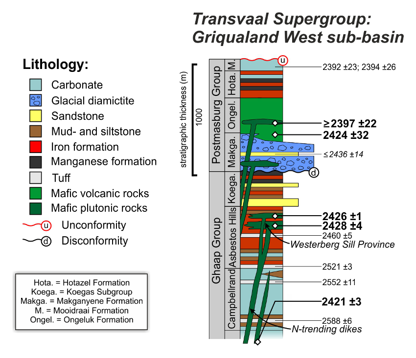
Figure: 1 – The stratigraphy of the upper Transvaal Supergroup as preserved in the Griqualand West sub-basin. Ages (in Mega-annum, Ma) are denoted for the stratigraphy, with ages of the Ongeluk LIP and its volcanic strata as well as its feeders: the N-trending dyke swarm and Westerberg Sill Province highlighted in bold font (modified after Gumsley et al., 2017).
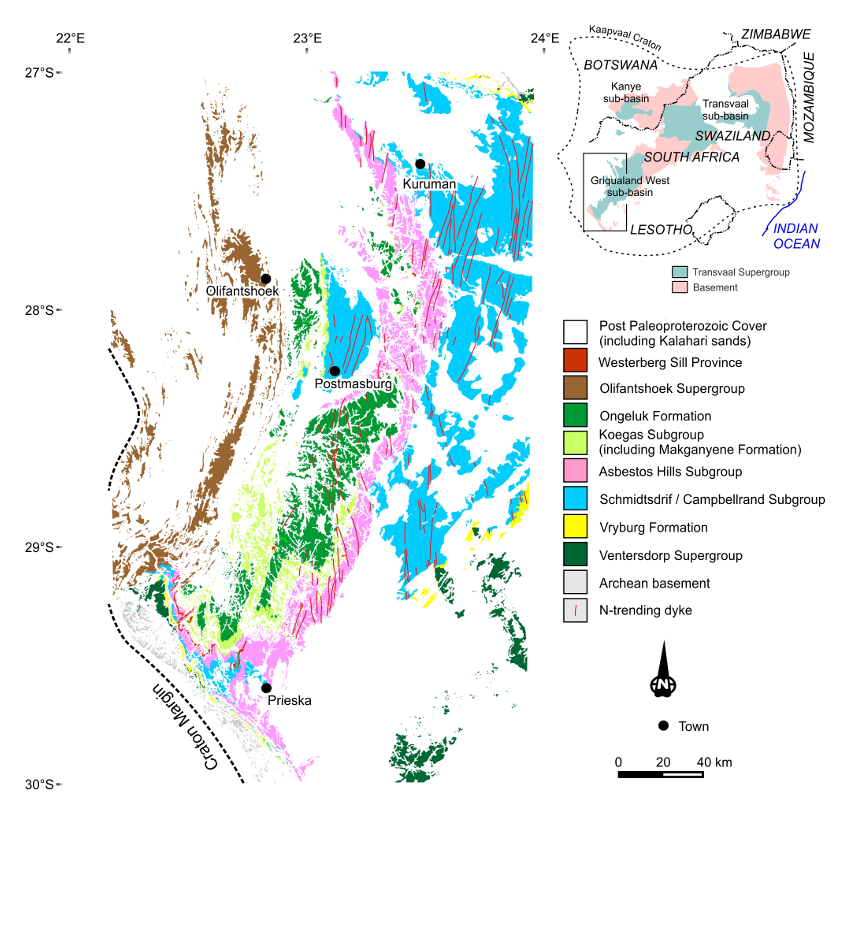
Figure: 2 – Geological map of the Griqualand West sub-basin, illustrating the Ongeluk Formation as well as the Westerberg Sill Province and N-trending dolerite dyke swarm within the Transvaal Supergroup (modified after Kampmann et al., 2015). An inset map shows the position of the three sub-basins of the Transvaal Supergroup relative to the Kaapvaal Craton within southern Africa.
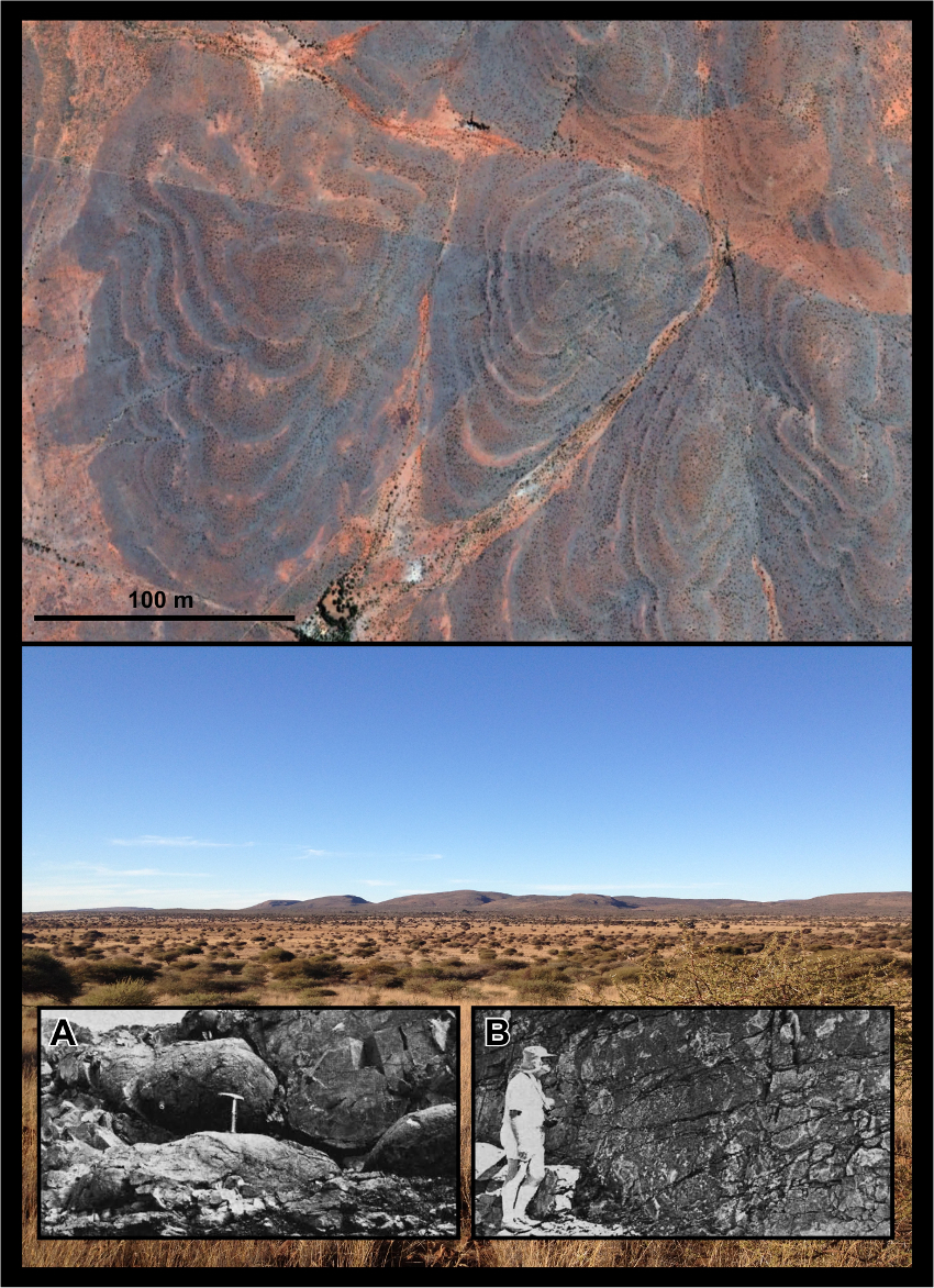
Figure: 3 – Top: lava flows of the Ongeluk Formation observed from Google Earth in the Northern Cape Province. Bottom: The Asbestos Hills and subsequent subgroups of the Transvaal Supergroup rising up above the dolomites of the Campbellrand and Schmidtsdrif subgroups near Kuruman. Inset: A – Pillow lavas of the Ongeluk Formation near Bosch Aar and B – Hyaloclastite in the same locality. Taken from Grobler and Botha (1976).
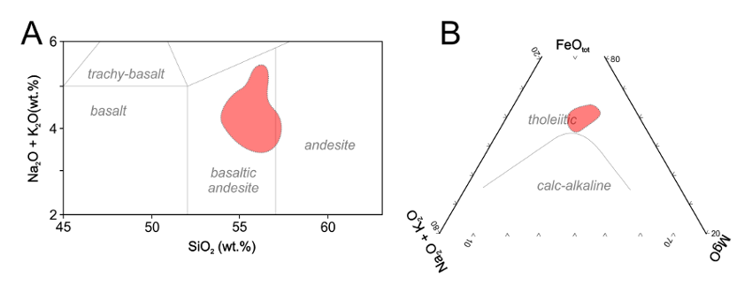
Figure: 4 – A) TAS diagram of Le Bas et al. (1992) for the geochemistry of the Ongeluk Formation lavas and B) an AFM diagram of Irvine and Baragar (1971) showing compositions for the Ongeluk Formation from Cornell et al. (1996) and Schütte, 1992).
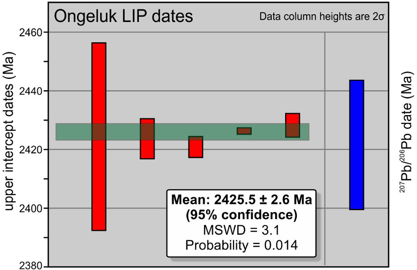
Figure: 5 – Six Ongeluk LIP dates defining a new ca. 2426 Ma large igneous province on the Kaapvaal Craton (Gumsley et al., 2017).
Acknowledgments
The geochronological studies on the Ongeluk large igneous province came through a sub-project of the nearly completed Ph.D project of Ashley Gumsley entitled: ‘Validating the existence of Vaalbara in the Mesoarchean to Paleoproterozoic’. Ashley Gumsley gratefully acknowledges the support provided principally by Ulf Söderlund and Michiel de Kock as supervisors, as well as other researchers involved in this particular research sub-project: Kevin Chamberlain, Wouter Bleeker, Andrey Bekker, Emilie Larsson and Tobias Kampmann, without whose help this would project would not have been finally realized. Financial assistance was provided by the Swedish Research Council to Ulf Söderlund, the Royal Physiographic Society in Lund to Ashley Gumsley, as well as the Industry-sponsored Supercontinent Project through to Richard Ernst and Wouter Bleeker (www.supercontinent.org).
Click to open/close ReferencesReferences
Alebouyeh Semami, F., de Kock, M.O., Söderlund, U., Gumsley, A.P., da Silva, R., Beukes, N.J., Armstrong, R.A., 2016. New U–Pb geochronologic and palaeomagnetic constraints on the late Palaeoproterozoic Hartley magmatic event: evidence for a potential large igneous province in the Kaapvaal Craton during Kalahari assembly, South Africa. GFF 138, 164–182.
Altermann, W., Hälbich, I.W., 1990. Thrusting, folding and stratigraphy of the Ghaap Group along the southwestern margin of the Kaapvaal Craton. South African Journal of Geology 93, 553–566.
Armstrong, R.A., 1987. Geochronological studies on Archean and Proterozoic formations of the Namaqua front and possible correlates on the Kaapvaal Craton. Ph.D thesis (unpublished) University of the Witwatersrand.
Bau, M., Romer, R.L., Lüders, V., Beukes, N.J., 1999. Pb, O, and C isotopes in silicified Mooidraai dolomite (Transvaal Supergroup, South Africa): implications for the composition of Paleoproterozoic seawater and “dating” the increase of oxygen in the Precambrian atmosphere. Earth and Planetary Science Letters 174, 43–57.
Beukes, N.J., Dorland, H., Gutzmer, J., Nedachi, M., Ohmoto, H., 2002. Tropical laterites, life on land, and the history of atmospheric oxygen in the Paleoproterozoic. Geology 30, 491–494.
Beukes, N.J., Smit, C.A., 1987. New evidence for thrust faulting in Griqualand West, South Africa; implications for stratigraphy and the age of red beds. South African Journal of Geology 90, 378–394.
Bleeker, W., 2003. The late Archean record: A puzzle in ca. 35 pieces. Lithos 71, 99–134.
Cornell, D.H., Schütte, S.S., Eglington, B.L., 1996. The Ongeluk basaltic andesite formation in Griqualand West, South Africa: submarine alteration in a 2222 Ma Proterozoic sea. Precambrian Research 79, 101–123.
de Kock, M.O., Evans, D.A.D., Kirschvink, J.L., Beukes, N.J., Rose, E., Hilburn, I., 2009. Paleomagnetism of a Neoarchean-Paleoproterozoic carbonate ramp and carbonate platform succession (Transvaal Supergroup) from surface outcrop and drill core, Griqualand West region, South Africa. Precambrian Research 169, 80–99.
Dixon, R., 1988. Sugilite and associated metamorphic silicate minerals from Wessels Mine Kalahari Manganese Field. M.Sc thesis (unpublished) University of Cape Town.
Dorland, H.C., 2004. Provenance Ages and Timing of Sedimentation of Selected Neoarchean and Paleoproterozoic Successions on the Kaapvaal Craton. Ph.D thesis (unpublished) Rand Afrikaans University.
du Toit, A.L., 1926. The Geology of South Africa. Oliver and Boyd, Edinburgh.
Ernst, R., 2014. Large igneous provinces. Cambridge University Press: Cambridge.
Ernst, R., Bleeker, W., 2010. Large igneous provinces (LIPs), giant dyke swarms, and mantle plumes: significance for breakup events within Canada and adjacent regions from 2.5 Ga to the Present. Canadian Journal of Earth Science 47, 695–739.
Ernst, R.E., Youbi, N., 2017. How Large Igneous Provinces affect global climate, sometimes cause mass extinctions, and represent natural markers in the geological record. Palaeogeography, Palaeoclimatology, Palaeoecology (in press)
Evans, D.A., Beukes, N.J., Kirschvink, J.L., 1997. Low-latitude glaciation in the Palaeoproterozoic era. Nature 386, 262–266.
Fairey, B., Tsikos, H., Corfu, F., Polteau, S., 2013. U-Pb systematics in carbonates of the Postmasburg Group, Transvaal Supergroup, South Africa: Primary versus metasomatic controls. Precambrian Research 231, 194-205.
Grobler, N.J., Botha, B.J.V., 1976. Pillow-lavas and hyaloclastite in the Ongeluk Andesite Formation in a road-cutting west of Griquatown, South Africa. Transactions of the Geological Society of South Africa 79, 53–57.
Gumsley, A.P., Chamberlain, K.R., Bleeker, W., Söderlund, U., de Kock, M.O., Larsson, E.R., Bekker, A., 2017. Timing and tempo of the Great Oxidation Event. Proceedings of the National Academy of Sciences of the U.S.A. 114, 1811–1816.
Gumsley, A.P., Rådman, J., Söderlund, U., Klausen, M.B., 2016. U–Pb baddeleyite geochronology and geochemistry of the White Mfolozi Dyke Swarm: unravelling the complexities of 2.70–2.66 Ga dyke swarms across the eastern Kaapvaal Craton, South Africa. GFF 138, 115–132.
Gutzmer, J., Pack, A., Luders, V., Wilkinson, J., Beukes, N., van Niekerk, H., 2001. Formation of jasper and andradite during low-temperature hydrothermal seafloor metamorphism, Ongeluk Formation, South Africa. Contributions to Mineralogy and Petrology 142, 27–42.
Irvine, T.N., Baragar, W.R.., 1971. A Guide to the Chemical Classification of the Common Volcanic Rocks. Canadian Journal of Earth Science 8, 523–548.
Kampmann, T.C., Gumsley, A.P., de Kock, M.O., Söderlund, U., 2015. U-Pb geochronology and paleomagnetism of the Westerberg Sill Suite, Kaapvaal Craton - Support for a coherent Kaapvaal-Pilbara Block (Vaalbara) into the Paleoproterozoic? Precambrian Research 269, 58–72.
Kirschvink, J.L., Gaidos, E.J., Bertani, L.E., Beukes, N.J., Gutzmer, J., Maepa, L.N., Steinberger, R.E., 2000. Paleoproterozoic snowball Earth: Extreme climatic and geochemical global change and its biological consequences. Proceedings of the National Academy of Sciences of the U.S.A. 97, 1400–1405.
Le Bas, M.J., Le Maitre, R.W., Woolley, A.R., 1992. The construction of the Total Alkali-Silica chemical classification of volcanic rocks. Mineralogy and Petrology 46, 1–22.
Melezhik, V.A., Young, G.M., Eriksson, P.G., Altermann, W., Kump, L.R., Lepland, A., 2013. Huronian-Age Glaciation, in: Melezhik, V.A., Kump, L.R., Strauss, H., Prave, A.R. (Eds.), Reading the Archive of Earth’s Oxygenation. Springer, Heidelberg, pp. 1059–1109.
Moore, J.M., Polteau, S., Armstrong, R.A., Corfu, F., Tsikos, H., 2012. The age and correlation of the Postmasburg Group, southern Africa: Constraints from detrital zircon grains. Journal of African Earth Sciences 64, 9–19.
Moore, J.M., Tsikos, H., Polteau, S., 2001. Deconstructing the Transvaal Supergroup, South Africa: implications for Palaeoproterozoic palaeoclimate models. Journal of African Earth Sciences 33, 437–444.
Pickard, A.L., 2003. SHRIMP U-Pb zircon ages for the Palaeoproterozoic Kuruman Iron Formation, northern Cape Province, South Africa: Evidence for simultaneous BIF deposition on Kaapvaal and Pilbara cratons. Precambrian Research 125, 275–315.
Polteau, S., Moore, J.M., Tsikos, H., 2006. The geology and geochemistry of the Palaeoproterozoic Makganyene diamictite. Precambrian Research 148, 257–274.
Schütte, S.S., 1992. Ongeluk volcanism in relation to the Kalahari manganese deposits. Ph.D thesis (unpublished) University of Natal.
Stow, G.W., 1874. Geological notes upon Griqualand West. Quaterley Journal of the Geological Society 30, 581–680.