December 2017 LIP of the Month
The Ferrar LIP: Field and geochemical constraints on the high-level magma emplacement.
David H. Elliot, School of Earth Sciences and Byrd Polar Research Center, Ohio State University, Columbus, OH 43210; email: elliot.1@osu.edu
Thomas H. Fleming, Department of Earth Sciences, Southern Connecticut State University, New Haven, CT 06515
This is an abridged version of Elliot & Fleming (2017), which can be found online at:
http://sp.lyellcollection.org/online-first/463 and after publication, projected to be March 2018 at:
http://sp.lyellcollection.org/content/463/1
The Ferrar Large Igneous Province (FLIP), in outcrop, has a narrow linear distribution for 3250 km across Antarctica from the Theron Mountains to north Victoria Land (NVL), and extending for another 500 km and diverging to a width of about 1500 km to encompass New Zealand, Tasmania, and southeastern Australia (Fig. 1). Intrusive rocks comprise the Ferrar Dolerite sills and minor dykes (Elliot & Fleming 2004), and the Dufek layered mafic intrusion (Ford & Himmelberg 1991). The sills, generally between 100 and 200 m and with cumulative thicknesses of ~1500 m, occur mainly in the 2.0-2.5-km-thick Devonian-Triassic Beacon Supergroup (Collinson et al. 1994; Bradshaw 2013) (Fig. 2). The sills, excluding outliers at and near Horn Bluff, occur in a nearly continuous outcrop belt extending for about 2000 km from NVL to the Ohio Range, and intermittently for a further 1300 km to the Theron Mountains. Dykes are not common, but intrude both basement rocks and the Beacon sequence. Extrusive components of the FLIP consist of basaltic pyroclastic rocks overlain by the Kirkpatrick Basalt lavas (Fig. 3), which attain a maximum extant thickness of ~700 m (Elliot & Fleming 2008). Intrusive rocks form 99% of the Ferrar outcrops and have an estimated volume of ~1.7×10⁵ km3, whereas extrusive rocks, with an estimated extant volume of ~7000 km3, form widely spaced remnants of once more extensive lava fields (Fleming et al. 1995).
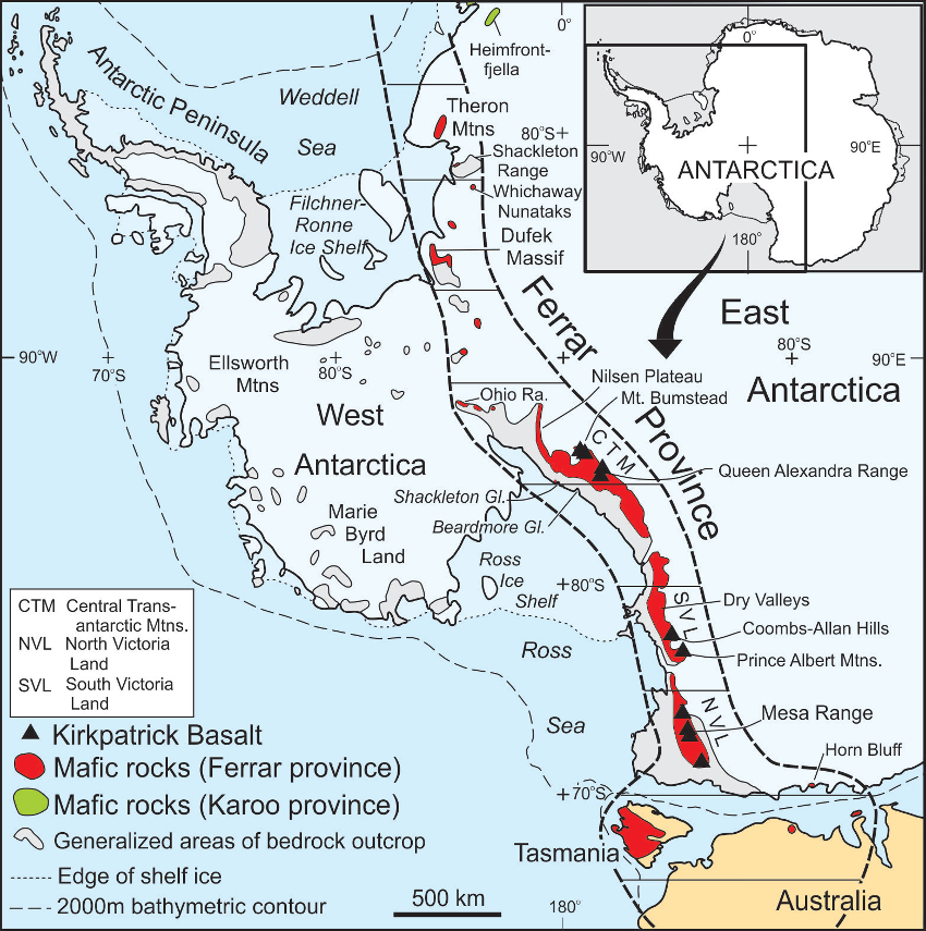
Figure 1. Distribution of the Ferrar Large Igneous Province. The original extent of the Ferrar province is speculative.
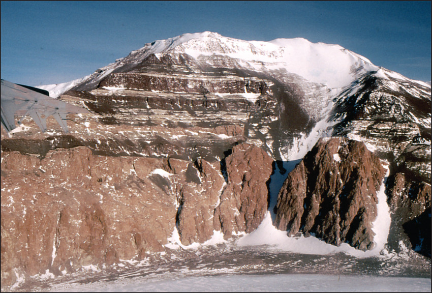
Figure 2. Dolerite sills intruding Beacon strata, which overlie Lower Paleozoic granite at spot height 3120, Nilsen Plateau (Fig. 1). Mountain face is about 1000 m high.
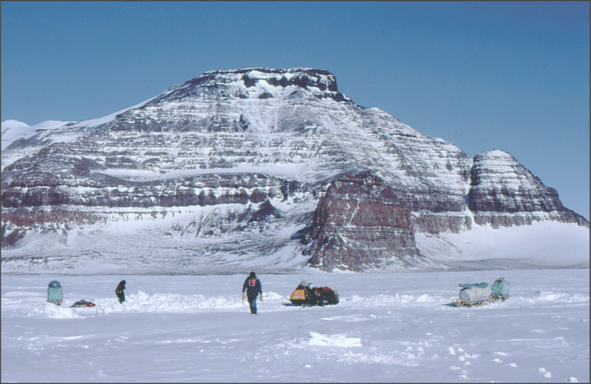
Figure 3. Kirkpatrick Basalt lavas at Mt. Frustum, Mesa Range, north Victoria Land. Black cliff at the summit is the SPCT flow. Mountain face is about 800 m high.
Geochemistry and age
The unifying characteristic of the FLIP is its distinctive geochemistry. Ferrar rocks have enriched Sr and Nd initial isotope ratios (Fig. 4) and crust-like trace element patterns (Fig. 5). The FLIP is separated into the Mount Fazio Chemical Type (MFCT) and the Scarab Peak Chemical Type (SPCT) (Fleming et al. 1992) (Table 1). The MFCT comprises 99% of the province and includes the majority of all analyzed rocks. The SPCT occurs as the stratigraphically youngest lava flow(s) in the central Transantarctic Mountains, south Victoria Land (SVL) and NVL, and also as sills in the Theron Mountains and the Whichaway Nunataks (Fig. 1) (Brewer et al. 1992; Leat et al. 2006).
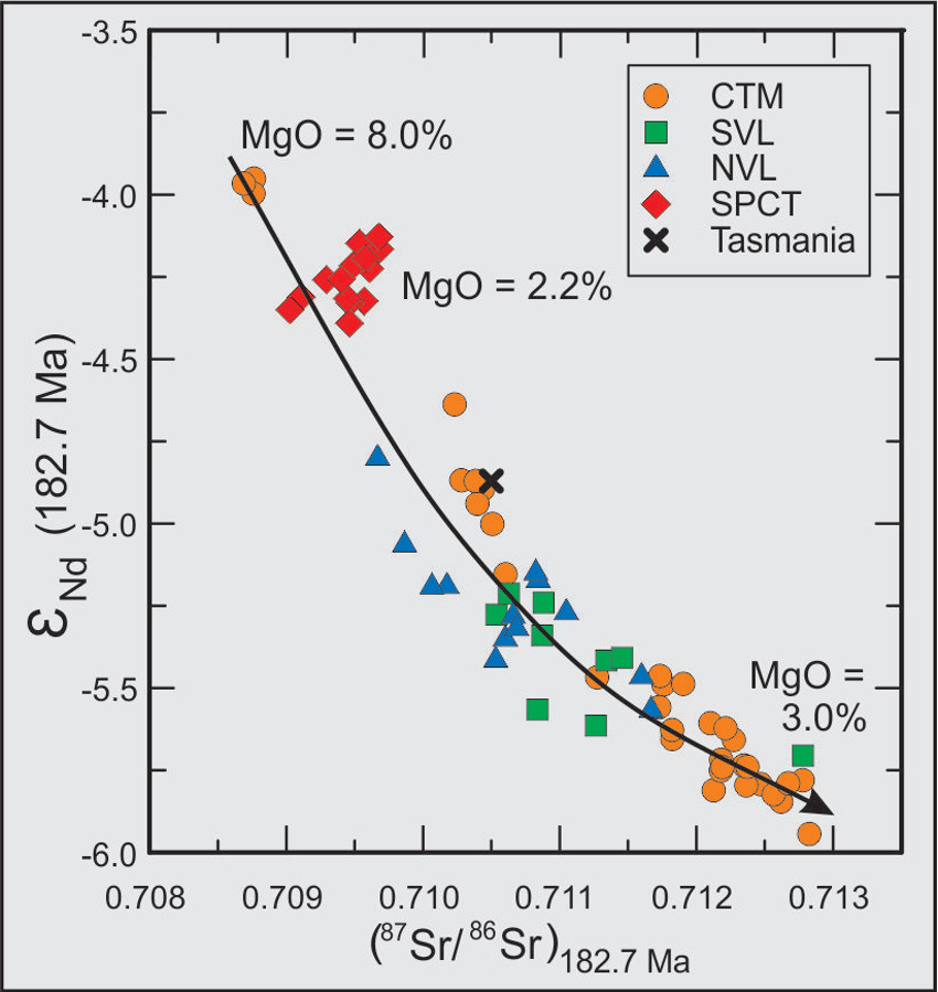
Figure 4. εnd versus 87Sr/ 87Sr at 183 Ma for Ferrar Large Igneous Province sills and lavas (Elliot & Fleming 2017, fig, 4).
Table 1. Representative major element analyses of Ferrar sills and lavas (Elliot & Fleming 2017, table 1).
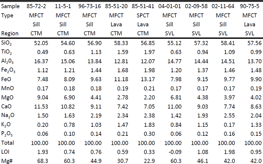
Analyses performed by EDXRF at Southern Connecticut State University and WDXRF at New Mexico Tech using a Li-metaborate fusion methologies modified after Norrish and Hutton (1969). Major Element analyses given in weight percent and normalized to 100% loss-free with Fe2O3/FeO=0.15. CTM: central Transantarctic Mountains; NVL: north Victoria Land; SVL: south Victoria Land. Sample locations and additional analyses can be found in Elliot & Fleming (2017).
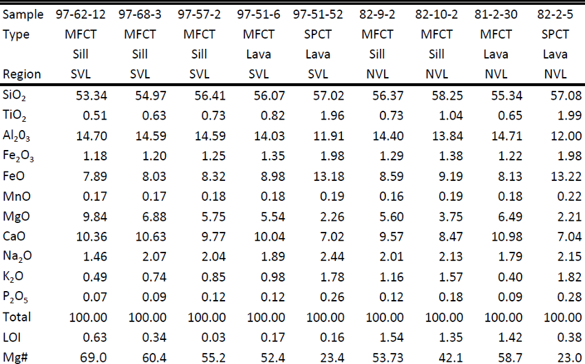
Figure 5. MORB-normalized trace element diagram for selected samples of the Ferrar Group (fElliot & Fleming 2017, fig. 5). The samples cover the entire range of MgO concentrations observed. Normalization factors from Sun & McDonough (1989).
The MFCT rocks exhibit a continuous range of chemical and isotopic variations (87Sr/86Sri ~0.709-0.712; MgO ~9.3-2.6 %; Zr ~60-175 ppm) which can be attributed to fractional crystallization accompanied by ∼5% crustal assimilation (Figs. 4, 5, 6) (Fleming et al. 1995). Only data collected by the authors are presented here; analyses of Ferrar sills in SVL and NVL by other investigators (see Elliot & Fleming 2017) show that all belong to the MFCT and do not change the compositional range except for a few NVL samples, which are slightly more evolved. The SPCT has a distinct and restricted composition (Sri ~0.7095; MgO ~2.3%; Zr ~230 ppm), which lies off the chemical trends of the MFCT (Elliot et al. 1999).
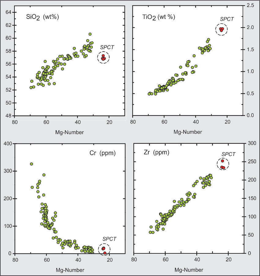
Figure 6. Variation diagrams for selected major and trace elements for Ferrar Group lavas and sills to illustrate the geochemical coherence of the MFCT and the restricted and different composition of the SPCT (Elliot & Fleming 2017, fig. 6).
The age and duration of magmatism have been determined by the single crystal CA-ID-TIMS method, which documented a restricted duration of emplacement (<0.4 Myr), ranging from 182.779 ± 0.033 Ma to 182.59 ± 0.079 Ma (2σ uncertainties) for the MFCT (Burgess et al. 2015). No clear temporal distinction exists between sills and lavas, although a limited number of analyses of SPCT rocks suggest that they are, permissibly, slightly younger (~182.43 ± 0.036 Ma).
Controls on shallow level (supra-crustal) emplacement.
Marsh (2004) examined the sills in the Dry Valleys of SVL and proposed that density provided the fundamental control on the emplacement level of Ferrar magmas. The principal control on density was interpreted to be the proportion of phenocrysts (primarily orthopyroxene) in the magmas. In this hypothesis, the least dense, crystal-free magmas (proxied by MgO content) were initially emplaced as lavas through a system of regional dykes. The magmatic system then delivers increasingly dense magmas from depth. In time, the magmas become too dense for eruption and are then emplaced as sills at progressively greater depths with progressively increasing density (MgO content). Marsh (2004) cited the lavas at Coombs Hills, and the sills in the Dry Valleys, as exemplifying this process. Ideally, the model predicts the lavas should exhibit increasing MgO up section and the sills increasing MgO down through the sill complex.
Airoldi et al. (2012) and Muirhead et al. (2012, 2014) examined dykes, inclined sheets, and sills in SVL, and proposed a different emplacement mechanism. On the basis of structural and magnetic studies, they suggested the Ferrar dykes (randomly oriented at Allan Hills) and sheets were intruded in a neutral stress field, not an extensional stress field. The dykes and inclined sheets formed the magma pathways from one sill to another and eventually to the surface for eruption as lavas. Thus a neutral stress field and sill inflation play a critical role in magma ascent, leading to a sill-fed dyke-network overlain by lavas supplied by the underlying dyke field. This scenario forms the “cracked-lid” hypothesis for flood basalt eruption (Muirhead et al. 2014), in which magma is transported via dykes in crustal rocks prior to invasion of supracrustal strata; this necessarily implies a regional stress field affecting the igneous and metamorphic basement. Further, a direct link should exist between lava and underlying sill compositions.
Stratigraphic and geochemical relationships (see Elliot & Fleming, 2017)
The stratigraphic distribution of sills illustrated in Figs 7, 8, and 9 is based on their occurrence through the Beacon Supergroup but does not necessarily represent simple vertical stacks. The sill and lava succession may be spread out geographically over a distance of 100 km or more (see Elliot & Fleming 2017) for details.

Figure 7. Schematic column to show the distribution of Ferrar Dolerite sills in the Victoria Group of the Beacon Supergroup in the Queen Alexandra Range and stratigraphic columns for Kirkpatrick Basalt lavas at Mt. Kirkpatrick and Storm Peak, both in the Queen Alexandra Range (Elliot & Fleming 2017, fig. 7b). The plotted points (in Figs, 7, 8 & 9) are the MgO concentrations of chilled margins of sills and of fine grained lavas. In this and other figures, sills are projected onto the stratigraphic column and do not represent a single vertical sequence.
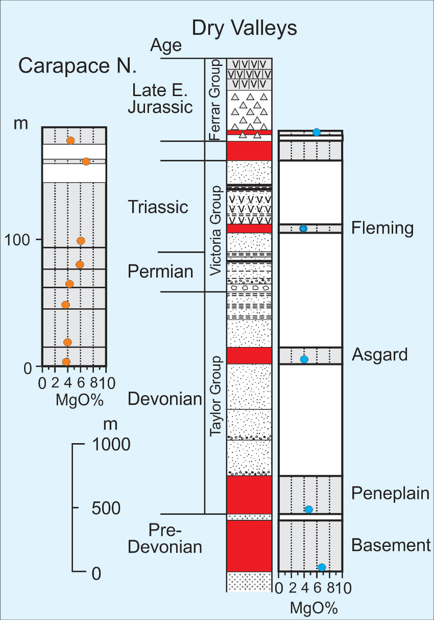
Figure 8. Schematic column to show the distribution of Ferrar Dolerite sills in the basement rocks and the Beacon Supergroup (Taylor and Victoria groups) in the Dry Valleys of south Victoria Land and a stratigraphic column for Kirkpatrick Basalt lavas at Carapace Nunatak, adjacent to the Coombs-Allan Hills region (Elliot & Fleming 2017, fig. 9a).
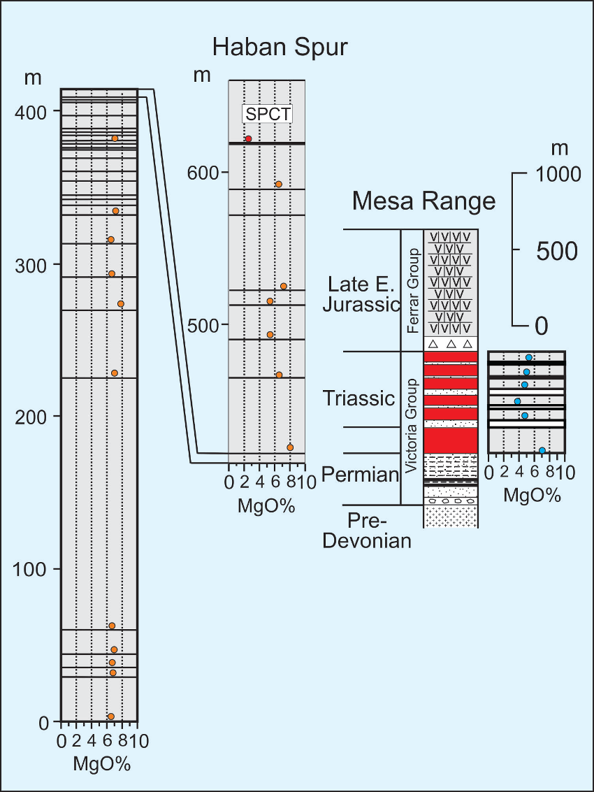
Figure 9. Schematic column to show the distribution of Ferrar Dolerite sills in the Beacon Supergroup in the Mesa Range region of north Victoria Land and a stratigraphic column for Kirkpatrick Basalt lavas at Haban Spur, Mesa Range (Elliot & Fleming 2017, fig. 11). The stratigraphic column is broken because there is no continuity between the Permian and Triassic strata.
The MgO concentrations of chilled margins of sills are plotted adjacent to the stratigraphic columns. Those of fine-grained lavas in the same regions are plotted on the same figures but at a different scale (the SPCT magma type is indicated where present). In the Queen Alexandra Range (Fig. 7) the sills are relatively high in MgO (6.0-9.4%), but with no trend and with the most MgO-rich olivine dolerite sills intruded into the upper part of the Permian section. Two lava columns, 38 km apart, are illustrated. Both begin with a very thin flow with MgO > 7.0%. At Storm Peak overlying lavas are much more evolved (MgO = 2.6-5.7%) and lack any clear trend. At Mt. Kirkpatrick four thick flows above the basal lava show an initial trend to greater MgO compositions.
In the Dry Valleys (Figs. 8) the sills are progressively higher in MgO down section (note exceptions below). The nearest lavas occur about 100 km to the NNW at Carapace Nunatak, and those flows, excepting the summit flow, show increasing MgO up section (an SPCT flow is absent). Dolerite plugs and a thin sill invade basaltic pyroclastic rocks at Coombs Hills (Ross et al. 2008); all have MgO >6.3%.
In NVL (Figs. 9), Beacon strata are widely scattered (250 km linear distribution). To the south and west of the Mesa Range, sills are confined to Triassic-Jurassic beds, but to the north sills intrude Permian beds. North of the Mesa Range, chilled margin compositions (MgO = 7.1-7.2%) are available for only three sills. One of these is 300 m thick and possibly occurs at or near the top of the Permian section (illustrated as such in Fig. 9). Several sills in Triassic-Jurassic beds are exposed in a nunatak adjacent to the southern Mesa Range and these have MgO = 3.7-5.6%. The analyzed sill samples to the south of the Mesa Range all have MgO <4.5%. The Mesa Range Kirkpatrick lavas are predominantly more MgO-rich (mainly 6-8% MgO, with just two at ~5% MgO) than sills at Exposure Hill and south of the Mesa Range; the lava sequence shows no trend up section.
The sills at Section Peak are thick and uniform, and together with the sills at Exposure Hill show no sign of shallow intrusion such as vesicularity. Thus the lavas, which generally have greater MgO than the sills, were probably erupted first in order for sufficient overburden to be present for sills to lack signs of degassing.
Discussion
The relationship implied by the density-driven vertical-emplacement hypothesis (Marsh, 2004) is not observed in NVL (Fig. 9). There is no clear pattern in the Prince Albert Mountains that would support the hypothesis, whereas in the Dry Valleys region the geochemistry in general is not inconsistent with it (Fig. 8). In the Queen Alexandra Range (Fig. 7), apart from the high-MgO basal flow, the lavas at Mt. Kirkpatrick and Storm Peak partially support the hypothesis. The sills, however, show no pattern of increasing MgO with depth. Similarly in the Shackleton Glacier region, apart from the very thick basal flow at Mt. Bumstead, the lavas are uniformly strongly evolved. The sills have greater MgO except for three with MgO ~4.5%, but there is no pattern. In summary, the geochemistry is not inconsistent with the density-driven hypothesis in the Dry Valleys, but appears to contradict the hypothesis in NVL and shows inconsistent patterns in the three other regions. Factors other than magma density must play a significant role in the emplacement of magmas either at depth or at the surface.
In the cracked-lid sill-fed hypothesis (Muirhead et al. 2014), some geochemical correlation between the lava flows and the sills should exist. Further, this hypothesis implies that sill conduits are developed before magmas erupt; lava flow eruption should be accompanied by corresponding magma emplacement at depth. In the Queen Alexandra Range, given that the sills have higher MgO than the lava flows, it is possible that the evolved lavas might be the products of magma evolution in sill bodies. However, most sills lack significant in situ differentiation and no sill shows evidence (layering and accumulation of plagioclase and mafic minerals) for the extended fractional crystallization required to produce the evolved lavas (individual flows up to ~200 m thick), nor are there any sills with the evolved lava compositions that could be considered constituent parts of the conduit systems. Further, an orthopyroxene mush comparable to that of the Basement Sill in SVL, a critical factor in the density-driven hypothesis, is not known to be present in any sill elsewhere. In SVL the range of lava and sill compositions is compatible with direct connections between them, and the same is the case in the Prince Albert Mountains. In NVL the geochemistry is marginally consistent with a connection between the lava flows and sills north of the Mesa Range.
In evaluating these hypotheses, uncertainties arise because sills and lavas in any one assessed area crop out as much as 100 km apart. Further, many factors must affect the emplacement of magmas, whether as sills or lava flows. These include density, lithostatic pressures, magma overpressures required for lateral emplacement, wall rock composition and physical properties, and when and where the evolving source was tapped.
The SPCT magma composition provides an important perspective on the relationship between the intrusive and extrusive elements of the Ferrar magmatic system. Among the lavas it is represented only by the uppermost flow(s). No analyzed sill between Mt Spann (Fig. 2) and NVL (nor in Australasia) has SPCT composition, although such is present in the Theron Mountains and Whichaway Nunataks (Fig. 1), which are 1250 km from the nearest extant lava in the Mt. Bumstead region. SPCT lavas share chemical characteristics with MFCT rocks, such as enriched initial isotope ratios of Sr and Nd, and crust-like trace element patterns. However, they had a different evolutionary path because their evolved major and trace-element geochemistry (Fig. 4) is accompanied by Sr and Nd initial isotope ratios that lie at the least evolved end of the Ferrar province range (Fig. 2). SPCT rocks are not compatible with the density-driven hypothesis nor with the sill-fed cracked-lid hypothesis (Muirhead et al. 2014); they clearly demand a different emplacement path that has yet to be identified.
Conclusions
Two scenarios have been proposed to explain the shallow emplacement history, one driven by magma physical properties (density) (Marsh 2004) and the other driven by sill inflation in a neutral stress field (Muirhead et al. 2012, 2014). Evidence from SVL is not inconsistent with the density-driven emplacement mechanism (Marsh 2004). At the other localities, field and geochemical data are inconsistent with the hypothesis. Field and geochemical data do not support the sill-fed hypothesis (Muirhead et al. 2014) as a geographically widespread scenario. Each process may be of local importance but neither hypothesis, based on field and geochemical data, applies province-wide.
Acknowledgments The authors acknowledge considerable support from the Office of Polar Programs, National Science Foundation.
Click to open/close ReferencesReferences
Airoldi, G., Muirhead, J. D., Zanella, E. & White, J. D. L. 2012. Emplacement process of Ferrar Dolerite sheets at Allan Hills (South Victoria Land, Antarctica) inferred from magnetic fabric. Geophysical Journal International, 188, 1046-1060, doi: 10.1111/j.1365-246X.2011.05334.x.
Bradshaw, M. A. 2013. The Taylor Group (Beacon Supergroup): the Devonian sediments of Antarctica. In: Hambrey, M. J., et al. (eds) Antarctic Palaeoenvironments and Earth-Surface Processes. Geological Society, London, Special Publications, 381, p. 67-97, doi.org/10.1144/SP381.23.
Brewer, T. S., Hergt, J. M., Hawkesworth, C. J., Rex, D. & Storey, B. C. 1992. Coats Land dolerites and the generation of Antarctic continental flood basalts. In: Storey, B. C., King, E. C. & Livermore, R. A. (eds) Magmatism and the Causes of Continental Break-up. Geological Society, London, Special Publications, 68, p. 185-208.
Burgess, S. D., Bowring, S. A., Fleming, T. H. & Elliot, D. H. 2015. High precision geochronology links the Ferrar Large Igneous Province with early Jurassic ocean anoxia and biotic crisis. Earth and Planetary Science Letters, 415, p. 90-99, doi:10.1016/j.epsl.2015.01.037.
Collinson, J. W., Elliot, D. H., Isbell, J. L. & Miller, J.M.G. 1994. Permian-Triassic Transantarctic Basin. In: Veevers, J. J. & Powell, C. McA. (eds) Permian-Triassic Pangaean Basins and Foldbelts along the Panthalassan margin of Gondwanaland. Geological Society of America, Boulder, CO, Memoirs, 184, 173-222.
Elliot, D. H. & Fleming, T. H. 2004. Occurrence and dispersal of magmas in the Jurassic Ferrar Large Igneous Province, Antarctica. Gondwana Research, 7, 223-237.
Elliot, D. H. & Fleming, T. H. 2008. Physical volcanology and geological relationships of the Ferrar Large Igneous Province, Antarctica. Journal of Volcanology and Geothermal Research, 172, 20-37.
Elliot, D. H. & Fleming, T. H. 2017. The Ferrar large Igneous Province: field and geochemical constraints on supra-crustal (high-level) emplacement of the magmatic system. In: Sensarma, S. & Storey, B.C. (eds) Large Igneous Provinces from Gondwana and Adjacent Regions. Geological Society, London, Special Publications, 463, https://doi.org/10.1144/SP463.1
Elliot, D. H., Fleming, T. H., Kyle, P. R. & Foland, K. A. 1999. Long Distance Transport of Magmas in the Jurassic Ferrar Large Igneous Province, Antarctica. Earth and Planetary Science Letters, 167, 87-104.
Fleming, T. H., Foland, K. A. & Elliot, D. H. 1995. Isotopic and chemical constraints on the crustal evolution and source signature of Ferrar magmas, North Victoria Land, Antarctica. Contributions to Mineralogy and Petrology, 121, 217-236.
Fleming, T. H., Elliot, D. H., Jones, L. M., Bowman, J. R. & Siders, M. A. 1992. Chemical and isotopic variations in an iron-rich lava flow from North Victoria Land, Antarctica: Implications for low-temperature alteration and the petrogenesis of Ferrar magmas. Contributions to Mineralogy and Petrology, 111, 440-457.
Ford, A. B. & Himmelberg, G. R. 1991. Geology and crystallization of the Dufek intrusion. In: Tingey, R.J. (ed.). The Geology of Antarctica. Oxford Monographs on Geology and Geophysics. Oxford University Press, Oxford, 17, 175-214.
Leat, P. T., Luttinen, A. V., Storey, B. C. & Millar, I. L. 2006. Sills of the Theron Mountains, Antarctica: evidence for long distance transport of mafic magmas during Gondwana break-up. In: Hanski, E., Mertanen, S., Rämö, T. & Vuollo, J. (eds) Dyke swarms: Markers of Crustal Evolution. Taylor and Francis, Abingdon, p. 183-199.
Marsh, D. B. 2004. A magmatic mush column Rosetta Stone: The McMurdo Dry Valleys of Antarctica. Eos, 86(47), 497, 502.
Muirhead, J. D., Airoldi, J., Rowland, J. V. & White, J. D. L. 2012. Interconnected sills and inclined sheet intrusions control shallow magma transport in the Ferrar large igneous province, Antarctica. Bulletin of the Geological Society of America, 124, 162-180, doi: 10.1139/B30455.1
Muirhead, J. D., Airoldi, G., White, J. D. L. & Rowland, J. V. 2014. Cracking the lid: Sill-fed dikes are the likely feeders of flood basalt eruptions. Earth and Planetary Science Letters, 406, 187-197, doi.org/10.1016/j.epsl.2014.08.036.