November 2016 LIP of the Month
Magnetic characterization of the High Arctic Large Igneous Province using pseudogravity analysis
Gordon N. Oakey1, Richard W. Saltus2
1 Geological Survey of Canada (Atlantic), PO 1006, B2Y 4A2 Dartmouth, NS, Canada – Gordon.Oakey@Canada.ca
2 NOAA/NCEI, Boulder, CO 80305 – Rick.Saltus@NOAA.gov
For full details see Oakey and Saltus (2016), from which this LIP of the Month has been extracted and modified.
The High Arctic Magnetic High Domain (HAMH) is a large region of “chaotic” magnetic anomalies associated with the volcanic Alpha–Mendeleev ridge complex – a significant component of the High Arctic Large Igneous Province (HALIP). We apply a Fourier-domain inversion to convert the dipole-sourced magnetic data to a monopole and calculate the magnetic potential (a.k.a. pseudogravity). This methodology enhances magnetic structures with deep crustal roots. It does not, however, differentiate between positively or negatively oriented magnetic sources. A closed contour around this “pseudogravity” anomaly quantifies the aerial extent of the HAMH at ~1.3 × 10⁶ km2. The HAMH extends beyond the Alpha–Mendeleev bathymetric high beneath the sediment cover of the adjacent sedimentary basins (Canada Basin, Makarov–Podvodnikov basins and Chukchi Basin). The edge of the HAMH within the Makarov Basin is coincident with the Marvin Spur. The HAMH also extends onto the Canadian Polar Margin and includes a portion of coastal Ellesmere Island.
Forward 2D modeling of the magnetic data show that high amplitude magnetization values are required – values which exceed typical ranges for induced magnetization of volcanic rocks. We conclude that there is a significant component of (normal) remanent magnetization. The modeling confirms that the magnetic anomalies are not the result of magnetized bathymetric highs, but are caused by mid- and lower crustal sources. Volumetric estimates of the volcanic composition include (at least) 6 × 10⁶ km3 for the mid- and upper-crust and between 13 × 106 and 17 × 106 km3 within the lower crust — for a total of ~20 × 106 km3.
We compare the magnetic character, pseudogravity, and volumetric estimates for the HAMH portion of the HALIP with global large igneous province analogs and discuss implications for Arctic tectonics. Our results show that the closest analog to the HAMH/HALIP is the Kerguelen Plateau, which is considered a continental plateau intensively modified by plume-related volcanism.
Overview
The High Arctic Large Igneous Province (HALIP) is a broadly used term that includes multiple phases of onshore/offshore Mesozoic and Early Cenozoic dykes, sills, flood basalts, caldera complexes and plutonic intrusives. Although there is a general consensus that the HALIP was the result of plume-sourced volcanism, the regional influence of the plume and its relationship with the timing of the opening of Amerasia Basin and the emplacement of the Alpha-Mendeleev Ridge complex is poorly understood.
In this summary, we highlight selected material on the magnetic modeling of the Alpha -Mendeleev Ridge that we recently published in Tectonophysics (Oakey and Saltus, 2016), which is available as an open-source publication.
Arctic Amerasia Basin Physiography
The Alpha and Mendeleev ridges are components of a 2000 km long and 200-400 km wide bathymetric high that extends from the Ellesmere Island portion of the Canadian Polar Margin to the East Siberian Shelf (Fig. 1). The ridges are two separately labeled oceanic features divided at a bathymetric low (~ 2700 mbsl) known as Cooperation Gap (Treshnikov et al, 1967).
The Lomonosov Ridge is a long (~1600 km) and narrow (typical width about 170 km) seafloor high (reaches submarine elevations above 1000 mbsl) separating the Eurasia Basin from the Amerasia Basin. The Lomonosov Ridge is a sliver of high standing continental crust that was separated from the Barents shelf as a result of Cenozoic seafloor spreading in the Eurasia Basin.
Between the Alpha-Mendeleev ridge complex and the Lomonosov Ridge lie the Makarov and Podvodnikov basins with seafloor depths greater than 3500 mbsl. The Chukchi Borderlands is a bathymetrically complex, high-standing seafloor feature situated between the Alpha-Mendeleev ridge complex and the Bering Sea Shelf. The Canada Basin is a large deep water region (depths greater than 3500 mbsl) bordered by the Alpha-Mendeleev ridge complex, the Canadian Polar Margin, the Chukchi Borderlands, and the Alaskan Polar Margin.
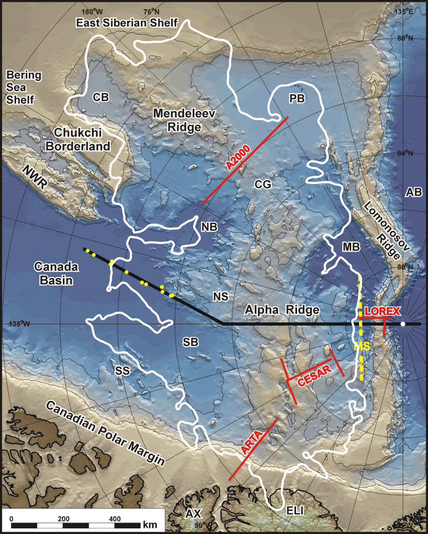
Figure 1: Bathymetry/topography of the study area. International Bathymetric Chart of the Arctic Ocean (IBCAO; Jakobsson et al., 2012). The outline of the High Arctic Magnetic High (HAMH, white polygon) is from Fig. 2. Heavy black line is the location of the 2D model shown in figure 3. Solid red lines show the locations of published transects across the Alpha and Mendeleev ridges discussed in the text: A2000 from Lebedeva-Ivanova et al. (2006); ARTA from Funck et al. (2011); CESAR from Forsyth et al. (1986); LOREX from Forsyth and Mair (1984). Yellow dots show locations of sonobuoy deployments (Chian and Lebedeva-Ivanova, 2015) used in the 2D model. The axis of Marvin Spur (MS) is shown with a yellow dotted line. AB = Amundsen Basin; AX = Axel Heiberg Island; CB = Chukchi Basin; CG = Cooperation Gap; ELI = Ellesmere Island; NB = Nautilus Basin; NS = Nautilus Spur; NWR = Northwind Ridge; MB = Makarov Basin; PB = Podvodnikov Basin; SB = Stefansson Basin; SS = Sever Spur.
Total Field Magnetic Anomaly
The magnetic anomaly data (Fig. 2A) show a distinctive domain of high-amplitude chaotic magnetic highs and lows over the Amerasia Basin with anomaly values from the Gaina et al. (2011) compilation ranging from -950 to +1370 nT. Saltus et al. (2011) classified this region as the “F1: Alpha-Mendeleev Large Igneous Province” (AMLIP) domain. We have re-defined the boundaries of this domain which we now call the “High Arctic Magnetic High” (HAMH) domain.
Pseudogravity (magnetic potential) – definition of the HAMH
To quantitatively define the outline of the HAMH and highlight the long-wavelength (and thus deeper) nature of the HAMH we use the pseudogravity transformation. Pseudogravity (also known as magnetic potential; see Blakely, 1995) is an alternate mathematical expression of total-field magnetic anomalies. This transformation is calculated in the Fourier frequency domain to convert the magnetic dipole to a monopole and a “magnetic density” is assigned to determine a magnetic potential.
The transformed field has depth-to-source dependence characteristics similar to that of gravity data (thus the term “pseudogravity”). The pseudogravity transformation “simplifies” the resulting field in two fundamental ways: (1) the transformation removes the asymmetric dipole effects of geomagnetic latitude on the form of anomaly patterns, and (2) the transformation changes the depth-to-source dependence from distance cubed to distance squared. For regional scale geologic interpretation and modeling, pseudogravity provides a greater emphasis on deeper portions of the crust and on thicker physical property domains versus standard total-field magnetic anomalies.
The resulting pseudogravity field is shown in Figure 2B. The parameters used in calculating the pseudogravity are a “replacement” of a magnetic field strength of 8.0 A/m with a density equivalent of 2670 kg/m3. Changing this ratio will effect the resulting pseudogravity amplitude ranges, but is only a linear scalar effect and does not impact the resulting geometry of the HAMH. The pseudogravity representation allows for a robust, repeatable, and quantifiable mapping of the HAMH domain boundary following a pseudogravity isoline (a closed contour around the high values) as shown in Figure 2B.
Association of the HAMH with the HALIP
We interpret the HAMH as a geophysical manifestation of the voluminous mafic intrusions and extrusions of the HALIP in the region surrounding and including the Alpha-Mendeleev ridge complex. A primary reason for this conclusion is the spatial coincidence of the geophysical domain and the known and inferred extent of LIP igneous geology for the Alpha-Mendeleev ridge complex (e.g., Maher, 2001).
The “F1” Alpha-Mendeleev Large Igneous Province (AMLIP) Domain described by Saltus et al. (2011) (Fig. 2A) was based on a qualitative assessment of high amplitude magnetic anomalies over Amerasia Basin and included a significant portion of Lomonosov Ridge, the shelf region of the Canadian Polar Margin, and the magnetic highs along the Canada Basin edge of the Chukchi Plateau (adjacent to Northwind Ridge). Our revised HAMH definition (Figs. 1 and 2) is based on a closed contour in the calculated magnetic potential (aka. pseudogravity), and represents the geographic area of the HALIP (~1.3 x 10⁶ km2) with a deep-crustal root. Using this definition, the Lomonosov Ridge is not included, the new boundary lies (approximately) along the Marvin Spur, and extends to onshore Ellesmere Island. The pseudogravity-defined HAMH does not include the high amplitude magnetic anomalies adjacent to Northwind Ridge – indicating that the magnetic sources of these features do not a have a deep-crustal root. The new HAMH Domain now includes a portion of the East Siberian Shelf, which was not part of the Saltus et al. (2011) F1-AMLIP domain.
On the Canada Basin flank of the Alpha Ridge, the HAMH boundary has two pronounced embayments: one within Nautilus Basin; the other within Stefansson Basin. These correspond with large negative magnetic lows (L1 and L2). We speculate that these magnetic lows are over non-magnetic (continental?) crustal blocks or possibly areas with reversed remanent magnetization. In the same context, another pseudogravity low over the Nautilus Spur (L3) may also be sourced by a block of non-magnetized (or negatively magnetized) crust.
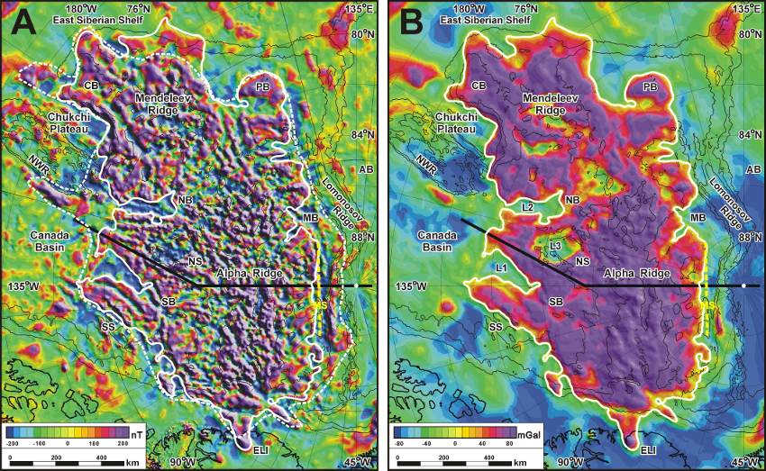
Figure 2: A) Magnetic anomaly of the study area (from CAMPM magnetic compilation, Gaina et al., 2011). Featured are the outline of the newly-defined HAMH domain boundary (thick white line) and the F1-AMLIP Domain (Saltus, et al., 2011; dashed white line). The location of the 2D model transect (thick black line) and the 1000 m bathymetric contours (thin black lines) are also shown. Abbreviated place names are from Fig. 1.. B) Pseudogravity (aka magnetic potential) was calculated using a Fourier-domain inversion method which converts the magnetic dipole source to a monopole source. The closed contour (isoline) of the pseudogravity covers an area of ~1.3 × 10⁶ km2. The two deeply incised “notches” (L1 and L2) observed in the Canada Basin side of the HAMH isoline boundary correspond with large negative magnetic anomalies (see Fig. 2A) and may represent areas with reverse polarity remanent magnetization. L3 = pseudogravity low over Nautilus Spur.
Magnetic Modelling of the Alpha Ridge
2-D forward magnetic models were constructed across the Alpha Ridge to determine the magnetization structure and estimate the volumetric content of the volcanic rocks that make up the HALIP. The models were constrained with available seismic reflection and refraction data and the source-body geometry initially determined by gravity modeling (see Oakey and Saltus, 2016 for details). Magnetization values were assigned and several iterations were made until a geologically realistic solution was obtained. 2D modeling was carried out using GM-SYS (PRO)TM v.4.10.
The 2D model shown in Figure 3 is ~1400 km long and extends from the Canada Basin across the Alpha Ride and Lomonosov Ridge to the Amundsen Basin. Large amplitude (~-450 to +650 nT) magnetic anomalies are observed along the transect, with the largest amplitudes (between ca. 700 to 1050 km) corresponding with the maximum values of the calculated pseudogravity at the axis of the Alpha Ridge. In order to match observed anomaly amplitudes, the magnetic models required some very high bulk magnetization values (> 250 x 10-3 SI). Since these values exceeded the range of susceptibility measurements, we included a combination of induced and normal remanent magnetization for some of the modeled magnetic source bodies.
The uppermost sedimentary units were modeled as non-magnetic layers. A volcanoclastic (?) layer with moderate magnetization (25 x 10-3 SI, no remanent magnetization) that extends across all of Alpha Ridge and into the Makarov Basin has a maximum thickness of ~ 2 km. The Lomonosov Ridge was modeled with a (non-magnetic) lower crustal layer and an upper crustal layer with a moderate magnetization (50 x 10-3 SI induced; no remanence). The upper crustal layer of Alpha Ridge required high magnetization values (85 x 10-3 SI induced and 7A/m remanent) with modeled thickness ranging from ~5 to 8 km. The lateral extent of the highly magnetic upper crustal layer corresponds with the HAMH defined by the pseudogravity. The lower portion of the Alpha Ridge crust was modeled with moderate magnetization values (25 x10-3 SI induced, no remanence). The model shows a large variability in interface depths between the upper and lower crustal layers beneath Nautilus Spur – i.e. large (deep) lateral magnetization contrasts are required to fit the amplitudes and wavelengths of the observed magnetic anomalies. This could alternatively be modeled with localized source-bodies having either extremely high magnetization or reversed remanent magnetization. We preferred to maintain a simple approach and minimize the variability in the physical properties of the source bodies. In detail, the model is only able to identify that there is a complex magnetization structure and cannot uniquely resolve internal compositional and structural detail.
The upper-crustal highly magnetic layer is interpreted as the combined effect of sills, dikes, and flows resulting from a (plume-sourced) LIP intrusion. Assuming that a thickness of 5 to 8 km is representative over the entire HAMH (and the aerial extent of 1.3 x 10⁶ km2) a volumetric estimate of (at least) 6 x 10⁶ km3 is calculated for the volcanic upper crust. The thick moderately magnetized lower crustal layer is interpreted as a composite of the protolithic crust and deep (ultramafic) plutonic intrusions related to a mantle plume. If we assume a plutonic content of between 50 to 60% (see Oakey and Saltus, 2016 for details) and the modeled thickness exceeding 20km, we calculate volumetric estimates of between 13 x 106 and 17 x 106 km3. In summary, we estimate the total volcanic component of the Alpha-Mendeleev portion of the HALIP to be between 19 x 106 km3 and 23 x 106 km3.
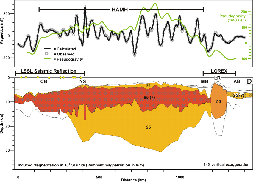
Figure 3: 2D model crossing Alpha Ridge extending from Canada Basin to the Amundsen Basin (location shown in Figs. 1 and 2). Synthetic profiles of bathymetry (Jacobsson et al., 2012) and magnetic anomalies (Gaina et al., 2011) were extracted from the published grids for the modeling. The top panel shows the observed and calculated magnetic anomalies and the pseudogravity anomaly (green line). The lower panel shows the geometry of magnetization parameters used in the magnetic modeling. The stippled pattern represents source bodies with both induced and remanent magnetization. Geometric constraints for the model are seismic reflection data (LSSL line, Mosher et al., 2009) and sonobuoy seismic refraction stations (Chian and Lebedeva-Ivanova, 2015; yellow dots) over Canada Basin, and the LOREX wide-angle seismic line (Forsyth and Mair, 1984) are shown on panel 6C. AB=Amundsen Basin; CB=Canada Basin; MB=Makarov Basin; NS=Nautilus Spur.
Comparison of the HAMH Magnetic Anomalies and Pseudogravity with Global Analogs
The magnetic anomalies and pseudogravity of four global LIPs (Ernst, 2014) are shown in Figure 4 to illustrate possible analogs for the HAMH. These examples have been chosen in part because of their geological variability, and because of adequate quality of regional magnetic coverage (necessary for calculating pseudogravity). Magnetic data for the Siberian Traps and Kerguelen Plateau are from the global EMAG2 compilation (Maus et al., 2009). The magnetic data for the Columbia Flood Basalts are from the North American NAMAG compilation (Bankey et al., 2002). Magnetic data for the North Atlantic Igneous Province are from the Atlantic-Arctic GAMMAA5 Verhoef et al. (1996) compilation. Pseudogravity anomalies were calculated using the same magnetization parameters as the HAMH.
Siberian Traps
The Siberian Traps are a large volcanic complex in central and northern Siberia consisting of early Triassic extrusive and intrusive basalts (Fig. 4A). The central extrusive flood basalts cover an area of ~7 x 10⁵ km2. Extensive dikes and sills intruded the regional Paleozoic successions and are exposed in a broad area around the central extrusive complex. To the west of the central extrusive complex, basalts have been sampled from several wells below the Mesozoic and Cenozoic strata of the West Siberian Basin and isolated volcanic centers correlate with the geometry of major extensional fault systems within the basin (Reichow et al., 2009). Structurally emplaced basalts also outcrop along the southern edge of the Taimyr Peninsula. The total area of the Siberian Trap volcanic province exceeds 5 x 10⁶ km2.
The magnetic anomalies over the central extrusive complex (Fig. 4A) have moderate amplitude high frequencies with a general chaotic character, similar to the HAMH. This pattern does not continue over the “intrusive rim” surrounding the central complex. Surprisingly, considering the large aerial extent and volume of the flood basalts, the pseudogravity anomaly high is localized only within the middle of the central complex. This suggests that the deep crustal portion of this complex has a limited extent. Over the West Siberian Basin, elongated magnetic highs correlate closely with the fault-bounded centers of the mapped volcanics. There pseudogravity shows large areas of positive amplitudes, suggesting that the aerial extent of the concealed volcanics within the basin may be much larger than the mapped exposures.
Columbia River Flood Basalts
The Neogene Columbia River Flood Basalt Province of Pacific Northwest United States covers an area of ~2.2 x10⁵ km2 (Fig. 4B). The province is broadly subdivided into the Oregon Plateau and the Columbia Basin. The southern edge of the province is coincident with the Snake River Plain which follows the Yellowstone mantle plume hotspot track. Although volcanism related to this system started initially in the southern Oregon Plateau, the Columbia Basin became the ultimate epicenter of the flood basalts with a maximum thickness of over 4 km (Reidel et al., 2013).
Similar in character to the Siberian Traps, the short-wavelength magnetic anomalies over the central extrusive complex have moderate amplitudes with a chaotic character. From the magnetic character alone, there is little difference between the anomalies within the Columbia Basin and Oregon Plateau; however, the calculated pseudogravity values are significantly different. The large positive pseudogravity high over the Oregon Plateau (suggesting a deeper crustal root) extends much further west of the Oregon Plateau and corresponds with a deep magnetic source. The Snake River Plain “hot-spot track” corresponds with a linear belt of short wavelength positive magnetic anomalies and a linear pseudogravity high. This is expected since the plume source would presumably have influenced the entire thickness of continental crust.
North Atlantic Igneous Province
The North Atlantic Igneous Province (NAIP) includes widespread early Tertiary continental flood basalts and seaward-dipping flows along the conjugate East Greenland and European margins (Fig. 4C). Excess volcanism is attributed to the influence of the Iceland Plume (e.g., Foulger, 1988; White, 1989; Clift et al., 1995), which maintained (approximately) a position coincident with the oceanic spreading ridge and formed the Greenland-Faeroes Ridge during the opening of the North East Atlantic. The aerial extent of the North Atlantic volcanic province (including Iceland and the Greenland-Faeroes Ridge) exceeds 1.3 x 10⁶ km2 (Coffin and Eldholm, 1994).
At the northern extent of the NAIP isolated high amplitude magnetic anomalies on the Northeast Greenland shelf, the Jan Mayen Microplate and the Vøring Marginal High off the Norwegian coast correspond with positive pseudogravity anomalies. High amplitude short-wavelength magnetic anomalies and a large positive pseudogravity anomaly associated with the Greenland-Faeroes Ridge implies a deep source. Despite extensive flood basalts on the Geikie Plateau, there are no high amplitude short-wavelength magnetic anomalies or positive pseudogravity anomaly in that region suggesting a thin or absent crustal root.
Kerguelen Plateau
The Kerguelen Plateau (Fig. 4D) in the southern Indian Ocean is defined primarily as a large regional bathymetric high. The plateau is considered a fragment rifted from the Gondwana supercontinent (125–100 Ma ago; Nicolaysen et al., 2000; Frey et al., 2000) that was later influenced by mantle plume volcanism (Bascou et al., 2008). Drill cores from OPD leg 183 recovered tholeitic basalts from the southern portion of the plateau and alkali basalts from the central plateau with age dates ranging from 109.5 to 114 Ma (Whitechurch et al., 1992). All samples had large geochemical and isotopic variations, suggesting continental crustal contamination. Garnet-biotite gneisses were sampled from Elan Bank confirming the presence of continental crust within the plateau. Upper Paleogene to Quaternary intrusive flood basalts and alkaline volcanic complexes are exposed onshore in the Kerguelan Islands (Nicolaysen et al., 2000) indicating active (plume related) volcanism. The areal extent of the Kerguelen Plateau is over 1.3 x 10⁶ km2 (Frey et al., 2000).
There is a large short wavelength positive magnetic anomaly pattern over most of the plateau, except northwest of the Kerguelen Islands where there is a magnetic low. The northwest-southeast magnetic lineations northeast of the plateau are seafloor spreading anomalies. The northeast-southwest magnetic lineations southwest of the plateau are possible gridding artifacts in the EMAG2 compilation. Very large high amplitude positive pseudogravity characterizes most of the plateau implying a deep crustal root. There is no positive pseudogravity northwest of the Kerguelan Islands which may mean the extent of the volcanics does not include all of the bathymetric high, or that they have strong reverse remanence. A large positive pseudogravity anomaly west of Elan Bank may represent a continuation of the volcanic province beyond the bathymetric expression.
Overview of LIP Comparisons
Comparison of the HAMH magnetic character and pseudogravity with global LIP analogs (Fig. 3) suggests the following conclusions: (1) LIPs are generally characterized by short-wavelength, high-amplitude magnetic anomalies with a “chaotic” pattern (diagnostic of upper crustal structures) and typically have associated pseudogravity highs (diagnostic of lower crustal structures); (2) continental flood basalt provinces do not generally exhibit a large positive pseudogravity anomaly over the entire LIP area (implying a more concentrated region of mid- and lower-crustal LIP related intrusions); (3) positive pseudogravity anomaly signatures (implying deep crustal extent) are associated with the roots (i.e. plume source region) of the LIP; and (4) of the analogs we have examined in detail, the Kerguelen Plateau bears the greatest similarity to the HAMH (similar magnetic and pseudogravity character and similar overall area/volume).
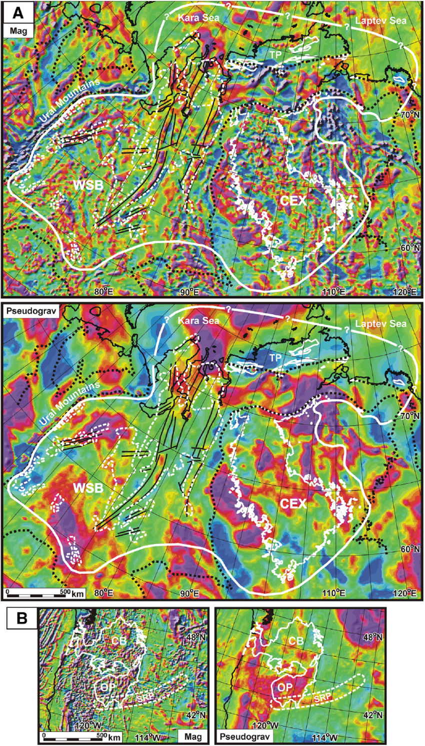
Figure 4: Global LIP analogs (magnetic anomaly and pseudogravity). 4A) Siberian Traps. The outline of the extrusive complex (CEX; thin white lines) and edges of the Mesozoic–Cenozoic basins (dotted black lines) are from Harrison et al. (2011). The aerial extent of the Siberian Traps (thick white lines), structural elements (thin black lines) within the West Siberian Basin (WSB), and distribution of buried volcanics (dashed white lines) within the WSB are adapted from Reichow et al. (2009). 4B) Columbia River Flood Basalts. The outline of the volcanic province (thick white line) is adapted from Reidel et al. (2013). A simplified outline of the Snake River Basin (SRB) (dotted white line) corresponds with the Yellowstone hot-spot track. The Columbia River Flood Basalt Province is subdivided into the southern Oregon Plateau (OP) and the northern Columbia Basin (CB).
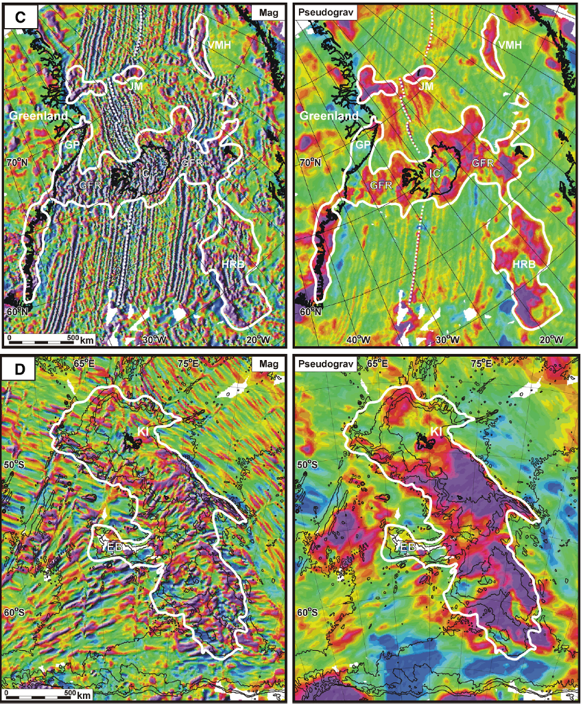
Figure 4: Global LIP analogs (magnetic anomaly and pseudogravity). 4C) North Atlantic Volcanic Province (NAIP). Magnetic data for the Icelandic region of the North Atlantic is from the Verhoef et al. (1996) GAMMAA5 compilation. The outline of the NAIP (thick white line) is based (primarily) on the calculated pseudogravity anomaly and includes the onshore exposures of Cenozoic volcanics from the geology map of Greenland (Escher and Pulvertaft, 1995) and estimates of the extent of volcanics in the offshore areas off East Greenland and the European margin (Coffin and Eldholm, 1994). The 1000 m bathymetric contours are shown (thin black lines). GFR= Greenland–Faeroes Ridge; GP = Geikie Plateau; IC= Iceland; JM=Jan Mayen micro-plate; VMH= Vøring Marginal High. 4D) Kerguelen Plateau. The outline of the Kerguelen Plateau (thick white line) is from Frey et al. (2000). The 1000 m bathymetric contours are shown (thin black lines). EB = Elan Bank; KI = Kerguelen Islands
Click to open/close ReferencesReferences
Bankey, V., et al., 2002. Digital data grids for themagnetic anomalymap of North America. US Geological Survey Open-file Report 2002-414 (http://pubs.usgs.gov/of/2002/ofr 02-414/).
Bascou, J., Delpech, G., Vauchez, A., Moine, B.N., Cottin, J.Y., and Barruol, G., 2008. An integrated study of microstructural, geochemical, and seismic properties of the lithospheric mantle above the Kerguelen plume (Indian Ocean). Geochemistry, Geophysics, Geosystems, v.9, no.4, 26pp, Q04036, doi:10.1029/2007GC001879 ISSN: 1525-2027.
Blakely, R.J., 1995. Potential Theory in Gravity and Magnetic Applications: Cambridge, UK, Cambridge University Press, 411 pp.
Chian, D., and Lebedeva-Ivanova, N., 2015. Atlas of sonobuoy velocity analyses in Canada Basin: Geological Survey of Canada, Open File 7661, 55 pp., doi:10.4095/295857.
Clift, P. D., Turner, J., and ODP LEG 152 Scientific Party, 1995. Dynamic support by the Iceland Plume and its effect on the subsidence of the northern Atlantic margins. Journal of the Geological Society, London, V.152, 1995, 935-941
Coffin, M.F., Eldholm, O., 1994. Large igneous provinces — crustal structure, dimensions, and external consequences. Rev. Geophys. 32 (1), 1–36.
Ernst, R.E., 2014. Large Igneous Provinces. Cambridge University Press, 653 p.
Escher, J.C., and Pulvertaft, T.C.R., 1995. Geological map of Greenland, 1:250000. Copenhagen: Geological Survey of Greenland.
Forsyth, D. A., and Mair, J. A., 1984. Crustal Structure of the Lomonosov Ridge and the Fram and Makarov basins near the north pole. Journal of Geophysical Research, v. 89, B1, 473-481.
Foulger, G. R., 1988. Hengill Triple Junction, SW Iceland, Part 1: Tectonic structure and the spatial and temporal distribution of local earthquakes. Journal of Geophysical Research, v. 93-Bll, 13, 493-13,506.
Forsyth, D.A., Morel-l'Huissier, P., Asudeh, I., Green, A.G., 1986b. Alpha Ridge and Iceland — products of the same plume? J. Geodyn. 6, 197–214.
Frey, F.A., Coffin, M.F., Wallace, P.J., Weis, D., Zhao, X., Wise Jr., S.W., Wahnert, V., Teagle, D.A.H., Saccocia, P.J., Reusch, D.N., Pringle, M.S., Nicolaysen, K.E., Neal, C.R., Muler, R.D., Moore, C.L., Mahoney, J.J., Keszthelyi, L., Inokuchi, H., Duncan, R.A., Delius, H., Damuth, J.E., Damasceno, D., Coxall, H.K., Borre, M.K., Boehm, F., Barling J., Arndt N.T., and Antretter ,M., 2000. Origin and evolution of a submarine large igneous province: the Kerguelen Plateau and Broken Ridge, southern Indian Ocean. Earth and Planetary Science Letters, v. 176, 73-89.
Funck, T., Jackson, H.R., Shimeld, J., 2011. The crustal structure of the Alpha Ridge at the transition to the Canadian Polar Margin — results from a seismic refraction experiment. J. Geophys. Res. B Solid Earth 116 (B12101). http://dx.doi.org/10.1029/ 2011JB008411 (26 pp.).
Gaina, C.,Werner, S., Saltus, R., Maus, S., the CAMP-GM Group, 2011. Circum-Arctic Mapping Project — new magnetic and gravity anomaly maps of the Arctic. In: Spencer, A.M., et al. (Eds.), Arctic Petroleum Geology. Geological Society of London Memoir 35, pp. 39–48.
Harrison, J.C., St-Onge, M.R., Petrov, O.V., Strelnikov, S.I., Lopatin, B.G.,Wilson, F.H., Tella, S., Paul, D., Lynds, T., Shokalsky, S.P., Hults, C.K., Bergman, S., Jepsen, H.F., Solli, A., 2011. Geological map of the Arctic/Carte géologique de l'Arctique. Geological Survey of Canada. “A” Series Map 2159A, 9 Sheets; 1 DVD http://dx.doi.org/10.4095/287868.
Jakobsson,M.,Mayer, L., Coakley, B., Dowdswell, J., Forbes, S., et al., 2012. The International Bathymetric Chart of the Arctic Ocean (IBCAO) version 3.0. Geophys. Res. Lett. 39, L12609. http://dx.doi.org/10.1029/2012GRL052219 (6 pp.).
Lebedeva-Ivanova, N.N., Zamansky, Y.Y., Langinen, A.E., Sorokin, M.Y., 2006. Seismic profiling across the Mendeleev Ridge at 82°N: evidence of continental crust. Geophys. J. Int. 165, 527–544.
Maher, H.D., Jr., 2001. Manifestations of the Cretaceous High Arctic Large Igneous Province in Svalbard: The Journal of Geology, v. 109, no. 1, 91-104.
Maus, S., et al., 2009. EMAG2: a 2-arc min resolution earth magnetic anomaly grid complied from satellite, airborne, and marine magnetic measurements. Geochem. Geophys. Geosyst. 10 (8). http://dx.doi.org/10.1029/2009GC002471.
Mosher, D.C., Shimeld, J.D. and Hutchinson, D.R. 2009: 2009 Canada Basin seismic reflection and refraction survey, western Arctic Ocean: CCGS Louis S. St-Laurent expedition report, Geological Survey of Canada Open File 6343, 266 pp.
Nicolaysen, K., Frey, F. A., Hodges, K. V., Weis D., and Giret, A., 2000. 40Ar/39Ar geochronology of flood basalts from the Kerguelen Archipelago, southern Indian Ocean: Implications for Cenozoic eruption rates of the Kerguelen plume, Earth Planet. Sci. Lett., 174, 313–328. doi: 10.1016/S0012-821X(99) 00271-X.
Oakey, G.N, and Saltus, R.W., 2016, Geophysical analysis of the Alpha-Mendeleev ridge complex – Characterization of the High Arctic Large Igneous Province: Tectonophysics v. 691, p. 65-84.
Reichow, M.K., Pringle, M.S., Al'Mukhamedo, A.I., Allen, M.B., Andreichev, V.L., Buslov, M.M., Davies, C.E., Fedoseev, G.S., Fitton, J.G., Inger, S., Medvedev, A.Y., Mitchell, C., Puchkov, V.N., Safonov, I.Y., Scott, R.A., Saunders, A.D., 2009. The timing and extent of the eruption of the Siberian Traps large igneous province: implications for the end-Permian environmental crisis. Earth Planet. Sci. Lett. 277, 9–20 (10.1016/j.epsl.2008.09.30).
Reidel, S.P., Camp, V.E., Tolan, T.L., Kauffman, J.D., Garwood, D.L., 2013. Tectonic evolution of the Columbia River flood basalt province. In: Reidel, S.P., Camp, V.E., Ross, M.E., Wolff, J.A., Martin, B.S., Tolan, T.L.,Wells, R.E. (Eds.), The Columbia River Flood Basalt Province: Geological Society of America Special Paper 497, pp. 293–324 http://dx.doi.org/10.1130/2013.2497(12).
Saltus, R.W., Miller, E.L., Gaina, C., Brown, P.J., 2011. Regional magnetic domains of the Circum-Arctic — a framework for geodynamic interpretation. In: Spencer, A.M., et al. (Eds.), Arctic Petroleum Geology. Geological Society of London Memoir 35, pp. 49–60.
Treshnikov, A. F., Balakshin, L.L., Belov, N.A., Demenitskaya, R.M., Dibner, V.D., Karasik, A.M., Shpeiker, A.O., and Shurgayeva, N.D., 1967. A geographic nomenclature for the chief topographic features, the bottom of the Arctic Basin, Problems of the Arctic and Antarctic, p. 27.
Verhoef, J., Roest,W., Macnab, R., Arkani-Hamed, J., Members of the Project Team(Kovacs, S., Levesque, S., Morris, P., Oakey, G., Srivastava, S., Stark, A., Usow, K., and Vardy, D.), 1996. A compilation of magnetic observations from the Arctic and North Atlantic Oceans and adjacent land areas (CD-ROM data release). Geological Survey of Canada, Open File 3125a.
White, R. S. 1989. Initiation of the Iceland plume and opening of the North Atlantic. In: Tankard, A. J. and Balkwill, H. R. (eds) Extensional Tectonics and Stratigraphy of the North Atlantic Margins. American Association of Petroleum Geologists, Memoir, 46, 149–154.
Whitechurch, H., Montigny, R., Sevigny, J., Storey, M., and Salters, V.,1992. K-Ar and 40Ar-39Ar ages of central Kerguelen Plateau basalts, in: Proc. Ocean Drill. Prog., Scientific Results 120, W.S. Wise and R. Schlich, et al., Ocean Drill. Prog., College Station, TX, 1992, 71-77.