June 2016 LIP of the Mont
Lateral magma flow in mafic sill-complexes
Craig Magee1, James D Muirhead2, Alex Karvelas3, Simon P Holford4, Christopher A-L Jackson1, Ian D. Bastow1, Nick Schofield5, Carl TE Stevenson6, Charlotte McLean7, William McCarthy8, Olga Shtukert3
1Basins Research Group, Department of Earth Science and Engineering, Imperial College, London, SW7 2BP, UK
2Department of Geological Sciences, University of Idaho, Moscow, Idaho 83844, USA
3Schlumberger Multiclient, Schlumberger House, Buckingham Gate, West Sussex, RH6 0NZ, UK
4Australian School of Petroleum, University of Adelaide, Adelaide, SA 5005, Australia
5Geology & Petroleum Geology, School of Geosciences, University of Aberdeen, Aberdeen, AB24 3UE, UK
6School of Geography, Earth & Environmental Sciences, University of Birmingham, Birmingham, B15 2TT, UK
7School of Geographical and Earth Sciences, University of Glasgow, Glasgow, G12 8QQ, UK
8Department of Earth Sciences, University of St Andrews, St Andrews, KY16 9AL, UK
Email: c.magee@imperial.ac.uk
Based on: Magee C, Muirhead JD, Karvelas A, Jackson CAL, Bastow I, Holford SP, Schofield N, Stevenson CTE, McLean C, McCarthy W, Shtukert O, 2016, Lateral magma flow in sill-complexes, Geosphere, 12, 1-33, doi:10.1130/GES01256.1. http://geosphere.gsapubs.org/content/12/3/809.short
Introduction
Large Igneous Provinces (LIPs) (Ernst, 2014) preserve a record of major magma-tectonic events that have occurred throughout geological time. Constraining plumbing system structure is critical to unravelling the emplacement and melt history of these LIPs, which in turn provides insight into ancient plate configurations and tectonic processes (e.g., Ernst et al., 2005; Ernst et al., 2013). In particular, four key questions concerning plumbing system structure need to be addressed (Ernst et al., 2005):
1) Where and how does magma enter the crust?
2) How is magma distributed through the crust?
3) What is the melt volume of the plumbing system?
4) Over how long was the plumbing system emplaced (i.e. a proxy for melt production rate)?
To date, the vast majority of studies focus on the importance of mafic dike swarms in facilitating extensive magma transport within LIPs (e.g., Ernst et al., 2001; Ernst, 2014), whereas the role of sills is often overlooked. However, recent field- and seismic reflection-based research shows that magma transport in many LIP systems may occur through interconnected networks of mafic sills and inclined sheets (i.e. a sill-complex) (Thomson and Hutton, 2004; Cartwright and Hansen, 2006; Magee et al., 2014; Muirhead et al., 2014; Schofield et al., 2015; Magee et al., 2016). Mapping of flow indicators and magma geochemistry reveal that sill-complexes can enable magma transport over distances of up to 12 km vertically and 4100 km laterally (Cartwright and Hansen, 2006; Leat, 2008). It is the aim of this contribution, which is based on Magee et al., (2016), to bring together current research on sill-complex emplacement, by synthesizing new and published data from several case studies, providing a basis for future research focusing on sill-complexes within LIPs.
Summary of the use of seismic reflection data to understanding plumbing systems
High-quality, marine seismic reflection data, have arguably revolutionized our understanding of sill-complex emplacement because it allows sub-surface intrusion networks to be imaged in 3D at resolutions on the order of tens of meters (e.g., Fig. 1) (e.g., Smallwood and Maresh, 2002; Thomson and Hutton, 2004; Cartwright and Hansen, 2006; Magee et al., 2014; Magee et al., 2016). Before discussing specific case study examples, it is worthwhile to briefly consider seismic interpretation methodologies for recognizing and characterizing igneous intrusions. Sills are relatively well imaged in seismic data because igneous rocks commonly have greater densities and seismic velocities compared to the surrounding sedimentary strata. These physical differences at the intrusion-host rock contacts result in a high acoustic impedance contrast (Smallwood and Maresh, 2002), which reflects more seismic energy back to the surface than low impedance boundaries typically occurring between sedimentary rock sequence (Brown, 2004). In seismic data, igneous bodies are therefore commonly expressed as high-amplitude reflections (e.g., Fig. 1). One limitation of seismic data, however, is that sub-vertical dikes are rarely imaged because little acoustic energy reflects back to the surface off the sub-vertical wall of a dike (Thomson, 2007).
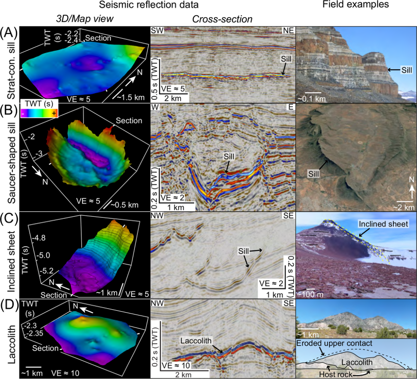
Figure 1: Seismic and field examples of: (A) strata-concordant (strat-con.) sills observed offshore southern Australia (see Jackson et al., 2013) and in the Theron Mountains, Antarctica (field photo courtesy of Donny Hutton); (B) saucer-shaped sills observed in seismic data from the Exmouth Sub-basin, NW Australia (modified from Magee et al., 2013e) and the Golden Valley Sill in South Africa (Google Earth image); (C) inclined sheets in the Rockall Basin (modified from Magee et al., 2014) and Antarctica; and (D) laccoliths observed offshore southern Australia (modified from Jackson et al., 2013) and in the Henry Mountains, Utah, USA. Vertical axes in seismic images are in two-way travel time (TWT) and are vertically exaggerated (VE).
An important technique in seismic interpretation of sill-complexes is the mapping of seismically resolvable magma flow indicators (e.g., intrusive steps, bridge structures, and magma fingers), which according to synthetic seismic forward modelling are manifest as minor vertical offsets in sill reflections (Magee et al., 2015). Field studies indicate that these structures form because sheet intrusions typically do not initially intrude as continuous bodies of magma but rather propagate as thin, laterally restricted magma segments that are vertically and/or laterally offset from each other (Fig. 2) (e.g., Rickwood, 1990; Hutton, 2009; Schofield et al., 2012a). With sustained magma input, these segments inflate and coalesce to form a continuous sheet intrusion, but the vertical offsets are preserved (Fig. 2) (Hutton, 2009; Schofield et al., 2012a). The long axes of these structures, which correlate to the primary magma flow axis (Fig. 2) (e.g., Schofield et al., 2012a), can be mapped to discern magma flow patterns and input zones (Thomson and Hutton, 2004; Magee et al., 2014).
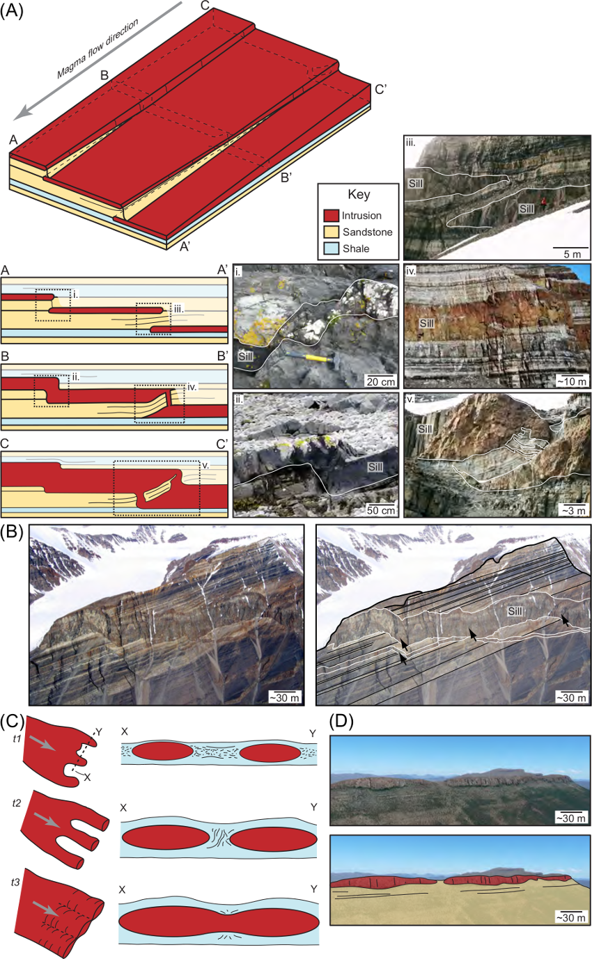
Figure 2: (A) Magma flow indicators (i.e. intrusive steps and bridge structures) produced by brittle fracture processes. Field photos i. and ii. are of intrusive steps observed in inclined sheets and sills on Ardnamurchan, NW Scotland. Field photos iii., iv., and v. from the Theron Mountains, Antarctica, document the growth of an intact sedimentary bridge between two magma segments (iii) into a broken bridge (iv) and a bridge xenolith (v) with increasing distance from the magma source (photos courtesy of Donny Hutton). (B) Magma finger formation (modified from Schofield et al., 2012a). (C) An uninterpreted and interpreted field photo of magma fingers in the Golden Valley Sill, South Africa.
Geologic examples of sill-complexes from field and seismic-based observations
Karoo-Ferrar LIP
Magmatism in the Karoo-Ferrar LIP began ~183 Ma (Encarnación et al., 1996), in response to plume and rift-related magmatism (Elliot and Fleming, 2000; Leat, 2008; Hasie et al. 2014; Hole, 2015). Initial activity involved rapid emplacement (~1 Myr) of significant magma volumes (>1 × 10⁶ km3) in the geographically separated sill-complexes of Karoo and Ferrar (Heimann et al., 1994; Elliot and Fleming, 2000; Leat, 2008; Svensen et al., 2012). The Ferrar sill-complex outcrops in Antarctica, SE Australia, and New Zealand, suggesting that the province extends for over 4100 km from the proposed site of a plume head source (Fig. 3B and C) (Mortimer et al. 1995; Elliot et al., 1999; Elliot and Fleming, 2000; Leat, 2008). Ferrar intrusive rocks of Antarctica occur almost exclusively within the 2.5 km thick Beacon Supergroup (e.g., Fig. 3C). The abundance of dikes is limited, and magma transport primarily occurred and was linked to the surface through interconnected sill-complexes (e.g., Figs 3A and B) ( Leat, 2008; Airoldi et al., 2012; Muirhead et al., 2012, 2014). The role of Ferrar sills in facilitating ~4100 km of lateral magma flow across the East Antarctic Margin is supported by: (1) observed sill-sill feeding relationships (Muirhead et al., 2012; Muirhead et al., 2014); (2) decreasing Mg# and MgO contents consistent with fractional crystallization during lateral magma flow as far as 4100 km from the Weddell Sea region (Elliot et al., 1999; Elliot and Fleming, 2000; Leat, 2008); and (3) the consistent orientation of broken bridge structure long axes and magnetic lineations within sills and interconnected sheets across Antarctica (e.g., in the Theron Mountains, Antarctica) (Dragoni et al., 1997; Hutton, 2009; Airoldi et al., 2012).
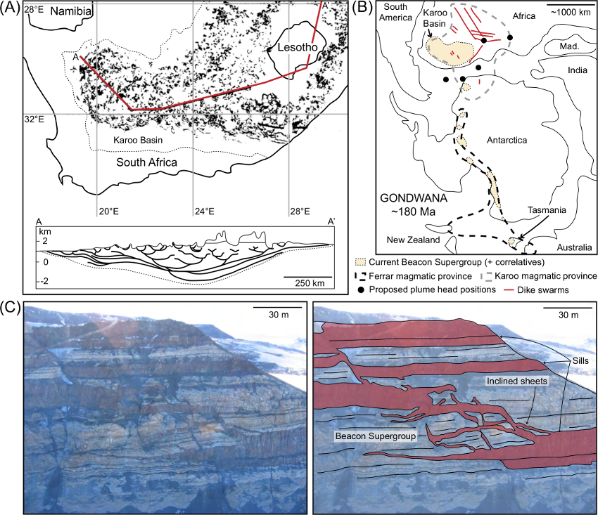
Figure 3: (A) Distribution of sills (black) within the Karoo Basin (dashed outline) and a schematic cross-section (modified from Svensen et al., 2012). (B) Paleogeographic reconstruction (~180 Ma) highlighting the current extent of the Karoo-Ferrar large igneous province and associated basin exposures (based on Mortimer et al., 1995; Leat, 2008; Hastie et al., 2014). Mad. = Madagascar. (C) Field photo and interpreted photo of interconnected Ferrar sills and inclined sheets intruded into the Beacon Supergroup in Antarctica (courtesy of James White).
Sill-complexes in the North Atlantic Igneous Province
The North Atlantic Igneous Province formed ~62–53 Ma in response to the break-up of the North Atlantic and the impingement of a mantle plume at the base of the lithosphere (Saunders et al., 1997; Storey et al., 2007). Voluminous sill-complexes, dike swarms, volcanic centers, and extrusive igneous rocks, primarily of basaltic composition, were emplaced during these phases (~6.6 × 10⁶ km2 in total) and are located along two volcanic rifted margins; the conjugate East Greenland–NW European and the West Greenland–Baffin Bay margins (Storey et al., 2007).
Irish Rockall Basin, North Atlantic
Magee et al. (2014) analyzed a sill-complex, located along the north-eastern margin of the Irish Rockall Basin, which consisted of 82 seismically resolved intrusions (Fig. 4). Individual intrusions predominantly displayed saucer-shaped and inclined sheet morphologies, which range in diameter from 0.3–7.1 km and transgress up to 1.79 km of strata (Magee et al., 2014). The sill-complex cross-cuts a ~2 km thick stratigraphic sequence of Cretaceous marine shale and Paleogene volcaniclastic sandstone (Fig. 4), and extends across an area of >748 km2 (Magee et al., 2014). The main inclined portions of the intrusions primarily dip to the NW and the sills appear to be interconnected; i.e. inclined sheets and sill limbs apparently feed stratigraphically saucer-shaped sills (Fig. 4) (Magee et al., 2014). Connectivity between individual sills is supported by mapping of flow indicators, which commonly radiate outwards from inferred sill-sill feeder zones (Magee et al., 2014). Observations related to sill connectivity are consistent with a regional, south-easterly directed, lateral magma flow regime, perhaps indicative of a melt source associated with the Hebridean Terrace Igneous Complex located <10 km to the NW (Magee et al., 2014).
In addition to delimiting plumbing systems and flow patterns, it is also important to constrain the timeframe of magmatic activity. Above the sill-complex mapped by Magee et al. (2014), a series of dome-shaped folds are developed within the Upper Cretaceous to top Lower Eocene strata (Fig. 4). The outline of these folds corresponds to the lateral termination of underlying sills and, particularly along the Top Paleocene horizon, seismic reflections can be observed to onlap onto the folds (Fig. 4) (Magee et al., 2014). These seismic-stratigraphic relationships imply that fold growth was generated by and accommodated sill emplacement, resulting in the formation of bathymetric highs that were onlapped by syn-kinematic sediment (Trude et al., 2003; Hansen and Cartwright, 2006; Jackson et al., 2013; Magee et al., 2013e; Magee et al., 2014). Importantly, onlap relationships are observed throughout the folded succession, between the top Cretaceous and top Lower Eocene boundaries (Fig. 4), suggesting that sill emplacement and fold growth occurred incrementally over 15 Myr between ~65–54 Ma (Magee et al., 2014).
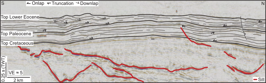
Figure 4: Seismic section of forced folds and the underlying sill-complex imaged along the eastern margin of the Irish Rockall Basin.
Faroe-Shetland Basin, North Atlantic
An extensive sill-complex covering >22,500 km2 and emplaced primarily within Upper Cretaceous shale is imaged in seismic reflection data from the Faroe-Shetland Basin (Fig. 5A and B) (Passey and Hitchen, 2011; Schofield et al., 2015). Radiometric dating of sills penetrated by boreholes and relative ages of sills determined from seismic-stratigraphic relationships suggests that intrusion occurred between ~61–52 Ma (Passey and Hitchen, 2011; Schofield et al., 2015). Whilst >300 seismically resolved sills have been mapped in the basin (Fig. 5A), borehole data suggest that a significant proportion (up to ~80%) of intrusions have thicknesses below the limit of detectability of the seismic data and are not resolved (Schofield et al., 2015). The sills that are resolved display a wide variety of morphologies (e.g., saucer-shaped sills and inclined sheets) and have diameters up to tens of kilometers (e.g., Fig. 5) (Schofield et al., 2015). Individual intrusions may transgress up to 2 km of the sedimentary succession and appear to connect to overlying sills, inclined sheets, and lava flows (e.g., Fig. 5) (Schofield et al., 2012b; Schofield et al., 2015). Reconstruction of flow patterns within the Faroe-Shetland Basin sill-complex implies that magma was fed into the basin via basement-involved faults, from which sills propagated laterally for up to ~25 km into the hanging wall (Fig. 5) (Schofield et al., 2015).
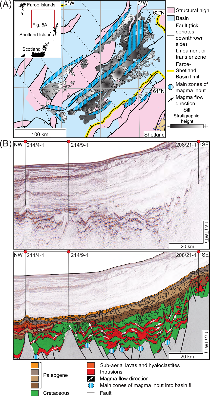
Figure 5: (A) Regional geology of the Faroe-Shetland Basin, including seismically mapped sills and magma flow directions. Magma flow patterns were used to infer magma input zones into the basin (modified from Schofield et al., 2015). (B) Representative seismic line (uninterpreted and interpreted) highlighting sill-complex structure and association with faults (Schofield et al., 2015).
Møre and Vøring basins, North Atlantic
Sill-complexes developed along the Norwegian margin (Fig. 6A) represent a continuation of the Late Cretaceous-to-Paleogene magmatic activity that generated networks of intrusions within the Rockall and Faroe-Shetland basins to the south-west (Skogseid et al., 1992; Planke et al., 2005; Cartwright and Hansen, 2006; Hansen, 2006). Sills were predominantly emplaced into Late Cretaceous and Early Paleocene shale, although some sills intruded older sedimentary strata and crystalline basement at ~55 Ma (Svensen et al., 2004; Planke et al., 2005; Hansen, 2006). Overall, the interconnected sill-complexes extend across >80,000 km2 of the basin and, in places, transgresses up to 12 km of sedimentary strata and crystalline basement (e.g., Fig. 6) (Svensen et al., 2004; Planke et al., 2005; Cartwright and Hansen, 2006). Observations from the Møre and Vøring basins are consistent with those gathered from the Rockall and Faroe-Shetland basins; i.e. interconnected sill-complexes within sedimentary basins are laterally extensive and provide an efficient mechanism for magma ascent (e.g., Fig. 6B) (Cartwright and Hansen, 2006).
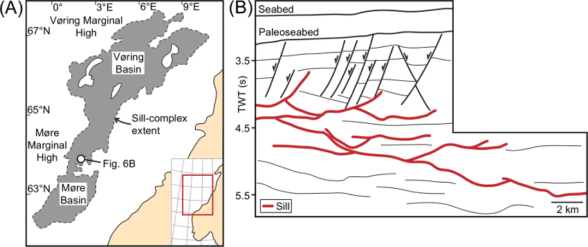
Figure 6: (A) Sill-complex distribution (grey) within the Møre and Vøring basins offshore Norway (modified from Svensen et al., 2004). (B) Line drawing of a seismic line from Cartwright and Hansen (2006).
Northern Yilgarn Craton, Western Australia
The Youanmi Terrane in the Yilgarn Craton of Western Australia (Figs 7A and B) contains substantial greenstone belts separated by granite and granitic gneiss, which formed principally between ~3.05 and ~2.62 Ga (Cassidy and Australia, 2006). The interpretation of three deep seismic reflection profiles across the Youanmi Terrane has led to the identification of an interconnected network of highly reflective, generally saucer-shaped sills that extend for several hundreds of kilometers (e.g., Figs 7C and D) (Ivanic et al., 2013). Some sills appear to have been intruded along shear zones, whilst others cross-cut and truncate reflections associated with pre-existing shear zones and listric faults (Figs 7C and D) (Ivanic et al., 2013). These sills have been attributed to the ~1070 Ma Warakurna LIP (Ivanic et al., 2013) (Wingate et al., 2004). The sill that extends from Common Depth Point (CDP) 6500 to CDP 11000 on seismic profile 10GA-YU2 (Fig. 7D) is thought to be the Mount Homes Gabbro Sill, which crops out near the town of Sandstone and has a crystallization age of 1070 ± 18 Ma based on SHRIMP U-Pb dating of baddeleyite (Wingate et al., 2008). Aeromagnetic data suggests that the strike length of the sill exceeds 400 km (Wingate et al., 2008). The interconnected network of saucer-shaped sills interpreted from the Yilgarn Craton seismic data share many characteristics with those documented in the other case studies presented in this contribution. Importantly, the Yilgarn Craton data suggest that interconnected sill-complexes facilitating long-distance lateral magma transport can develop within crystalline continental crust.
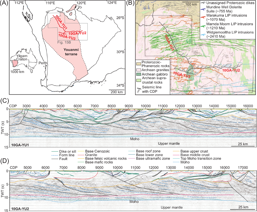
Figure 7: (A) Geology of the Yilgarn Craton showing terrane boundaries and locations of Youanmi seismic lines (modified from Wyche et al., 2013). (B) Interpreted geological map of the northern Yilgarn Craton showing suites of Proterozoic intrusions in the region of the Youanmi seismic lines (modified from Ivanic et al., 2013). (C) Interpreted deep seismic reflection profile 10GA-YU1. Note abundant high amplitude reflection packages interpreted to be saucer-shaped sills in the shallow parts (<5 s TWT) of the profile (modified from Ivanic et al., 2013). (D) Interpreted migrated deep seismic reflection profile 10GA-YU2 (modified from Ivanic et al., 2013).
Discussion
The seismic reflection data and field observations presented here demonstrate that sill-complexes can form integral components of LIP plumbing systems. In particular, it is clear that sill-complexes provide efficient magma flow pathways, transporting melt from source to surface over great vertical (10’s km) and lateral distances (>100’s km) (e.g., Cartwright and Hansen, 2006; Leat, 2008; Schofield et al., 2015; Magee et al., 2016). Here, we discuss how sill-complexes may fit into the answer of the four key questions concerning plumbing system structure that were highlighted at the start.
1) Where and how does magma enter the crust?
Whilst the exact source of numerous sill-complexes remains poorly constrained, commonly due to a paucity of seismic and/or borehole data in relevant areas, mapping of magma flow patterns has suggested that some sill-complexes may: (1) originate from underlying melt zones (high-velocity bodies in seismic data) via dikes, fault-hosted inclined sheets, or transgressive sills (e.g., Figs 5A and B) (e.g., Cartwright and Hansen, 2006; Galerne et al., 2011; Rohrman, 2013; Schofield et al., 2015); (2) be fed by laterally propagating dike swarms that emanate from volcanic centers or mantle plume heads (e.g., Hyndman and Alt, 1987; Ernst et al., 1995); (3) propagate directly away from volcanic centers (Magee et al., 2014); or (4) be sourced directly from a plume head, with lateral flow promoted by emplacement into an area of topographic uplift above the plume head and the generation of a hydraulic gradient sufficient enough to allow sills (<10 m thick) to flow laterally for 1000’s of kilometers without freezing (Fialko and Rubin, 1999; Aspler et al., 2002; Leat, 2008).
2) How is magma distributed through the crust?
Field- and seismic-based observations suggest that interconnected sill-complexes can transgress up to 12 km of strata and transport magma across lateral distances of up to 4100 km regardless of the rock types intruded (e.g., Figs 3-7) (e.g., Aspler et al., 2002; Cartwright and Hansen, 2006; Leat, 2008; Svensen et al., 2012; Magee et al., 2014; Muirhead et al., 2014; Schofield et al., 2015; Magee et al., 2016). An important constraint on the areal extent of sill-complexes appears to be the presence of fault arrays, or other pre-existing structures, which can limit lateral magma propagation by providing suitable magma ascent pathways to the Earth’s surface or to shallower stratigraphic levels (e.g., Fig. 5B) (Magee et al., 2016). Sill-complexes emplaced within relatively unstructured rocks (e.g., the Karoo Basin), however, cover areas that are orders of magnitude larger than those intruded into intensely faulted rocks; e.g., the Karoo sill-complex covers ~3 × 10⁶ km2 (Fig. 3A), whereas sill-complexes across the Møre and Vøring rift basins only cover ~8 × 10⁴ km2 (Fig. 6A) (cf. Planke et al., 2005; Leat, 2008; Svensen et al., 2012; Magee et al., 2014; Schofield et al., 2015).
From the case studies presented above it is clear that inclined sheets transfer magma from deeper sills to shallower stratigraphic levels and are integral to facilitating magma ascent in sill-complexes (Thomson and Hutton, 2004; Cartwright and Hansen, 2006; Holford et al., 2012; Muirhead et al., 2012; Magee et al., 2013a; Magee et al., 2014). Several mechanisms have been recognized that may promote the development of inclined sheets: (1) numerical modelling has demonstrated that towards the lateral tips of a sill, during intrusion and/or inflation, σ1 in the overburden is radially inclined inwards and can promote tensile failure and inclined sheet transgression (e.g., Gudmundsson, 2002; Malthe-Sørenssen et al., 2004; Barnett and Gudmundsson, 2014); (2) some sill-fed inclined sheet swarms are emplaced as mixed-mode fractures, whereby dilation normal to the inclined sheet plane and sub-vertical opening of the sill segments results in mixed-mode I-II fracturing (e.g., the Ferrar sill-complex, Antarctica, Muirhead et al., 2012, 2014); (3) emplacement of magma along reverse faults that nucleated during the growth of flat-topped forced folds (Thomson and Schofield, 2008; Bunger and Cruden, 2011); (4) intrusion along pre-existing faults (e.g., Fig. 5B) (Bedard et al., 2012; Magee et al., 2013a; McClay et al., 2013); or (5) the upward deflection, along a curved trajectory, of a propagating fracture beyond the lateral tip of a sill in response to the asymmetrical emplacement of magma above the initial level of the extension fracture (Hansen, 2015). Overall, magma ascent along inclined sheets in sill-complexes is likely facilitated by multiple processes and resolving the key controls on transgression is therefore challenging (Magee et al., 2016).
3) What is the melt volume of the plumbing system?
An important consideration when examining sill-complexes using seismic reflection data concerns the role of dikes, which are rarely imaged, in facilitating magma transport between individual sills, inclined sheets, and the surface. Whilst field observations indicate that dikes may be volumetrically minor components of sill-complexes (e.g., Fig. 3) (e.g., the Karoo-Ferrar LIP; Leat, 2008; Hastie et al., 2014; Muirhead et al., 2014), it is likely that the volume of dikes seismically imaged in sill-complexes is underestimated. Furthermore, the majority of sills within a sill-complex likely have thicknesses below the limit of detectability in seismic data, implying that the volume of sills may too be underestimated (Schofield et al., 2015). Whilst seismic reflection data can thus provide unprecedented images of plumbing system structure in three-dimensions, extracting volumetric information remains challenging (Magee et al., 2016).
4) Over how long was the plumbing system emplaced (i.e. a proxy for melt production rate)?
Sill-complexes represent tortuous, magma ascent pathways compared to swarms of dikes. It may therefore be expected that magma migration, from melt source to the Earth’s surface, will take longer if facilitated by sill, as opposed to dike, emplacement (Magee et al., 2016). The duration of sill-complex development may thus prolong magma residence times, affecting geochemical and petrological processes. For sill-complexes where absolute age data is available or relative dating techniques can be employed, studies suggest that magma injection occurs rapidly over a few million years (Skogseid et al., 1992; Archer et al., 2005; Planke et al., 2005; Cartwright and Hansen, 2006; Hansen and Cartwright, 2006; Hansen, 2006; Svensen et al., 2012). For example, radiometric dating suggests that the Karoo sill-complex were emplaced over 0.47 Myr at a rate of 0.78 km3/yr (Svensen et al., 2012). However, Magee et al. (2014) show multiple onlap relationships in forced folded successions above a sill-complex in the Rockall Basin, suggesting that fold growth, and thereby sill emplacement, occurred incrementally over ~15 Myr through the periodic injection of small magma batches (Fig. 4). Evidence for the prolonged development of a sill-complex in the Rockall Basin therefore implies that seismic-stratigraphic or radiometric dates obtained from only one or several intrusions in a sill-complex, which most previous studies rely upon, cannot reliably be applied to the entire magmatic network (Magee et al., 2014).
Numerous studies have documented that individual sills, as well as entire intrusion networks, may develop through the emplacement of distinct magma pulses (e.g., Glazner et al., 2004; Michel et al., 2008; Annen et al., 2015; Broderick et al., 2015). If some sill-complexes are indeed emplaced incrementally but over timeframes in which magma solidification should theoretically occur, how then does magma rheology vary and how do magma migration pathways remain operational within these systems? Consider a scenario whereby new distinct magma pulses may intrude along the contact, which likely represent a strong mechanical discontinuity, between fully or partially solidified intrusions and the host rock (i.e. under- or over-accretion; Fig. 8A) (see Annen et al., 2015 and references therein). This stacking and amalgamation of sills through repeated magma injection along sill-host rock contacts can influence its thermal and chemical evolution (see Annen et al., 2015 and references therein). If the duration between distinct pulses is too long, allowing the pre-existing intrusion to cool and potentially solidify, any new batch of magma is effectively intruded into a relatively low-temperature environment (Annen, 2011). The accretion of new magma above or below a pre-existing sill or stack of sills, within a relatively low-temperature environment will therefore simply serve to thicken the igneous body, potentially forming layered intrusions, without significant lateral propagation (e.g., Menand, 2008; Annen, 2011). If, however, the duration between the injection of distinct magma pulses is short and/or there is sufficient latent heat of crystallization, the maintenance of locally elevated temperatures may allow later magma pulses to remain hotter for longer, facilitating intrusion further up into the stratigraphic sequence (Fig. 8A) (e.g., Glazner et al., 2004; Annen, 2011; Annen et al., 2015; Magee et al., 2016).
An alternative explanation concerns the development and prolonged longevity of discrete magma flow pathways within individual intrusions (Fig. 8B). Numerous studies have shown that sills commonly form through the coalescence of magma segments or fingers and, on a larger scale, magma lobes (e.g., Fig. 2) (e.g., Pollard et al., 1975; Thomson and Hutton, 2004; Schofield et al., 2010; Schofield et al., 2012b; Schofield et al., 2012a). The channelization of magma into one or several of these zones can increase the segment thickness, allowing magma flow to be sustained whilst neighboring portions of the intrusion crystallize (Fig. 8B) (Holness and Humphreys, 2003). If these channelized segments remain partially molten, through the continued injection of small magma batches and/or insulation by adjacent lobes, subsequent magma pulses may preferentially reactivate the channels (Fig. 8B) (Currier and Marsh, 2015; Magee et al., 2016). Flow of magma through thin channels, which then bud off to form larger sills, is supported by mapped magma flow patterns which suggest that sills are intruded from a point-like source (Thomson and Hutton, 2004; Magee et al., 2013a; Magee et al., 2014; Schofield et al., 2015).
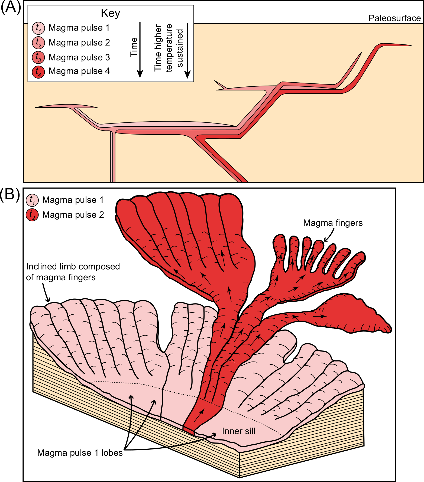
Figure 8: (A) Schematic diagram demonstrating how the emplacement of one magma pulse may facilitate the intrusion of later pulses further up into the sedimentary sequence if accretion allows sills to remain hotter for longer (Annen et al., 2015). (B) Sketch depicting how discrete magma segments and/or lobes may preferentially remain open as magma channels (magma pulse 2), feeding stratigraphically higher intrusions, when adjacent portions of the sill have crystallized (magma pulse 1).
Conclusion
Sill-complexes are integral components of LIP plumbing systems. Mapping sill-complex structure is critical in defining the source area, volume, and production rate of melt within LIPs, as well as constraining how magma moves through the crust and where it is erupted. Seismic reflection data provides a powerful toolset for interpreting entire sill-complexes and mapping regional magma flow patterns. Integrating seismic- and field-based studies is therefore an exciting, new research avenue for LIP research.
Acknowledgements
The Department of Communications, Energy, and Natural Resources (Petroleum Affairs Division) in Ireland, Geoscience Australia, and PGS are also thanked for provision of seismic data. This work was completed as part of CM’s Junior Research Fellowship funded by Imperial College. JDM acknowledges support from Fulbright New Zealand and the Ministry of Science and Innovation.
Click to open/close ReferencesReferences
Airoldi, G., Muirhead, J. D., Zanella, E., and White, J. D., 2012, Emplacement process of Ferrar Dolerite sheets at Allan Hills (South Victoria Land, Antarctica) inferred from magnetic fabric: Geophysical Journal International, v. 188, no. 3, p. 1046-1060.
Annen, C., 2011, Implications of incremental emplacement of magma bodies for magma differentiation, thermal aureole dimensions and plutonism–volcanism relationships: Tectonophysics, v. 500, no. 1, p. 3-10.
Annen, C., Blundy, J. D., Leuthold, J., and Sparks, R. S. J., 2015, Construction and evolution of igneous bodies: Towards an integrated perspective of crustal magmatism: Lithos, v. 230, p. 206-221.
Archer, S. G., Bergman, S. C., Iliffe, J., Murphy, C. M., and Thornton, M., 2005, Palaeogene igneous rocks reveal new insights into the geodynamic evolution and petroleum potential of the Rockall Trough, NE Atlantic Margin: Basin Research, v. 17, no. 1, p. 171-201.
Aspler, L. B., Cousens, B. L., and Chiarenzelli, J. R., 2002, Griffin gabbro sills (2.11 Ga), Hurwitz Basin, Nunavut, Canada: long-distance lateral transport of magmas in western Churchill Province crust: Precambrian Research, v. 117, no. 3–4, p. 269-294.
Barnett, Z. A., and Gudmundsson, A., 2014, Numerical modelling of dikes deflected into sills to form a magma chamber: Journal of Volcanology and Geothermal Research, v. 281, p. 1-11.
Barrett, P., 1981, History of the Ross Sea region during the deposition of the Beacon Supergroup 400-180 million years ago: Journal of the Royal Society of New Zealand, v. 11, no. 4, p. 447-458.
Bedard, J. H., Naslund, H. R., Nabelek, P., Winpenny, A., Hryciuk, M., Macdonald, W., Hayes, B., Steigerwaldt, K., Hadlari, T., Rainbird, R., Dewing, K., and Girard, E., 2012, Fault-mediated melt ascent in a Neoproterozoic continental flood basalt province, the Franklin sills, Victoria Island, Canada: Geological Society of America Bulletin, v. 124, no. 5-6, p. 723-736.
Brown, A. R., 2004, Interpretation of three-dimensional seismic data, Oklahoma, USA, AAPG and SEG, AAPG Memoir 42, SEG Investigations in Geophysics No. 9, 534 p.:
Bunger, A. P., and Cruden, A. R., 2011, Modeling the growth of laccoliths and large mafic sills: Role of magma body forces: Journal of Geophysical Research, v. 116, no. B2.
Cartwright, J., and Hansen, D. M., 2006, Magma transport through the crust via interconnected sill complexes: Geology, v. 34, no. 11, p. 929-932.
Cassidy, K. F., and Australia, W., 2006, A revised geological framework for the Yilgarn Craton, Western Australia, Geological Survey of Western Australia.
Chevallier, L., and Woodford, A., 1999, Morpho-tectonics and mechanism of emplacement of the dolerite rings and sills of the western Karoo, South Africa: South African Journal of Geology, v. 102, no. 1, p. 43-54.
Currier, R. M., and Marsh, B. D., 2015, Mapping real time growth of experimental laccoliths: The effect of solidification on the mechanics of magmatic intrusion: Journal of Volcanology and Geothermal Research, v. 302, p. 211-224.
Dragoni, M., Lanza, R., and Tallarico, A., 1997, Magnetic anisotropy produced by magma flow: theoretical model and experimental data from Ferrar dolerite sills (Antarctica): Geophysical Journal International, v. 128, no. 1, p. 230-240.
Elliot, D. H., Fleming, T. H., Kyle, P. R., and Foland, K. A., 1999, Long-distance transport of magmas in the Jurassic Ferrar large igneous province, Antarctica: Earth and Planetary Science Letters, v. 167, no. 1, p. 89-104.
Elliot, D., and Fleming, T., 2000, Weddell triple junction: the principal focus of Ferrar and Karoo magmatism during initial breakup of Gondwana: Geology, v. 28, no. 6, p. 539-542.
Encarnación, J., Fleming, T. H., Elliot, D. H., and Eales, H. V., 1996, Synchronous emplacement of Ferrar and Karoo dolerites and the early breakup of Gondwana: Geology, v. 24, no. 6, p. 535-538.
Ernst, R., Head, J., Parfitt, E., Grosfils, E., and Wilson, L., 1995, Giant radiating dike swarms on Earth and Venus: Earth-Science Reviews, v. 39, no. 1, p. 1-58.
Ernst, R., Grosfils, E., and Mege, D., 2001, Giant dike swarms: Earth, venus, and mars: Annual Review of Earth and Planetary Sciences, v. 29, no. 1, p. 489-534.
Ernst, R. E., Buchan, K. L., and Campbell, I. H., 2005, Frontiers in large igneous province research: Lithos, v. 79, no. 3, p. 271-297.
Ernst, R. E., Bleeker, W., Söderlund, U., and Kerr, A. C., 2013, Large Igneous Provinces and supercontinents: Toward completing the plate tectonic revolution: Lithos, v. 174, p. 1-14.
Ernst, R. E., 2014, Large igneous provinces, Cambridge University Press.
Fialko, Y. A., and Rubin, A. M., 1999, Thermal and mechanical aspects of magma emplacement in giant dike swarms: Journal of Geophysical Research: Solid Earth (1978–2012), v. 104, no. B10, p. 23033-23049.
Galerne, C. Y., Neumann, E.-R., and Planke, S., 2008, Emplacement mechanisms of sill complexes: Information from the geochemical architecture of the Golden Valley Sill Complex, South Africa: Journal of Volcanology and Geothermal Research, v. 177, no. 2, p. 425-440.
Galerne, C. Y., Galland, O., Neumann, E.-R., and Planke, S., 2011, 3D relationships between sills and their feeders: evidence from the Golden Valley Sill Complex (Karoo Basin) and experimental modelling: Journal of Volcanology and Geothermal Research, v. 202, no. 3-4, p. 189-199.
Glazner, A. F., Bartley, J. M., Coleman, D. S., Gray, W., and Taylor, R. Z., 2004, Are plutons assembled over millions of years by amalgamation from small magma chambers?: GSA today, v. 14, no. 4/5, p. 4-12.
Gudmundsson, A., 2002, Emplacement and arrest of sheets and dikes in central volcanoes: Journal of Volcanology and Geothermal Research, v. 116, no. 3–4, p. 279-298.
Hansen, D. M., 2006, The morphology of intrusion-related vent structures and their implications for constraining the timing of intrusive events along the NE Atlantic margin: Journal of the Geological Society, v. 163, p. 789-800.
Hansen, D. M., and Cartwright, J., 2006, The three-dimensional geometry and growth of forced folds above saucer-shaped igneous sills: Journal of Structural Geology, v. 28, no. 8, p. 1520-1535.
Hansen, J., 2015, A numerical approach to sill emplacement in isotropic media: Do saucer-shaped sills represent ‘natural’intrusive tendencies in the shallow crust?: Tectonophysics, v. 664, p. 125-138.
Hastie, W. W., Watkeys, M. K., and Aubourg, C., 2014, Magma flow in dike swarms of the Karoo LIP: Implications for the mantle plume hypothesis: Gondwana Research, v. 25, no. 2, p. 736-755.
Heimann, A., Fleming, T., Elliot, D., and Foland, K., 1994, A short interval of Jurassic continental flood basalt volcanism in Antarctica as demonstrated by 40Ar39Ar geochronology: Earth and Planetary Science Letters, v. 121, no. 1, p. 19-41.
Hole, M. J., 2015, The generation of continental flood basalts by decompression melting of internally heated mantle: Geology, v. 43, no. 4, p. 311-314.
Holford, S. P., Schofield, N., MacDonald, J. D., Duddy, I. R., and Green, P. F., 2012, Seismic analysis of igneous systems in sedimentary basins and their impacts on hydrocarbon prospectivity: examples from the southern Australian margin: APPEA Journal, v. 52, p. 23.
Holness, M., and Humphreys, M., 2003, The Traigh Bhàn na Sgùrra sill, Isle of Mull: Flow localization in a major magma conduit: Journal of Petrology, v. 44, no. 11, p. 1961-1976.
Hutton, D. H. W., 2009, Insights into magmatism in volcanic margins: bridge structures and a new mechanism of basic sill emplacement - Theron Mountains, Antarctica: Petroleum Geoscience, v. 15, no. 3, p. 269-278.
Hyndman, D. W., and Alt, D., 1987, Radial Dikes, Laccoliths, and Gelatin Models: The Journal of Geology, v. 95, no. 6, p. 763-774.
Ivanic, T., Korsch, R., Wyche, S., Jones, L., Zibra, I., Blewett, R., Jones, T., Milligan, P., Costelloe, R., and Van Kranendonk, M., Preliminary interpretation of the 2010 Youanmi deep seismic reflection lines and magnetotelluric data for the Windimurra Igneous Complex, in Proceedings Youanmi and Southern Carnarvon seismic and magnetotelluric (MT) workshop, Geological Survey of Wetern Australia, Record2013, Volume 6.
Jackson, C. A.-L., Schofield, N., and Golenkov, B., 2013, Geometry and controls on the development of igneous sill–related forced folds: A 2-D seismic reflection case study from offshore southern Australia: Geological Society of America Bulletin, v. 125, no. 11-12, p. 1874-1890.
Leat, P. T., 2008, On the long-distance transport of Ferrar magmas: Geological Society, London, Special Publications, v. 302, no. 1, p. 45-61.
Magee, C., Briggs, F., and Jackson, C. A.-L., 2013a, Lithological controls on igneous intrusion-induced ground deformation: Journal of the Geological Society, v. 170, no. 6, p. 853-856.
Magee, C., Jackson, C. A.-L., and Schofield, N., 2013b, The influence of normal fault geometry on igneous sill emplacement and morphology: Geology, v. 41, no. 4, p. 407-410.
Magee, C., Jackson, C. L., and Schofield, N., 2014, Diachronous sub‐volcanic intrusion along deep‐water margins: insights from the Irish Rockall Basin: Basin Research, v. 26, no. 1, p. 85-105.
Magee, C., Maharaj, S. M., Wrona, T., and Jackson, C. A.-L., 2015, Controls on the expression of igneous intrusions in seismic reflection data: Geosphere, p. GES01150. 01151.
Magee C, Muirhead JD, Karvelas A, Jackson CAL, Bastow I, Holford SP, Schofield N, Stevenson CTE, McLean C, McCarthy W, Shtukert O, 2016, Lateral magma flow in sill-complexes, Geosphere, 12, 1-33, doi:10.1130/GES01256.1.
Malthe-Sørenssen, A., Planke, S., Svensen, H., and Jamtveit, B., 2004, Formation of saucer-shaped sills, in Breitkreuz, C., and Petford, N., eds., Physical geology of high-level magmatic systems. Geological Society, London, Special Publications, Volume 234, Geological Society, London, Special Publications, p. 215-227.
McClay, K., Scarselli, N., and Jitmahantakul, S., 2013, Igneous intrusions in the Carnarvon Basin, NW Shelf, Australia, in Keep, M., and Moss, S. J., eds., The Sedimentary Basins of Western Australia IV: Perth, WA, Proceedings of the Petroleum Exploration Society of Australia Symposium.
Menand, T., 2008, The mechanics and dynamics of sills in layered elastic rocks and their implications for the growth of laccoliths and other igneous complexes: Earth and Planetary Science Letters, v. 267, no. 1-2, p. 93-99.
Michel, J., Baumgartner, L., Putlitz, B., Schaltegger, U., and Ovtcharova, M., 2008, Incremental growth of the Patagonian Torres del Paine laccolith over 90 ky: Geology, v. 36, no. 6, p. 459-462.
Mortimer, N., Parkinson, D., Raine, J. I., Adams, C. J., Graham, I. J., Oliver, P. J., and Palmer, K., 1995, Ferrar magmatic province rocks discovered in New Zealand: Implications for Mesozoic Gondwana geology: Geology, v. 23, no. 2, p. 185-188.
Muirhead, J. D., Airoldi, G., Rowland, J. V., and White, J. D., 2012, Interconnected sills and inclined sheet intrusions control shallow magma transport in the Ferrar large igneous province, Antarctica: Geological Society of America Bulletin, v. 124, no. 1-2, p. 162-180.
Muirhead, J. D., Airoldi, G., White, J. D., and Rowland, J. V., 2014, Cracking the lid: Sill-fed dikes are the likely feeders of flood basalt eruptions: Earth and Planetary Science Letters, v. 406, p. 187-197.
Passey, S., and Hitchen, K., 2011, Cenozoic (igneous).
Planke, S., Rasmussen, T., Rey, S. S., and Myklebust, R., 2005, Seismic characteristics and distribution of volcanic intrusions and hydrothermal vent complexes in the Vøring and Møre basins, in Doré, A. G., ed., Petroleum Geology: North-West Europe and Global Perspectives - Proceddings of the 6th Petroleum Geology Conference, Geological Society, London, p. 833-844.
Pollard, D. D., Muller, O. H., and Dockstader, D. R., 1975, The form and growth of fingered sheet intrusions: Geological Society of America Bulletin, v. 86, no. 3, p. 351-363.
Polteau, S., Ferré, E. C., Planke, S., Neumann, E. R., and Chevallier, L., 2008, How are saucer-shaped sills emplaced? Constraints from the Golden Valley Sill, South Africa: Journal of Geophysical Research, v. 113, no. B12.
Rickwood, P., 1990, The anatomy of a dike and the determination of propagation and magma flow directions: Mafic dikes and emplacement mechanisms, p. 81-100.
Rohrman, M., 2013, Intrusive large igneous provinces below sedimentary basins: An example from the Exmouth Plateau (NW Australia): Journal of Geophysical Research: Solid Earth, v. 118, no. 8, p. 4477-4487.
Saunders, A., Fitton, J., Kerr, A., Norry, M., and Kent, R., 1997, The north Atlantic igneous province: Large igneous provinces: Continental, oceanic, and planetary flood volcanism, p. 45-93.
Scheiber-Enslin, S., Webb, S., and Eebbing, J., 2014, Geophysically plumbing the main Karoo Basin, South Africa: South African Journal of Geology, v. 117, no. 2, p. 275-300.
Schofield, N., Stevenson, C., and Reston, T., 2010, Magma fingers and host rock fluidization in the emplacement of sills: Geology, v. 38, no. 1, p. 63-66.
Schofield, N. J., Brown, D. J., Magee, C., and Stevenson, C. T., 2012a, Sill morphology and comparison of brittle and non-brittle emplacement mechanisms: Journal of the Geological Society, v. 169, no. 2, p. 127-141.
Schofield, N., Heaton, L., Holford, S. P., Archer, S. G., Jackson, C. A. L., and Jolley, D. W., 2012b, Seismic imaging of 'broken bridges': linking seismic to outcrop-scale investigations of intrusive magma lobes: Journal of the Geological Society, v. 169, no. 4, p. 421-426.
Schofield, N., Holford, S., Millett, J., Brown, D., Jolley, D., Passey, S., Muirhead, D., Grove, C., Magee, C., Murray, J., Hole, M., Jackson, C., and Stevenson, C., 2015, Regional Magma Plumbing and emplacement mechanisms of the Faroe-Shetland Sill Complex: Implications for magma transport and petroleum systems within sedimentary basins: Basin Research, p. n/a-n/a.
Skogseid, J., Pedersen, T., Eldholm, O., and Larsen, B. T., 1992, Tectonism and magmatism during NE Atlantic continental break-up: the Voring Margin: Geological Society, London, Special Publications, v. 68, no. 1, p. 305-320.
Smallwood, J. R., and Maresh, J., 2002, The properties, morphology and distribution of igneous sills: modelling, borehole data and 3D seismic from the Faroe-Shetland area, in Jolley, D. W., and Bell, B. R., eds., The North Atlantic Igneous Province: Stratigraphy, tectonic, Volcanic and Magmatic Processes, Volume 197, Geological Society, London, Special Publications, p. 271-306.
Storey, B., and Kyle, P., 1997, An active mantle mechanism for Gondwana breakup: South African Journal of Geology, v. 100, no. 4, p. 283-290.
Storey, M., Duncan, R. A., and Tegner, C., 2007, Timing and duration of volcanism in the North Atlantic Igneous Province: Implications for geodynamics and links to the Iceland hotspot: Chemical Geology, v. 241, no. 3-4, p. 264-281.
Svensen, H., Planke, S., Malthe-Sorenssen, A., Jamtveit, B., Myklebust, R., Rasmussen Eidem, T., and Rey, S. S., 2004, Release of methane from a volcanic basin as a mechanism for initial Eocene global warming: Nature, v. 429, no. 6991, p. 542-545.
Svensen, H., Corfu, F., Polteau, S., Hammer, Ø., and Planke, S., 2012, Rapid magma emplacement in the Karoo Large Igneous Province: Earth and Planetary Science Letters, v. 325-326, p. 1-9.
Symonds, P. A., Planke, S., Frey, O., and Skogseid, J., 1998, Volcanic evolution of the Western Australian Continental Margin and its implications for basin development: The Sedimentary Basins of Western Australia 2: Proc. of Petroleum Society Australia Symposium, Perth, WA.
Thomson, K., and Hutton, D., 2004, Geometry and growth of sill complexes: insights using 3D seismic from the North Rockall Trough: Bulletin of Volcanology, v. 66, no. 4, p. 364-375.
Thomson, K., 2007, Determining magma flow in sills, dikes and laccoliths and their implications for sill emplacement mechanisms: Bulletin of Volcanology, v. 70, no. 2, p. 183-201.
Thomson, K., and Schofield, N., 2008, Lithological and structural controls on the emplacement and morphology of sills in sedimentary basins, in Thomson, K., and Petford, N., eds., Structure and Emplacement of High-Level Magmatic Systems, Volume 302, Geological Society, London, Special Publications, p. 31-44.
Trude, J., Cartwright, J., Davies, R. J., and Smallwood, J. R., 2003, New technique for dating igneous sills: Geology, v. 31, p. 4.
Wingate, M. T., Pirajno, F., and Morris, P. A., 2004, Warakurna large igneous province: a new Mesoproterozoic large igneous province in west-central Australia: Geology, v. 32, no. 2, p. 105-108.
Wingate, M. T., Bodorkos, S., and Kirkland, C., 2008, 178113: gabbro sill, Kurrajong bore.
Wyche, S., Pawley, M., Chen, S., Ivanic, T., Zibra, I., Van Kranendonk, M., Spaggiari, C., and Wingate, M., Geology of the northern Yilgarn Craton, in Proceedings Youanmi and Southern Carnarvon Seismic and Magnetotelluric (MT) Workshop 2013: Extended Abstracts, Compiled by S Wyche, TJ Ivanic and I Zibra. Geological Survey of Western Australia. Record2013, Volume 6.