January 2016 LIP of the Month
The Catoctin Formation: part of an Ediacaran LIP in southeastern Laurentia
C. M. Bailey and T. A. Johnson
Department of Geology, College of William & Mary, Williamsburg VA, 23187 USA
Email: cmbail@wm.edu
The Catoctin Formation, a volcanic unit of Ediacaran age, crops out over a large area in of the U.S. central Applachians in Virginia, eastern West Virginia, Maryland, and southern Pennsylvania (Fig. 1). In Virginia, the Catoctin Formation is exposed on both limbs of the Blue Ridge anticlinorium, a complex regional-scale fold that has been breached by erosion exposing older rocks in the center and younger rocks such as the Catoctin Formation along the flanks (Fig. 2). In deep wells drilled to the west of the Blue Ridge, the Catoctin Formation has not been encountered, and is thin or absent at the western edge of the Blue Ridge Mountains. Seismic data from the eastern Blue Ridge indicates that the Catoctin Formation occurs in the subsurface eastward of its outcrop belt, and is likely truncated along the Mountain Run fault (Fig. 2). In the western Blue Ridge, the Catoctin Formation ranges up to 1 km thick, while in the eastern Blue Ridge the unit’s maximum thickness is ~5 km.
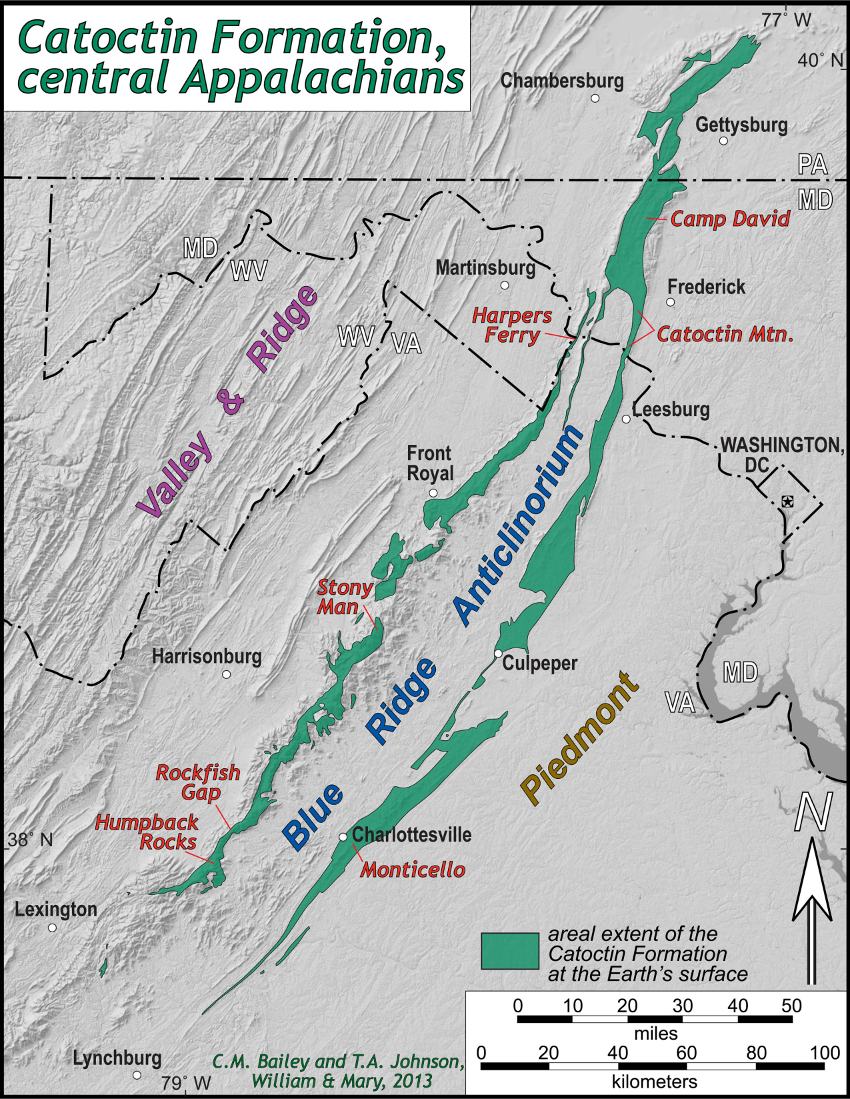
Figure 1. Map illustrating the distribution of the Catoctin Formation in the central Appalachians.
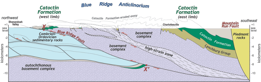
Figure 2. Blue Ridge cross section in central Virginia, note the Catoctin Formation is exposed in both a western and eastern belt. Points X (hanging wall cutoff) and X’ (footwall cutoff) were originally connected prior to slip along the Blue Ridge fault system.
Prior to late Paleozoic contractional deformation in the central Appalachians, the Catoctin Formation (a.k.a- Catoctin volcanic province) occupied a far larger area. We estimate the orginal areal extent of the Catoctin Formation by retrodeforming rocks in the Blue Ridge and Piedmont provinces. By way of example, Catoctin metabasalts are exposed both at Monticello in the eastern Blue Ridge and at Rockfish Gap in the western Blue Ridge, a distance of 38 km apart (Fig. 1). Before Paleozoic deformation, Catoctin metabasalts at these respective locales were ~55 km apart, and located some 70 to 120 km to the southeast of their present location (Fig. 3). The original extent of the Catoctin Formation is far more expansive than its current outcrop belt, occupying an area greater than 30,000 km2.
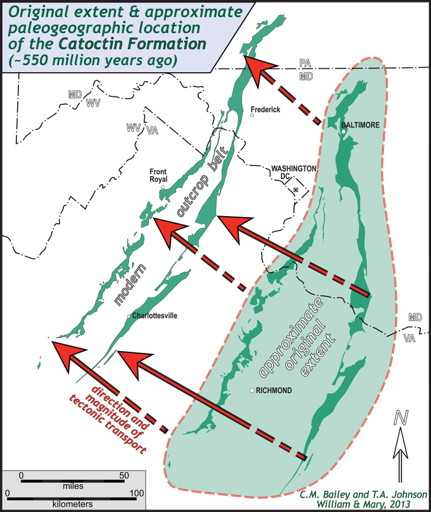
Figure 3. Palinspastic restoration of the original extent and location (plotted with modern geography) of the Catoctin Formation, central Appalachians.
The Catoctin Formation is composed primarily of metabasalt, commonly a greenstone with chlorite, actinolite, and epidote overprinting the original igneous mineralogy. The Catoctin Formation also contains discontinuous layers of metasedimentary rock (including phyllite, quartzite, and rare marble), as well as volcanic breccia, and metarhyolite. At many locations the metabasalt reveals its igneous heritage with well-preserved feldspar phenocrysts and vesicles. Most vesicles are filled with secondary minerals, such as quartz or epidote, and thus amygdules. Vesicular and amygdaloidal basalts occur throughout the Catoctin Formation, and typically delineate the tops of individual lava flows.
As Catoctin lavas cooled, columnar joints developed in many flows (Fig. 4a). These columns are common in the Catoctin Formation’s western outcrop belt and consistent with subaerial extrusion. In contrast, at a number of outcrops in the eastern Blue Ridge, pillow lavas are preserved in the Catoctin metabasalt (Fig. 4b). Catoctin lavas in the eastern Blue Ridge were extruded into a subaqueous environment, perhaps beneath the waters of a nascent ocean.
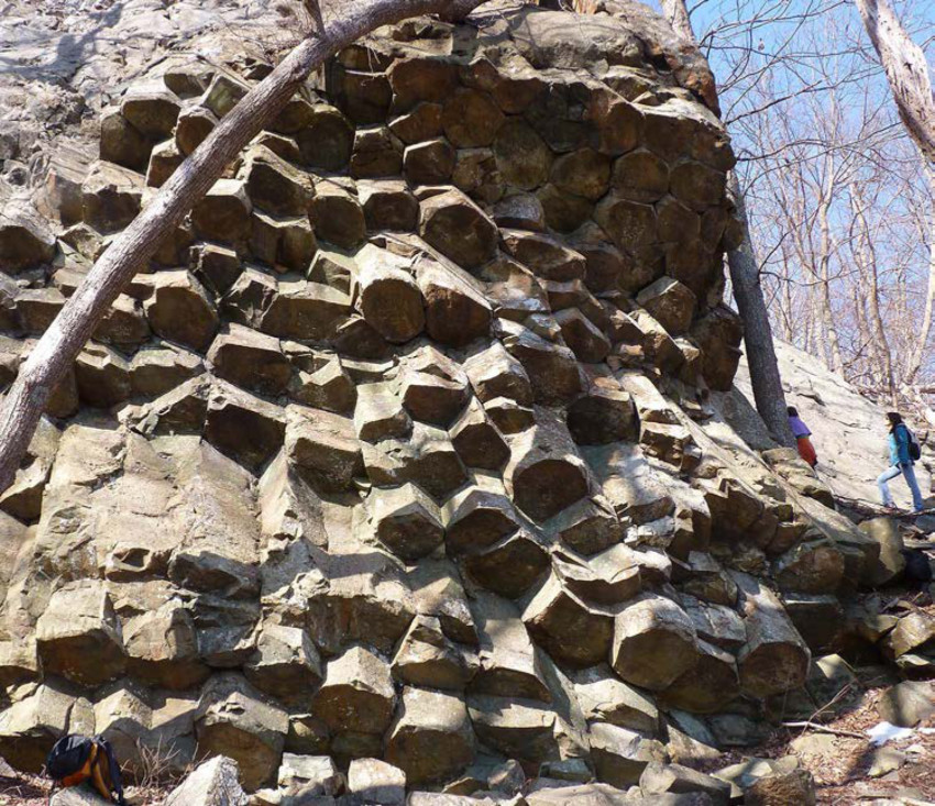
Figure 4. A) Columnar joints in the Catoctin Formation exposed in Shenandoah National Park from the western Blue Ridge.
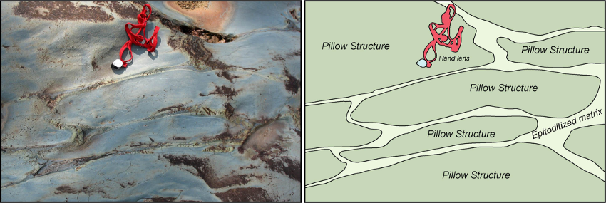
Figure 4. B) Pillow structures in the Catoctin Formation from the eastern Blue Ridge in central Virginia.
Catoctin metabasalts are tholeiitic, typically with low-Mg, high-Ti, and uniform rare-earth element (REE) patterns that are moderately light-REE enriched (Badger and Sinha, 2004; Johnson et al., 2013). Trace element compositions consistently plot in the within-plate basalt field on several standard tectonic discriminant diagrams.
Metabasalt dikes intrude and cut older 1.0 to 1.2 Ga granitic and gneissic rocks in the Blue Ridge (Fig. 5). In rare cases these feeder dikes can be traced upward into metabasalt flows that covered the granitic rocks. The Catoctin metabasalts are overlain by the Chilhowee Group, a sequence of siliciclastic sedimentary rocks that contains fossils, including a partial Hyolithid, the resting trace of a trilobite, and the trace fossil Skolithos. These fossils are characteristic of sediments deposited during the early Cambrian period 520 to 540 million years ago (Simpson and Sundberg, 1987).
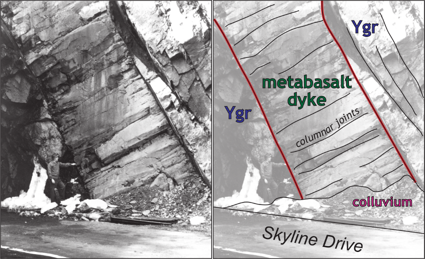
Figure 5. Metabasalt dike cutting granitic basement rocks (Ygr). West side of the north portal at Mary’s Rock Tunnel along the Skyline Drive, Shenandoah National Park. Modified from Reed (1969).
Badger and Sinha (1988) report a Rb/Sr age of 570 ± 36 Ma for the Catoctin Formation (Fig. 6). In northern Virginia, western Maryland, and southern Pennsylvania, metarhyolite is interlayered with the metabasalt. Aleinikoff et al. (1995) and Southworth et al. (2009) obtained U-Pb zircon ages between 550 to 570 Ma from metarhyolites in the Catoctin Formation (Fig. 6). Although it has become clear that the Catoctin volcanics were extruded during the Edicaran, there remains uncertainity as to the duration of Catoctin magmatism.
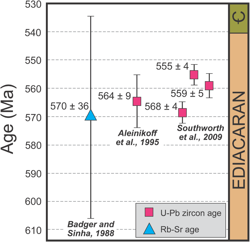
Figure 6. Isotopic ages and their associated uncertainties for the Catoctin Formation.
Metarhyolites in the Catoctin Formation may represent either heavily fractionated components of the original mantle melt or associated crustal melts resulting from the emplacement of magma into the upper crust. The limited geographic extent of metarhyolites in the Catoctin Formation is puzzling. Based upon textural evidence, the Catoctin metarhyolites were likely expelled as viscous glassy lava flows and welded tuffs (Fauth, 1978). The discontinuous nature and apparent thinning of the metarhyolite beds towards the southwest are indictative of a small-scale volcanic event at a single eruptive center near the northern terminus of the outcrop belt.
The Catoctin Formation is a continental flood basalt associated with late stage rifting of Rodinia and development of the Iapetus Ocean. In the case of the Catoctin Formation, more than 30,000 cubic kilometers of lava were extruded in a few million years. Although the origin of flood basalts is widely debated, the most common explanation involves a combination of decompressional melting due to both continental rifting and the rise of a hot and expansive mantle plume.
The Iapetus Ocean formed between the eastern edge of the Laurentian craton, and amalgam of tectonic blocks that would eventually become Gondwana (Fig. 7). Catoctin magmatism in southeastern Laurentia may have facilitated the opening of Iapetus Ocean, and the easternmost flows in the Catoctin Formation likely extruded in a marine setting, while contemporaeous basalts to the west, blanketed the exposed and rifted continental margin.
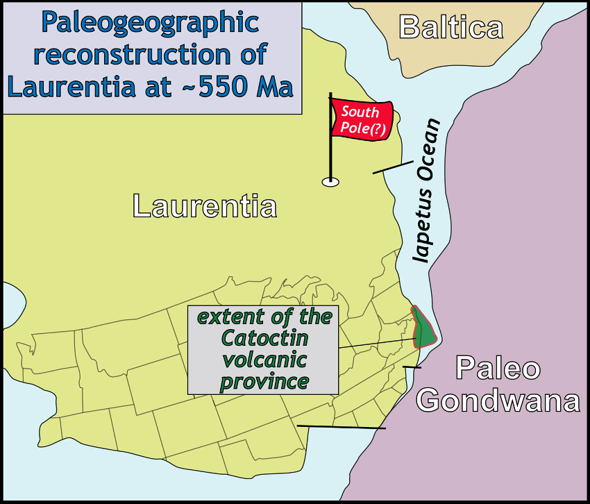
Figure 7. Paleogeographic reconstruction of Laurentia and surrounding continents at ~550 Ma. Note Laurentia was in the southern hemisphere (data from numerous sources including Mitchell et al., 2011).
Although Catoctin volcanism on its own does not reach the minimum size of 100,000 cubic kilometers for a Large Igneous Province (LIP) (e.g. Ernst, 2014) it is part of a regional intraplate multi-pulsed LIP. The Catoctin volcanism represents one pulse of the Central Iapetus Magmatic Province (CIMP) which is distributed along the eastern Laurentian margin and in formerly attached Baltica (e.g. Puffer 2002; McCausland et al. 2007; Ernst and Bell, 2010) and has main pulses at ca. 615 Ma, 590 Ma, 560 and 550 Ma. CIMP is linked to a mantle plume and associated with progressive breakup of the eastern Laurentian margin.
Paleomagnetic analysis of the Catoctin Formation (Meert et al., 1994) places Laurentia at the South Pole at the end of the Neoproterozoic, and the central Appalachian region at high southerly latitudes, although the results are complicated by the thermal overprint from Paleozoic regional metamorphism and deformation.
This contribution was modified from: The Catoctin Formation — Virginia is for Lavas
http://geology.wm.edu/bailey/CatoctinFormation.pdf
Click to open/close ReferencesReferences
Aleinikoff, J.N. Zartman, R.E., Walter, M., Rankwin, D.W., Lytlle, P.T., and Burton, W.C., 1995, U-Pb ages of metarhyolites of the Catoctin and Mount Rogers Formation, central and southern Appalachians: evidence for two pulses of Iapetan rifting: American Journal of Science, v. 295, p. 428-454.
Badger, R.L., and Sinha, A.K., 1988, Age and Sr isotopic signature of the Catoctin volcanic province: Implications for the subcrustal mantle evolution: Geology, v. 16, p. 692-695.
Badger, R.L., and Sinha, A.K., 2004, Geochemical stratigraphy and petrogenesis of the Catoctin volcanic province, central Appalachia, in Tollo, R.P., Corriveau, L., McLelland, J., and Bartholomew, M.J., eds., Proterozoic Tectonic Evolution of the Grenville Orogen in North America: Geological Society of America Memoir 197, p. 435-458.
Ernst, R.E., 2014, Large Igneous Provinces, Cambridge University Press, 653 p.
Ernst, R.E., Bell, K., 2010, Large Igneous Provinces (LIPs) and carbonatites. Mineralogy and Petrology, v. 98, p. 55–76.
Fauth, J. L., 1978, Geology and mineral resources of the Iron Springs area, Adams and Franklin Counties, Pennsylvania: Pennsylvania Geological Survey, v. 4, Atlas 129c, 72 p.
Johnson, T.A, Owens, B.O., and Bailey, C.M., 2013, Geology of the Catoctin Formation in the eastern Blue Ridge, central Virginia: stratigraphy, geochemistry, and petrogenesis: Geological Society of America Abstracts with Programs, v. 45, n. 2, p. 62.
McCausland, P.J.A., Van der Voo, R., Hall, C.M., 2007, Circum-Iapetus paleogeography of the Precambrian-Cambrian transition with a new paleomagnetic constraint from Laurentia. Precambrian Research, v. 156, p. 125–152
Meert, J.G., Van der Voo, R., and Payne, T.W., 1994, Paleomagnetism Of The Catoctin Volcanic Province: A New Vendian-Cambrian apparent polar wander path for North-America: Journal Of Geophysical Research—Solid Earth, v. 99, n. B3, p. 4625– 4641.
Puffer, J.H., 2002, A late Neoproterozoic eastern Laurentian superplume: Localization, size, chemical composition, and environmental impact: American Journal of Science, v. 302, p. 1-27.
Reed, J.C., Jr., 1969, Ancient Lavas in Shenandoah National Park near Luray, Virginia” U. S. Geological Survey Bulletin 1265, 35 p.
Mitchell, R.N., Kilian, T.M., Raub, T.D., Evans, D.A.D., Bleecker, W., and Maloof, A.C., 2011, Sutton hotspot: resolving Ediacaran-Cambrian tectonics and true polar wander for Laurentia: American Journal of Science, v. 311, p. 651– 663,
Simpson, E.L., and Sundberg, F.L., 1987, Early Cambrian age from synrift deposits of the Chilhowee Group of southwestern Virginia: Geology, v. 15, p. 123-126.
Southworth, S., Aleinikoff, J.N., Bailey, C.M., Burton, W.C., Crider, E.A., Hackley, P.C., Smoot, J.P., and Tollo, R.P., 2009, Geologic map of the Shenandoah National Park region Virginia: U.S. Geological Survey Open-File Report 2009–1153, 96 p., 1 plate, scale 1:100,000.