August 2016 LIP of the Month
The Cretaceous Wallaby Plateau Igneous Province: a small oceanic plateau or submerged continental flood basalt?
Hugo K.H. Olierook 1,2,*, Renaud E. Merle 3, Fred Jourdan 1,4
1Department of Applied Geology, Curtin University, GPO Box U1987, Perth, WA 6845, Australia
2Department of Earth, Ocean and Ecological Sciences, University of Liverpool, 4 Brownlow Street, Liverpool, L69 3GP, United Kingdom
3Research School of Earth Sciences, Australian National University, 142 Mills Road, Acton, ACT 0200, Australia
4Western Australian Argon Isotope Facility & JdL Centre, Curtin University, GPO Box U1987, Perth, WA 6845, Australia
Emails: H.Olierook@liverpool.ac.uk; Renaud.Merle@anu.edu.au; F.Jourdan@curtin.edu.au
Introduction
The Wallaby Plateau, also known as the Cuvier Plateau, is a ~70,000 km2 bathymetric high situated some 500 km from the northwest coast of Australia that rifted from continental Australia during the breakup of Gondwana in the Early Cretaceous (Fig. 1). Although estimates vary, the volume of magmatism that erupted on and intruded into the Wallaby Plateau in the Cretaceous was not what is classically regarded as a “large igneous province”. Large igneous provinces (LIPs) are usually mafic provinces with areal extents of >100,000 km2 and magmatic volumes of >100,000 km3, but are commonly in excess of 1,000,000 km3 (Ernst 2014). In contrast, the volume of the Wallaby Plateau Igneous Province is debatable, but seismic constraints such as those presented in Figure 2 place the volume somewhere in the range of 30,000–300,000 km3, but most likely below 100,000 km3 (Goncharov and Nelson, 2012; Olierook et al., 2015a). Do the mechanisms of typical LIP formation apply to moderately-sized igneous provinces such as the Wallaby Plateau?
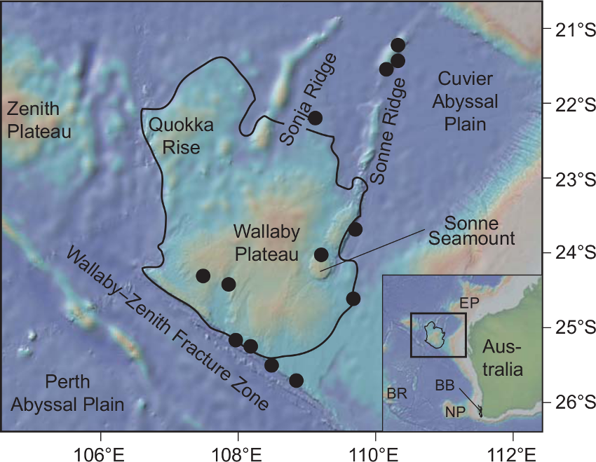
Figure 1: Bathymetric map by of the Wallaby Plateau off northwest Australia with geomorphic features and numbered sample sites from expeditions in 1979, 1990 (Colwell and Graham, 1990) and 2008/09 (Daniell et al., 2009), after (Olierook et al., 2015a; Olierook et al., 2015b). BB—Bunbury Basalt; BR—Broken Ridge; EP—Exmouth Plateau; NP—Naturaliste Plateau.
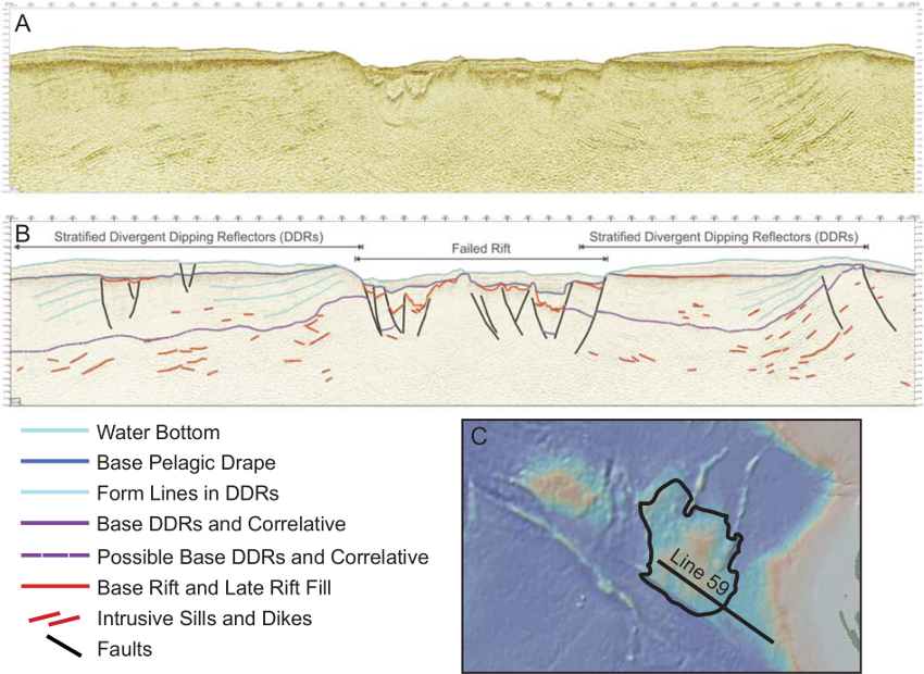
Figure 2:(A) Processed and (B) Interpreted seismic reflection profile from line 59, trending NW–SE from the Wallaby Plateau to Australian continental shelf (modified from Goncharov and Nelson, 2012).
Geological setting
The Wallaby Plateau is one of several marginal plateaus that lie off the continental margin of Western Australia. The plateau ranges in depth from ~2000 m at its crest to ~4000 m at its edges. Falvey and Veevers (1974) first attempted to describe the physiography of the Wallaby Plateau on the basis of a single-channel seismic line recorded by the Glomar Challenger in 1972 and extrapolative data from the nearby Exmouth and Scott plateaus. The Plateau comprises two bathymetric highs; a larger plateau to the south that was coined the Wallaby Plateau by Veevers et al. (1985) and a smaller mound to the northwest that was called the Quokka Rise (Fig. 1). Two ridges propagate NNE into the Cuvier Abyssal Plain from the northern margin of the Wallaby Plateau. The origins of the two ridges – the Sonne and Sonja ridges – are considered to be either pseudofaults or abandoned spreading ridges (Mihut and Müller, 1998; Robb et al., 2005). The Wallaby Plateau is separated by continental Australia to the east by a shallow basin called the Wallaby Saddle. The Wallaby Plateau is separated from the Zenith Plateau to the west by another shallow basin. The Wallaby Plateau is bound to the north by the Cuvier Abyssal Plain and to the south by the Perth Abyssal Plain. The southern margin is particularly dramatic where the steep, 2000 m high Wallaby–Zenith Fracture Zone marks a clear divide between the Perth Abyssal Plain and Wallaby Plateau (Fig. 1). Both the Cuvier and Perth abyssal plains record Early Cretaceous M-series magnetic anomalies. The two abyssal plains probably opened a few million years prior to the recording of magnetic anomaly M10N at ca. 134 Ma (Gibbons et al., 2013; Gradstein et al., 2012; Mihut and Müller, 1998; Robb et al., 2005).
Early hypotheses of the origins of the Wallaby plateau
Exploration of the Wallaby Plateau has been limited to a handful of marine expeditions. Two hypotheses for its genesis were first proposed in the late 1970s. Symonds and Cameron (1977) interpreted the Wallaby Plateau as a continental fragment that failed to completely detach from the Australian continent. Conversely, Veevers and Cotterill (1978) suggested that the Wallaby Plateau was a 2–4 km thick oceanic plateau that formed on oceanic crust soon after the start of spreading between Greater India and Australia (Larson et al., 1978; Larson et al., 1979). Both theories were soon put to the test by the first targeted expedition to the Wallaby Plateau in 1979 by the RV Sonne. Dredging of volcanic rocks on its eastern and southern margin recovered mafic volcanic rocks and volcaniclastic rocks that were geochemically similar to other intraplate oceanic plateaus (Coleman et al., 1982; von Stackelberg et al., 1980). Thus, an oceanic origin for the Wallaby Plateau became the favoured model. However, von Stackelberg et al. (1980) could not exclude the possibility of a continental origin for the Wallaby Plateau. An attempt was also made at dating the rocks via K-Ar dating. An apparent Late Cretaceous age of 89 Ma was obtained on an altered basalt sample along the Wallaby–Zenith Fracture Zone, but it was appreciated that the K-Ar age was only a minimum age due to the high degree of alteration (von Stackelberg et al., 1980).
Geophysical data associated with the RV Sonne expedition were soon after processed and published in the 1980s that indicated that magmatism on the Wallaby Plateau was not limited to lava flows but rather a combination of extrusive, intrusive and underplated igneous rocks (Mutter et al., 1988; Veevers, 1984; von Rad and Exon, 1983). Together with the nearby Exmouth and Scott plateaus, and hypotheses about the Zenith Plateau and the nature of seaward dipping reflectors in sedimentary basin off the continental shelves, the (north)western Australian margin became to be considered a ‘volcanic’ passive margin. However, the lack of proof for or against a continental basement of the Wallaby Plateau sparked a second expedition was conducted by the Australian Geological Survey Organisation (now Geoscience Australia) in 1990 (Colwell and Graham, 1990). Several authors in the 1990s considered the oceanic plateau hypothesis first put forward by Veevers and Cotterill (1978) to be valid on the basis on the basis of seismic reflection data and dredged mafic rocks (Colwell et al., 1994; Mihut and Müller, 1998). Planke et al. (1996) instead likened the northwest Australian seismic volcanostratigraphy to better-known examples in the North Atlantic. Planke et al. (1996) instead suggested the plateau to be comprised of a basement of attenuated continental crust intruded by magmatic bodies and blanketed by basaltic extrusive bodies, the latter of which were sampled in dredges in 1979 and 1990. Symonds et al. (1998) agreed with this continental hypothesis, but added that it developed as a result of the transform margin development as Greater India slid past Australia.
Evidence of a continental origin
By the turn of the millennium, we were no closer to deciphering the continental vs. oceanic origin of the Wallaby Plateau. At least by now, it was appreciated that the volume of magma was extensive with or without a continental core but not as large as typical large igneous provinces (Symonds et al., 1998). The potential of continental crust also opened the possibility of pre-breakup sedimentary successions that could host hydrocarbons. This led to renewed interest into the Wallaby Plateau, amongst other regions on the western Australian margin, and a third expedition was undertaken in 2008/09 (Daniell et al., 2009) – and this time, the evidence originating from the expedition overwhelmingly favoured a continental origin for the Wallaby Plateau.
Unfortunately, the holy grail of a continental origin – the procurement of in situ continental rocks – were still not dredged on this expedition, but other elements conclusively supported the presence of underlying continental crust. Perhaps most striking is the recovery of fossiliferous rocks that provided Late Jurassic and Early Cretaceous macrofauna, microfauna and palynomorphs that proved the existence of the Wallaby Plateau prior to the breakup of Gondwana (Quilty, 2011; Stilwell et al., 2012). Furthermore, the fossil assemblage was clearly of a shallow marine origin, indicating that the Wallaby Plateau was emergent to shallowly submerged between the latest Jurassic and the Aptian (Quilty, 2011; Stilwell et al., 2012). Three-dimensional gravity and magnetic inversion of the plateau by Goodwin et al. (2015) found two cores of low-density crust, similar to that of continental crust. Goodwin et al. (2015) found it was not possible to model the Wallaby Plateau as only comprising a volcanic core and an overlying volcanosedimentary sequence, providing further support for a continental origin. Lastly, evidence of continental crustal contamination in tholeiitic basalts was presented by Dadd et al. (2015) and Olierook et al. (2015a), providing further evidence of the presence of a continental core (Fig. 3). Thus, it became clear the Wallaby Plateau igneous province was a continental flood basalt rather than an oceanic plateau – at least in genesis, if not in volumetric scale.
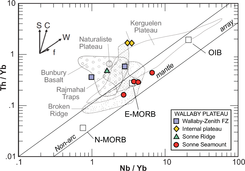
Figure 3: Nb/Yb vs Th/Yb discrimination diagram. Arrows after Pearce and Peate (1995) show the variation that is produced by S—addition of subduction-related components, C—addition of crustal components; W—within plate processes, and f—fractionation. Variation in samples from the Sonne Seamount is parallel to vector ‘f’. Samples from the Wallaby Plateau, Zenith Fracture Zone and Exmouth Basin are removed from the array along the vector S or C, suggesting a subduction-related component in the source or crustal contamination.
Using seismic constraints from Goncharov and Nelson (2012), Olierook et al. (2015a) estimated the combined volume of blanketing volcanosedimentary sequence and seaward dipping reflectors to be 320,000 km3 (Fig. 2). Using gravity inversion and seismic wavelet constraints, it is estimated that between 10 to 90% of this volume comprises magmatic rocks, but it is likely that this is at the lower end of the spectrum under 100,000 km3 (Goncharov and Nelson, 2012). Although the western Australian margin is classically considered a volcanic passive margin (Coffin and Eldholm, 1992, 1994), such volumes are difficult to categorise into ‘volcanic’ and ‘non-volcanic’ endmembers of passive margin breakup. Testing what mechanisms were responsible for the magmatism on the Wallaby Plateau required an understanding of the geochronology and isotope geochemistry of the magmatic rocks, which are covered in the following sections.
Age of magmatism on the Wallaby plateau
Although a minimum K-Ar age of 89 Ma was obtained by von Stackelberg et al. (1980), the first and, to date, only reliable ages were reported in Olierook et al. (2015a). A combination of U-Pb and 40Ar/39Ar geochronology found that at least a portion of the Wallaby Plateau along the Wallaby–Zenith Fracture Zone erupted at ca. 124 Ma. Two volcaniclastic samples yielded 206Pb/238U yielded concordant ages of 123.9 ± 1.0 Ma and 123.9 ± 1.3 Ma excluding inherited zircon grains that were older than 400 Ma (Fig. 4; Olierook et al., 2015a). A third sample yielded similar spot-ages between 135 and 120 Ma but failed to yield a statistically reliable age (Fig. 4). The 40Ar/39Ar results were more problematic to interpret. Two samples that were collected further west along the Wallaby–Zenith Fracture Zone than those that U-Pb ages were obtained from yielded precise plateau ages at 125.12 ± 0.90 Ma and 123.8 ± 1.0 Ma (Fig. 5; Olierook et al., 2015a). However, the plagioclase separates exhibited abnormally high K/Ca ratios; such ratios are impossible in pristine plagioclase but in the realm of its altered product, sericite. Thus, poor sample preparation yielded not the plagioclase crystallisation ages but the alteration of plagioclase to sericite. Where pristine plagioclase picks were evident from a normal K/Ca ratio expected for plagioclase, the ages were imprecise because of insufficient potassium. Ages of 120 ± 14 Ma and 123 ± 11 Ma were obtained from the Sonne Ridge, again, pointing to an Early Cretaceous crystallisation age but precluding further interpretation (Fig. 5). Olierook et al. (2015a) concluded that a significant portion of the Wallaby Plateau erupted at 124 Ma, but it remained uncertain whether coeval hydrothermal activity reset the chronometers of potentially significantly older volcanism or whether the alteration event was coeval with the eruptions at 124 Ma.
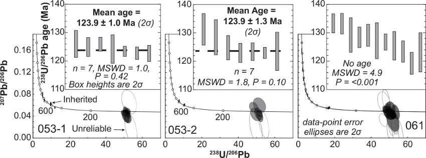
Figure 4: Tera–Wasserburg inverse concordia plots for zircon populations. Insets show weighted average ages based on 206Pb/238U for zircons younger than 400 Ma (Olierook et al., 2015a).
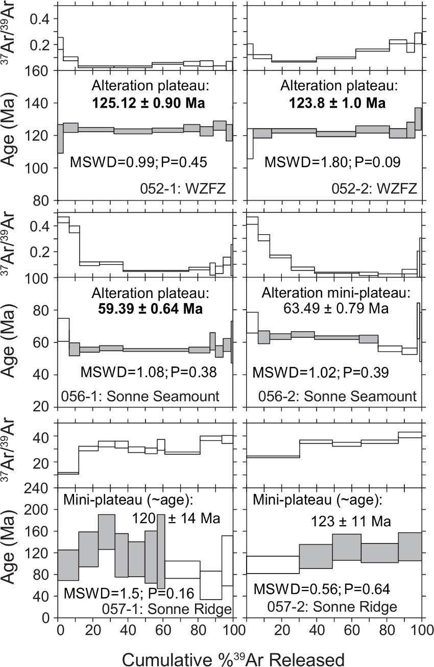
Figure 5: 40Ar/39Ar apparent age and related 37Ar/39Ar ratio spectra (proxy for K/Ca ratio) of the plagioclase separates versus the cumulative percentage of 39Ar released (Olierook et al., 2015a). Steps included in the plateau (>70% 39Ar released) and mini-plateau (50%–70% 39Ar released) age calculation are shaded gray. Errors on plateau and mini-plateau ages are quoted at 2σ.
Two other 40Ar/39Ar ages were much younger than expected on a seamount located on the Sonne Ridge (Fig. 5). The aptly-named Sonne Seamount yielded a plateau age of 59.39 ± 0.64 Ma and a mini-plateau age of 63.49 ± 0.79 Ma (Olierook et al., 2015a). Again, high K/Ca ratios indicate that both ages were obtained on sericite rather than plagioclase so the crystallisation of these rocks may be as old as the Early Cretaceous rocks. However, what is clear is that the Wallaby Plateau experienced a hydrothermal alteration event around 60 Ma.
Geochemical signatures and petrogenesis
Geochemical analyses were performed on volcanic samples from all three expeditions (Colwell et al., 1994; Dadd et al., 2015; Olierook et al., 2015a; von Stackelberg et al., 1980). von Stackelberg et al. (1980) first reported the recovery of tholeiitic basalts from the Wallaby Plateau. Volcanic breccias and volcaniclastic sandstone containing clasts of tholeiitic basalts, and tuff were also recovered during the RV Sonne dredges in 1979. However, the geochemical analysis was otherwise limited and no further was commented on the geochemical nature of the Wallaby Plateau.
After more dredged were hauled in 1990, Colwell et al. (1994) analysed the major, trace and rare earth element geochemistry of two volcanic samples and further interpreted the work of von Stackelberg et al. (1980). Colwell et al. (1994) found that the Wallaby Plateau tholeiitic basalts were very similar in chemistry to other eastern Gondwanan intraplate volcanism, including the Bunbury Basalt, Naturaliste Plateau, Broken Ridge and Kerguelen Plateau (Davies et al., 1989; Frey et al., 1996; Mahoney et al., 1995; Pyle et al., 1995; Storey et al., 1992). Although the geochemical similarity was striking between these provinces, Colwell et al. (1994) could not reconcile the petrogenesis of the Wallaby Plateau igneous province with the other provinces. The genesis of the Bunbury Basalt (see discussion by Olierook et al., 2016), Naturaliste Plateau, Broken Ridge and Kerguelen Plateau were all attributed to the Kerguelen mantle plume. However, the distance between the centre of the mantle plume head and the Wallaby Plateau exceeding 1000 km, making the plume’s contribution to the Wallaby Plateau igneous province unlikely, a theory that was also supported by Hopper et al. (1992). In the following decade, despite various refinements of the moving and fixed mantle plume heads, the Kerguelen mantle plume remained too distal from the Wallaby Plateau (Antretter et al., 2002; O'Neill et al., 2003). A synthesis of the Kerguelen mantle plume output through time by Coffin et al. (2002) concluded three decades of sampling and agreed that the Wallaby Plateau was not derived from the Kerguelen mantle plume. Other explanations needed to be sought for the geochemical similarity between the Wallaby Plateau and other western Australian and eastern Indian Ocean magmatic provinces.
By the mid-2000s, Sr, Nd and Pb isotope geochemical analyses had been obtained for all the Kerguelen plume-attributed provinces, but isotope geochemistry remained absent for Wallaby Plateau. It was not until the Geoscience Australia expedition in 2008/09 that, in addition to major, trace and rare earth elements, Sr and Nd isotopes were first analysed (Dadd et al., 2015; Olierook et al., 2015a). Analysed tholeiitic basalts were, again, comparable to continental tholeiitic basalts and yielded Sr-Nd isotopes with enriched mantle signatures (Fig. 6). The combination of enriched mid-ocean ridge like REE patterns with depleted Nb, low Nb/Zr, low Nb/La, low 143Nd/144Nd and high 87Sr/86Sr, yet without striking evidence of continental crust contamination indicate a shallow sub-continental lithospheric rather than an asthenospheric source (Fig. 7; Dadd et al., 2015). We note that the rocks on which the geochemistry and geochronology was performed on by Olierook et al. (2015a) and Dadd et al. (2015), respectively, were not the same. Thus, it is possible that the geochronology and geochemical data are not directly linked.
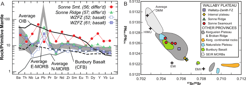
Figure 6: (A) Primitive mantle normalized incompatible element patterns. Primitive mantle normalization, average ocean island basalt (OIB), enriched mid-oceanic ridge basalt (E-MORB), and normal MORB (N-MORB) values from Sun and McDonough (1989). Bunbury Basalt data are from Frey et al. (1996) and Olierook et al. (2016). (B) 87Sr/86Sr(initial) versus 143Nd/144Nd(initial) for volcanic rocks from the Wallaby Plateau. Data for HIMU, DMM, EMI and EMII (all present-day values) is from Zindler and Hart (1986). Compilation of geochemical data from other provinces is from Olierook et al. (In prep.).
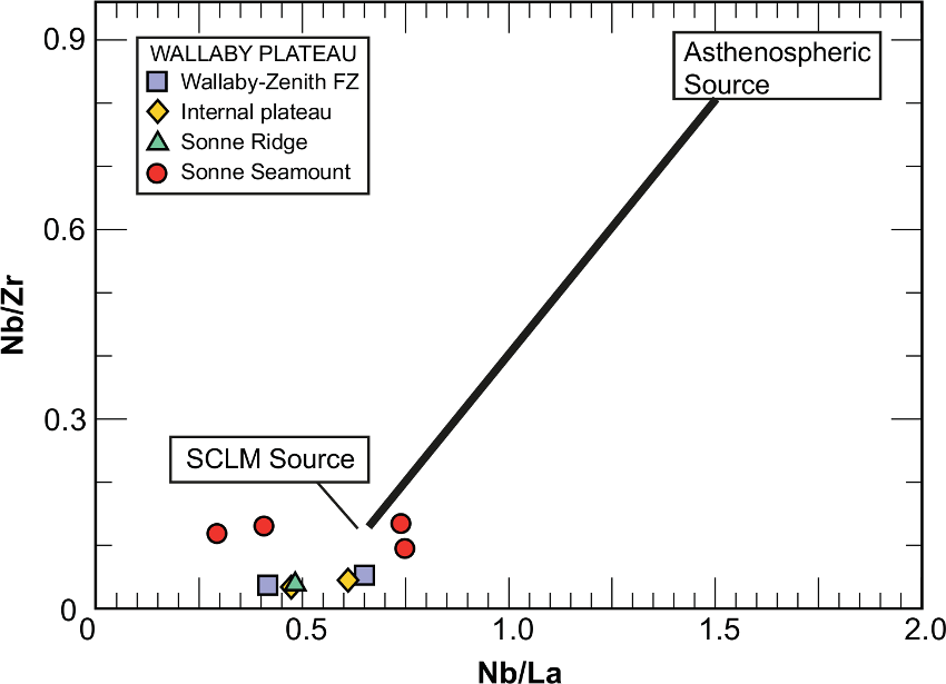
Figure 7: Nb/La vs. Nb/Zr discrimination diagram showing the likelihood of a subcontinental lithospheric mantle source (SCLM) for all Wallaby Plateau samples, after Dadd et al. (2015).
Plate reconstruction modelling by Olierook et al. (2015a) using the plate reconstruction framework from Seton et al. (2012) modified for the Indian Ocean (Whittaker et al., 2013) showed that the proto-Indian Ocean opened south of the Wallaby Plateau at about 124 Ma (Fig. 8). On the available geochemical, age and plate reconstruction evidence, Olierook et al. (2015a) concluded that the volcanism that spread across the Wallaby Plateau at ca. 124 Ma was only made possible by the opening of the Indian Ocean. The thickness of the continental crust beneath the Wallaby Plateau perhaps caused some magmatism to underplate, but the opening of the Indian Ocean provided a vertical pathway through the lithospheric-scale Wallaby–Zenith Fracture Zone. It is worth noting that an equivalent magmatic province may be present on the conjugate Indian margin, but this portion of the Indian Plate is now deeply subducted under the Eurasian Plate and, as a result, is inaccessible (Ali and Aitchison, 2014; Capitanio et al., 2010). In any case, this study favours a subcontinental lithospheric mantle-derived source volcanism caused by the opening of the Indian Ocean that was, perhaps, abetted by edge-driven convection (King and Anderson, 1998) at the Indian–Australian continent–continent boundary (Olierook et al., 2015a).
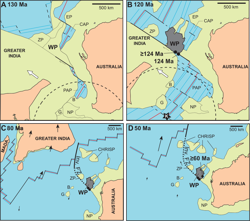
Figure 8: Plate reconstructions during the breakup of Greater India from the Austral–Antarctic portion of Gondwana, modified from Gibbons et al. (2012) and Olierook et al. (2015a). B—Batavia Knoll; CAP—Cuvier Abyssal Plain; CHRISP—Christmas Island Seamount Province; EP—Exmouth Plateau; G—Gulden Draak Knoll; Inv. FZ—Investigator Fracture Zone; PAP—Perth Abyssal Plain; MADA.—Madagascar; NP—Naturaliste Plateau; WP—Wallaby Plateau; ZP—Zenith Plateau.
In addition to the ~124 Ma tholeiitic basalts, samples with ocean island basalt affinity were collected from the min. 60 Ma Sonne Seamount (Fig. 6; Dadd et al., 2015; Olierook et al., 2015a). Crustal contamination of these samples is negligible (Fig. 3), implying that these rocks are different from the ~124 Ma samples. This inference is important because it implies that 60 Ma hydrothermal event was not simply a result of altering ~124 Ma volcanic rocks, but rather that the rocks were significantly younger. Discrimination diagrams (Nb/Zr versus Nb/La) indicate that a subcontinental lithospheric mantle source is likely for the Sonne Seamount samples but the question remained what geodynamic evidence there was for such a hydrothermal and/or magmatic event at ~60 Ma (Fig. 7; Dadd et al., 2015). Olierook et al. (2015a) note that the closest magmatic activity at ~60 Ma are located in the Christmas Island Seamount Province (Hoernle et al., 2011), which formed less than 1000 kilometres away from the Sonne Seamount (Fig. 8). The petrogenesis of the Christmas Island Seamount Province – by shallow recycling of continental lithosphere – could well have resulted in a larger halo of magmatic activity (Hoernle et al., 2011). The volcanism on the Sonne Seamount probably utilised the established and previously-used vertical pathway through the Sonne Ridge. More seamounts on the Sonne and Sonja ridges may still be discovered in the future because of the lack of bathymetric data over large parts of the Wallaby Plateau (Daniell et al., 2009). However, the total volume attributed to post-breakup volcanism would still be minor compared to the volcanism that occurred during the opening of the Indian Ocean.
Lastly, the adjacent Zenith Plateau immediately the northwest of the Wallaby Plateau (Fig. 1) may have a comparable genesis to its neighbour. The Zenith Plateau has been given very little attention. Recent bathymetric mapping on the Zenith Plateau in light of the MH370 airplane search is the only appreciable exploration ever from the plateau. We speculate that the ~50,000 km2 Zenith Plateau may also be a continental fragment and may equally be overlain by volcanism during the opening of the Indian Ocean, perhaps erupting between ca. 115–105 Ma. Alternatively, the majority of the Zenith Plateau could also have been covered by the volcanism at ca. 124 Ma and the Zenith Plateau continental fragment only later detached from the Wallaby Plateau. If the latter is true, the Wallaby and Zenith Plateau could be part of the same province and may nearly double the volcanic volume. Thus, in addition to the Zenith Plateau and the conjugate Indian margin, the Wallaby Plateau Igneous Province may well be of large igneous province scale.
Conclusions
The Wallaby Plateau Igneous Province is a moderately-sized continental flood basalt that largely erupted during the Cretaceous at and perhaps slightly before ~124 Ma. Volumetric estimates place the total magmatic volume of the 70,000 km2 plateau between 30,000 and 300,000 km3, but more likely below 100,000 km3. Together with potential coeval volcanism on the adjacent Zenith Plateau and conjugate Indian continent, the total volcanism could exceed 100,000 km3 and be categorized as a large igneous province, but this remains unsubstantiated. Geochemical results show that a subcontinental lithospheric mantle source is the best explanation for the genesis of the bulk of the Wallaby Plateau igneous province. A small volumetric contribution is provided at ~60 Ma or slightly earlier by way of the Sonne Seamount, which is potentially related to eruptions at the then-proximal Christmas Island Seamount Province. However, plate reconstruction modelling coupled with the geochemical and geochronological data indicate that the bulk of the volcanism at 124 Ma occurred as a result of the Indian Ocean opening to the south of the Wallaby Plateau along the Wallaby–Zenith Fracture Zone as Greater India slid past Australia.
Click to open/close ReferencesReferences
Ali, J.R., Aitchison, J.C., 2014. Greater India's northern margin prior to its collision with Asia. Basin Research 26, 73-84.
Antretter, M., Steinberger, B., Heider, F., Soffel, H., 2002. Paleolatitudes of the Kerguelen hotspot: new paleomagnetic results and dynamic modeling. Earth and Planetary Science Letters 203, 635-650.
Capitanio, F.A., Morra, G., Goes, S., Weinberg, R.F., Moresi, L., 2010. India-Asia convergence driven by the subduction of the Greater Indian continent. Nature Geoscience 3, 136-139.
Coffin, M.F., Eldholm, O., 1992. Volcanism and continental break-up: a global compilation of large igneous provinces. Geological Society, London, Special Publications 68, 17-30.
Coffin, M.F., Eldholm, O., 1994. Large igneous provinces: Crustal structure, dimensions, and external consequences. Reviews of Geophysics 32, 1-36.
Coffin, M.F., Pringle, M.S., Duncan, R.A., Gladczenko, T.P., Storey, M., Müller, R.D., Gahagan, L.A., 2002. Kerguelen hotspot magma output since 130 Ma. Journal of Petrology 43, 1121-1139.
Coleman, P.J., Michael, P.J., Mutter, J.C., 1982. The origin of the Naturaliste Plateau, SE Indian Ocean: Implications from dredged basalts. Journal of the Geological Society of Australia 29, 457-468.
Colwell, J.B., Graham, T.L., 1990. Stratigraphy of Australia's NW Continental Margin (Project 121-26), Research Cruise Proposal (Survey 96). Bureau of Mineral Resource, Geology & Geophysics, Record 1990/43, pp. 1-47.
Colwell, J.B., Symonds, P.A., Crawford, A.J., 1994. The nature of the Wallaby (Cuvier) Plateau and other igneous provinces of the west Australian margin. Journal of Australian Geology and Geophysics 15, 137-156.
Dadd, K.A., Kellerson, L., Borissova, I., Nelson, G., 2015. Multiple sources for volcanic rocks dredged from the Western Australian rifted margin. Marine Geology 368, 42-57.
Daniell, J., Jorgensen, D.C., Anderson, T., Borissova, I., Burq, S., Heap, A., Hughes, M., Mantle, D., Nelson, G., Nichol, S., Nicholson, C., Payne, D., Przeslawski, R., Radke, L., Siwabessy, J., Smith, C., Shipboard Party, 2009. Frontier basins of the west Australian continental margin: post-survey report of marine reconnaissance and geological sampling survey GA2476. Geoscience Australia, Record 2009/38, Canberra, Australia, p. 229.
Davies, H.L., Sun, S.-S., Frey, F.A., Gautier, I., McCulloch, M.T., Price, R.C., Bassias, Y., Klootwijk, C.T., Leclaire, L., 1989. Basalt basement from the Kerguelen Plateau and trail of a Dupal plume. Contributions to Mineralogy and Petrology 103, 457-469.
Ernst, R.E., 2014. Large Igneous Provinces. Cambridge University Press, 653 p.
Falvey, D.A., Veevers, J.J., 1974. Physiography of the Exmouth and Scott Plateaus, Western Australia, and adjacent northeast Wharton Basin. Marine Geology 17, 21-59.
Frey, F.A., McNaughton, N.J., Nelson, D.R., deLaeter, J.R., Duncan, R.A., 1996. Petrogenesis of the Bunbury Basalt, Western Australia: interaction between the Kerguelen plume and Gondwana lithosphere? Earth and Planetary Science Letters 144, 163-183.
Gibbons, A.D., Barckhausen, U., van den Bogaard, P., Hoernle, K., Werner, R., Whittaker, J.M., Müller, R.D., 2012. Constraining the Jurassic extent of Greater India: Tectonic evolution of the West Australian margin. Geochemistry, Geophysics, Geosystems 13, Q05W13.
Gibbons, A.D., Whittaker, J.M., Muller, R.D., 2013. The breakup of East Gondwana: Assimilating constraints from Cretaceous ocean basins around India into a best-fit tectonic model. Journal of Geophysical Research-Solid Earth 118, 808-822.
Goncharov, A., Nelson, G., 2012. From two way time to depth and pressure for interpretation of seismic velocities offshore: Methodology and examples from the Wallaby Plateau on the West Australian margin. Tectonophysics 572–573, 26-37.
Goodwin, J.A., Hackney, R., Williams, N.C., 2015. 3D Geophysical Inversion Modelling of the Wallaby Plateau: Evidence for Continental Crust and Seaward-Dipping Reflectors. Geoscience Australia, Canberra, Australia.
Gradstein, F.M., Ogg, J.G., Schmitz, M.D., Ogg, G.M., (Eds.), 2012. The Geologic Time Scale 2012 2-Volume Set (Vol. 2). Elsevier, Oxford, U.K.
Hoernle, K., Hauff, F., Werner, R., van den Bogaard, P., Gibbons, A.D., Conrad, S., Muller, R.D., 2011. Origin of Indian Ocean Seamount Province by shallow recycling of continental lithosphere. Nature Geosci 4, 883-887.
Hopper, J.R., Mutter, J.C., Larson, R.L., Mutter, C.Z., 1992. Magmatism and rift margin evolution: Evidence from northwest Australia. Geology 20, 853-857.
King, S.D., Anderson, D.L., 1998. Edge-driven convection. Earth Planet Sci Lett 160, 289-296.
Larson, R.L., Carpenter, G.B., Diebold, J.B., 1978. A geophysical study of the Wharton Basin near the Investigator Fracture Zone. Journal of Geophysical Research: Solid Earth 83, 773-782.
Larson, R.L., Mutter, J.C., Diebold, J.B., Carpenter, G.B., Symonds, P., 1979. Cuvier Basin: A product of ocean crust formation by Early Cretaceous rifting off Western Australia. Earth and Planetary Science Letters 45, 105-114.
Mahoney, J.J., Jones, W.B., Frey, F.A., Salters, V.J.M., Pyle, D.G., Davies, H.L., 1995. Geochemical characteristics of lavas from Broken Ridge, the Naturaliste Plateau and southernmost Kerguelen Plateau: Cretaceous plateau volcanism in the southeast Indian Ocean. Chemical Geology 120, 315-345.
Mihut, D., Müller, R.D., 1998. Volcanic margin formation and Mesozoic rift propagators in the Cuvier Abyssal Plain off Western Australia. Journal of Geophysical Research: Solid Earth 103, 27135-27149.
Mutter, J.C., Buck, W.R., Zehnder, C.M., 1988. Convective partial melting. 1. A model for the formation of thick basaltic sequences during the initiation of spreading. Journal of Geophysical Research 93, 1031-1048.
O'Neill, C., Müller, R.D., Steinberger, B., 2003. Geodynamic implications of moving Indian Ocean hotspots. Earth And Planetary Science Letters 215, 151-168.
Olierook, H.K.H., Jourdan, F., Merle, R.E., In prep. Origin and age of the Naturaliste Plateau Igneous Province: Interaction between a long-lived mantle plume and an enriched subcontinental lithospheric mantle in eastern Gondwana? . Geology.
Olierook, H.K.H., Jourdan, F., Merle, R.E., Timms, N.E., Kusznir, N.J., Muhling, J., 2016. Bunbury Basalt: Gondwana breakup products or earliest vestiges of the Kerguelen mantle plume? Earth and Planetary Science Letters 440, 20-32.
Olierook, H.K.H., Merle, R.E., Jourdan, F., Sircombe, K., Fraser, G., Timms, N.E., Nelson, G., Dadd, K.A., Kellerson, L., Borissova, I., 2015a. Age and geochemistry of magmatism on the oceanic Wallaby Plateau and implications for the opening of the Indian Ocean. Geology 43, 971-974.
Olierook, H.K.H., Timms, N.E., Merle, R.E., Jourdan, F., Wilkes, P.G., 2015b. Paleo-drainage and fault development in the southern Perth Basin, Western Australia during and after the breakup of Gondwana from 3D modelling of the Bunbury Basalt. Australian Journal of Earth Sciences 62, 289-305.
Pearce, J.A., Peate, D.W., 1995. Tectonic implications of the composition of volcanic arc magmas. Annual Reviews of Earth and Planetary Sciences 23, 251-285.
Planke, S., Symonds, P., Müller, D., 1996. Formation of volcanic rifted margins and oceanic plateaus: mantle plumes versus non-mantle plume hypothesis on the western Australia volcanic margin, AGU Fall Meeting.
Pyle, D.G., Christe, D.M., Mahoney, J.J., Duncan, R.A., 1995. Geochemistry and geochronology of ancient southeast Indian Ocean and southwest Pacific Ocean seafloor. Journal of Geophysical Research B100, 22261-22282.
Quilty, P.G., 2011. Late Jurassic foraminifera, Wallaby Plateau, offshore Western Australia. The Journal of Foraminiferal Research 41, 182-195.
Robb, M.S., Taylor, B., Goodliffe, A.M., 2005. Re-examination of the magnetic lineations of the Gascoyne and Cuvier Abyssal Plains, off NW Australia. Geophysical Journal International 163, 42-55.
Seton, M., Müller, R.D., Zahirovic, S., Gaina, C., Torsvik, T., Shephard, G., Talsma, A., Gurnis, M., Turner, M., Maus, S., Chandler, M., 2012. Global continental and ocean basin reconstructions since 200 Ma. Earth-Science Reviews 113, 212-270.
Stilwell, J.D., Quilty, P.G., Mantle, D.J., 2012. Paleontology of Early Cretaceous deep-water samples dredged from the Wallaby Plateau: new perspectives of Gondwana break-up along the Western Australian margin. Australian Journal of Earth Sciences 59, 29-49.
Storey, M., Kent, R., Saunders, A., Salters, V., Hergt, J., Whitechurch, H., Sevigny, J., Thirlwall, M., Leat, P., Ghose, N., 1992. Lower Cretaceous volcanic rocks on continental margins and their relationship to the Kerguelen Plateau, Proceedings of the Ocean Drilling Program, scientific results, pp. 33-53.
Sun, S.-s., McDonough, W.F., 1989. Chemical and isotopic systematics of oceanic basalts: implications for mantle composition and processes. Geological Society, London, Special Publications 42, 313-345.
Symonds, P.A., Cameron, P.J., 1977. The structure and stratigraphy of the Carnarvon Terrace and Wallaby Plateau. The APEA Journal 17, 30-41.
Symonds, P.A., Planke, S., Frey, Ø., Skogseid, J., 1998. Volcanic evolution of the western Australian continental margin and its implications for basin development, in: Purcell, P.G., Purcell, R.R. (Eds.), The Sedimentary Basins of Western Australia 2. Proceedings of Petroleum Exploration Society of Australia Symposium, Perth, pp. 33-54.
Veevers, J.J., 1984. Phanerozoic earth history of Australia. Oxford University Press, Oxford.
Veevers, J.J., Cotterill, D., 1978. Western margin of Australia: Evolution of a rifted arch system. Geological Society of America Bulletin 89, 337-355.
Veevers, J.J., Tayton, J.W., Johnson, B.D., Hansen, L., 1985. Magnetic expression of the continent-ocean boundary between the western margin of Australia and the eastern Indian Ocean. Journal of Geophysics 56, 20-106.
von Rad, U., Exon, N.F., 1983. Mesozoic-Cenozoic sediments and volcanics from Exmouth, Scott and Wallaby Plateaus off northwest Australia. AAPG Memoir 34, 253-281.
von Stackelberg, U., Exon, N.F., von Rad, U., Quilty, P., Shafuk, S., Beiersdorf, H.S., E., Veevers, J.J., 1980. Geology of the Exmouth and Wallaby plateaus off northwest Australia: Sampling of seismic consequences. AGSO Journal of Australian Geology and Geophysics 5, 113-140.
Whittaker, J.M., Williams, S.E., Müller, R.D., 2013. Revised tectonic evolution of the Eastern Indian Ocean. Geochemistry, Geophysics, Geosystems 14, 1891-1909.
Zindler, A., Hart, S., 1986. Chemical geodynamics. Annual review of earth and planetary sciences 14, 493-571.