April 2014 LIP of the Month
Tectonic Issues for the Midcontinent Rift
Carol A. Stein, Department of Earth & Environmental Sciences, University of Illinois at Chicago, Chicago, IL 60607-7059, USA, cstein@uic.edu.
Seth Stein and Miguel Merino*, Department of Earth and Planetary Sciences, Northwestern University, Evanston, IL 60208, USA seth@earth.northwestern.edu and miguel@earth.northwestern.edu.
G. Randy Keller, School of Geology and Geophysics, University of Oklahoma, Norman, OK 73019, USA, grkeller@ou.edu.
*Current address: Chevron Mid-Continent Business Unit, Houston, TX
The fundamental feature of plate tectonics is the Wilson cycle, in which continents drift apart to form new oceans that may grow to the size of the Atlantic and Pacific before closing and vanishing. However, many continental rifts fail to develop into seafloor spreading centers. Such failed rifts become an important part of the fabric of the continents [Whitmeyer and Karlstrom, 2007].
Despite its importance, much remains to be learned about how and why continental rifting occurs. Two end-member models have been discussed for many years [Sengor and Burke, 1978]. In one, "active" rifting is a response to melting in the underlying asthenosphere or deeper mantle as a result of mantle plumes or shallower thermal or compositional anomalies, as commonly proposed for the East African Rift [Ebinger and Sleep, 1998]. In the other, rifting is a passive response to stresses transmitted within the lithosphere, as appears to be the case along the Baikal Rift where the Amurian plate diverges from Eurasia [Calais et al., 2003]. It is consequently unclear whether large-scale magmatism is a cause or effect of rifting, and the associated mantle dynamics remains unresolved. Similarly, the roles of shallow and deep crustal faults in the extension are debated.
Most of our knowledge about ancient rifting comes from studying continental rifting occurring today or passive continental margins remaining from successful rifts. An alternative is to study failed rifts preserved in continental interiors, such as North America's Midcontinent Rift system (MCR).
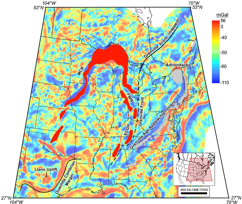
The MCR, one of the most prominent features on gravity and magnetic maps of North America, is a 3000-km-long band of buried igneous rocks extending from Lake Superior (Figure 1). These rocks outcrop from Minnesota through Wisconsin and the Upper Peninsula of Michigan. To the south the rift is deeply buried by younger sediments, but easily traced because the igneous rocks are dense and highly magnetized [Hinze et al., 1992, 1997; King and Zietz, 1971; Ojakangas et al., 2001]. Its west arm extends at least to Oklahoma, and perhaps Texas and New Mexico via similar-age diffuse volcanism [Adams and Keller, 1996]. The east arm goes through Michigan and extends southward along the Fort Wayne rift and East Continent Gravity High (ECGH) to Alabama [Keller et al., 1982].

Figure 1: Gravity map computed by upward continuing complete Bouguer anomaly (CBA) data to 40 km and subtracting result from CBA. High-gravity regions corresponding to Midcontinent Rift (MCR), Fort Wayne Rift (FWR), and East Continent Gravity High (ECGH) are shown in red. Assumed MCR geometry in Lake Superior region also shown in red. Grenville Front shown by solid line where observed and dashed lined where inferred. [Stein et al., 2014].
The rift’s enormous volume of igneous rocks makes it one of the most extensive paleorifts in the world [Hinze et al., 1992, 1997]. The volcanic rocks have been extensively studied [Davis and Green, 1997; Nicholson et al., 1997; Vervoort et al., 2007], as reviewed by Miller [2007]. However, the tectonic setting in which the MCR formed, evolved, and ceased spreading remains unclear. Our studies focus on these questions, and our initial results are summarized below.
How did it form?
In what tectonic setting the MCR formed remains unclear, despite its prominence. It formed at about 1.109-1.085 Ga within Laurentia, the core of the North American continent assembled in the Precambrian, by volcanism and normal faulting followed by subsidence and sedimentation [Cannon, 1992]. Hence it is commonly viewed as a type example of a failed rift that formed and died within a continental interior, far from its margins, not associated with a plate boundary or successful rifting/seafloor-spreading event.
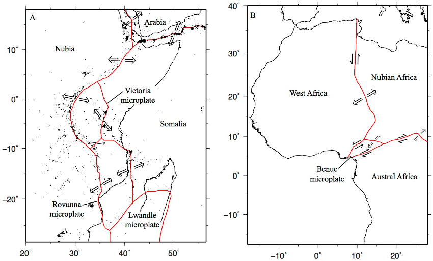
A difficulty with this view is that many intracontinental rifts are associated with plate boundary reorganizations (Figure 2). Present-day continental extension in the East African Rift (EAR) and seafloor spreading in the Red Sea and Gulf of Aden form a classic three-arm rift geometry as Africa splits into Nubia, Somalia, and Arabia. GPS and earthquake data show that the opening involves several microplates between the large Nubian and Somalian plates [Saria et al., 2013]. If the EAR does not evolve to seafloor spreading and dies, in a billion years it would appear as an isolated intracontinental failed rift similar to the MCR.

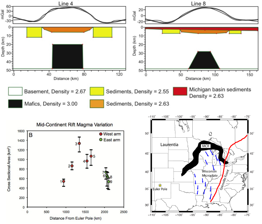
Figure 2: (Top): Two representative gravity models, one each from the east and west arms. Black dots are observed gravity; black line is calculated gravity. (Bottom left): (b) Cross-sectional magma areas in the models plotted against distance from the Chase and Gilmer [1973] Euler pole. Black bars show the range in cross-sectional areas for other modeling schemes. (Bottom right): Schematic microplate model with the Wisconsin Block rotating away from the Superior Province. This microplate model is consistent with the magma variations. [Merino et al., 2013].
Another analogy is the West Central African Rift (WCAR) system formed as part of the Mesozoic opening of the South Atlantic. Reconstructing the fit between Africa and South America without overlaps and gaps and matching magnetic anomalies requires microplate motion with up to 95 km extension within continents [Moulin et al., 2010; Seton et al., 2012]. These rifts failed about when seafloor spreading started along the whole boundary between South America and Africa, illustrating that intracontinental extension can start as part of continental breakup and end when full seafloor spreading is established.
Although similar rift systems occur earlier in the geological record, it is harder to identify them and establish their history because the plates involved are now widely separated and sometimes affected by subsequent continent-continent collisions that overrode the rifted continental margins. Also, the oceanic seafloor with its magnetic reversal record formed after the continents rifted has been subducted.
As just discussed, active rifts within continents with similar lengths to the MCR form boundaries of microplates within the evolving boundary zone between major plates. Similarly, the MCR can be described as part of a microplate’s boundary [Chase and Gilmer, 1973]. Magma volumes inferred from gravity modeling [Merino et al., 2013] are consistent with a model in which the two rift arms acted as boundaries of a microplate between them. The volume of magma along the western arm increases with distance from the Euler pole, indicating that it acted essentially as a spreading ridge, whereas the much smaller magma volumes along the eastern arm are consistent with its acting as a leaky transform (Figure 3).

Figure 3: Microplate formation during continental rifting. (a) Present rifting of Africa into three major plates and three microplates, after Saria et al. [2013]. (b) Four-microplate geometry of the West Central African rift system, formed during the Mesozoic opening of the South Atlantic, after Moulin et al. [2010]. [Stein et al., 2014].
We thus propose [Stein et al., 2014] that the MCR formed as part of the rifting of Amazonia (Precambrian northeast South America) from Laurentia (Precambrian North America) and became inactive once seafloor spreading was established (Figure 4). A cusp in Laurentia’s apparent polar wander path near the onset of MCR volcanism, recorded by the MCR's volcanic rocks, likely reflects the rifting (Figure 4). Such cusps in APW paths have been observed when continents separate and a new ocean forms between the two fragments. For example, cusps in North America’s path coincide with the rifting of Europe from North America and the rifting of Gondwana from Laurasia [Gordon et al., 1984].

Figure 4: (top) Apparent polar wander path for Laurentia, showing cusp approximately at onset of MCR volcanism (1.109 Ga) that likely reflects the rifting. MCR volcanism interval is shown in red. Poles from Elming et al. [2009] and Swanson-Hysell et al. [2009]. (bottom) Reconstruction of plate positions before Laurentia-Amazonia separation, after D’Agrella-Filho et al. [2008], Elming et al. [2009], and Tohver et al. [2002], schematic spreading center geometry, and relevant features. [Stein et al., 2014].
This scenario is consistent with the geometry and timing of Precambrian rifting events including the MCR's extension to northwest Alabama along the East Continent Gravity High, southern Appalachian rocks having Amazonian affinities [Fisher et al., 2010; Loewy et al., 2003; McLelland et al., 2010], recent interpretation of Large Igneous Provinces (LIPs) in Amazonia [Ernst et al., 2013], and paleomagnetic data showing the relative positions of Laurentia and Amazonia [D’Agrella-Filho et al. 2008; Elming et al., 2009; Tohver et al., 2002, 2006]. Hence the MCR probably connected to the extensional system that separated the two continents, and its formation and shutdown was part of the evolution of the plate boundary between Laurentia and Amazonia.
A key unresolved issue is the possible role of a mantle plume [Hutchinson et al., 1990; Nicholson et al., 1997]. Although the key feature of our scenario is the relation between the MCR and continental rifting, it neither requires nor excludes rifting being started by a plume. Although some melting occurs during passive rifting, it may be that a plume – defined loosely as some sublithospheric thermal or compositional anomaly – is required to generate the large volume of magma, ~ 1.5x10⁶ km3 [Merino et al., 2013]. Numerical modeling is now being used to explore this issue [Moucha et al., 2013].
How did it evolve?
Our best insight into the MCR’s evolution comes from seismic data. Early seismic studies indicate that the crust beneath Lake Superior and portions of the western rift arm is thickened and anomalously dense. Similar crustal thickening has been found in the eastern arm.
Seismic reflection data from the GLIMPCE program of active source studies across Lake Superior [Cannon et al., 1989; Shay and Trehu, 1993] provide a more detailed picture. Profiles show the volcanic rocks, syn-rift sediments deposited during the extension and volcanism, post-rift sediments deposited during the subsequent thermal subsidence, and sediments deposited later to the end of the Precambrian (Figure 5). Today’s basin below Lake Superior is deformed by reverse faults including the Isle Royale and Keweenaw faults. Both the volcanics and post-rift sediments dip and thicken toward the basin center, with older units dipping more steeply, indicating that they were deposited as the basin subsided. Thus the synclinal structure arose from basin subsidence rather than later compression. Volcanic underplating, producing a rift pillow, thickened the lower crust [Woelk and Hinze, 1991]. Such crustal rethickening has been identified in other rifts [Thybo and Nielsen, 2009]. Volcanism and subsidence eventually ceased, leaving the MCR as a classic example of a failed rift.

Figure 5: NW-SE cross section of Lake Superior, based on GLIMPCE profiles. BS/OG denotes Bayfield/Oronto group sediments, JS is Jacobsville Sandstone, PLV is Portage Lake Volcanics. [Witthuhn-Rolf, 1997].
The details of this sequence remain to be established. One promising source of information is the EarthScope program, which is acquiring new data about lithospheric structure below the MCR [Shen et al., 2013; Stein et al., 2011].
How did it fail?
The MCR’s “failure” - the ending of volcanism and extension and thus its failure to develop into a new ocean basin - has generally attributed to compression at about 1.060 ± 0.020 Ga during the Grenville orogeny, the assembly of Amazonia and other continents into the supercontinent of Rodinia from ~1.3 Ga - ~0.95 Ga [Cannon et al., 1993].
However, analysis of the record of compressional tectonics suggests a different view, because the earliest compression probably occurred ~25 Myr or later after the end of extension and volcanism and well into or after the post-rift subsidence phase. This view is consistent with the scenario that the MCR formed as part of the rifting of Amazonia from Laurentia and became inactive once seafloor spreading was established [Stein et al., 2014]. In this scenario, the end of the extension and rifting of the MCR was not due to a Grenville-age collision, but rather ended like many intracontinental rifts because extension was taken up elsewhere in the system. Additional information should be forthcoming from both geological and paleomagnetic [Swanson-Hysell et al., 2009; 2014] studies.
A rift and a LIP
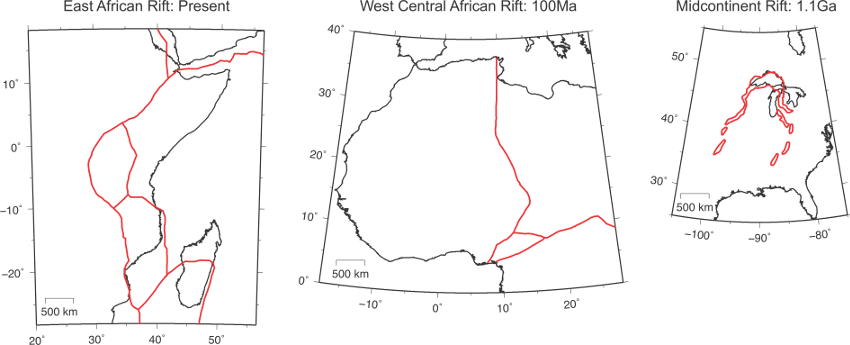
Our overall approach is to view the MCR not as an unusual feature that formed by isolated midplate volcanism and failed due to Grenville compression, but as having aspects observed in rifts and LIPs elsewhere (Figure 6). In our view, the MCR formed as part of continental rifting and became inactive once seafloor spreading was established. Comparing the MCR to other rifts [Ziegler and Cloetingh, 2004] and LIPs [http://www.largeigneousprovinces.org] is likely to yield further insights. Hence the MCR, which provides the central U.S.’s most spectacular geology and scenery, will remain an active research topic for years to come [Marshall, 2013].

Figure 6: Comparison of the East African, West Central African, and Midcontinent rift systems plotted to the same scale.
For updates on our work, see
http://www.earth.northwestern.edu/people/seth/research/mcr.html
This work was supported by NSF grants EAR-1148088 and EAR-0952345. C. Stein and S. Stein thank J. Kley and D. Hindle for hospitality at the Georg-August-Universität Göttingen, where much of the paper writing was done. S. Stein thanks the Alexander von Humboldt Foundation for supporting his stay in Germany.
References
Adams, D. C., G. R. Keller (1996), Precambrian basement geology of the Permian Basin region of West Texas and eastern New Mexico: A geophysical perspective, AAPG Bull., 80(3), 410–431.
Calais, E. et al. (2003), GPS measurements of crustal deformation in the Baikal-Mongolia area, Journal of Geophysical Research, 108, doi:10.1029/2002JB002373.
Cannon, W.F. (1992), The Midcontinent rift in the Lake Superior region with emphasis on its geodynamic evolution, Tectonophys., 213, 41-48.
Cannon, W. et al. (1989), The North American Midcontinent Rift beneath Lake Superior from GLIMPCE seismic reflection profiling, Tectonics, v. 8, p. 305-332.
Cannon, W. F., Z. E. Peterman, P. K. Sims (1993), Crustal-scale thrusting and origin of the Montreal River Monocline- a 35-km-thick cross section of the Midcontinental Rift in northern Michigan and Wisconsin, Tectonics, 12(3), 728-744.
Chase, C. G., T. H. Gilmer (1973), Precambrian plate tectonics: the Midcontinent gravity high, Earth Planet. Sci. Lett., 21, 70-78.
D’Agrella-Filho, M. S., E. Tohver, J. O. S. Santos, S.-A. Elming, R. I. F. Trindade, I. I. G. Pacca, M. C. Geraldes (2008), Direct dating of paleomagnetic result from Precambrian sediments in the Amazon craton: Evidence for Grenvillian emplacement of exotic crust in SE Appalachians of North America, Earth Planet. Sci. Lett., 267, 188–199.
Davis, D. W., J. C. Green (1997), Geochronology of the North American Midcontinent rift in western Lake Superior and implications for its geodynamic evolution, Can. J. Earth Sci., 34(4), 476-488, doi:10.1139/e17-039.
Ebinger, C., N. Sleep, (1998), Cenozoic magmatism throughout east Africa resulting from impact of a single plume, Nature, 395, 788-791.
Elming, S.-A., M. S. D’Agrella-Filho, L. M. Page, E. Tohver, R. I. F. Trindade, I. I. G. Pacca, M. C. Geraldes, W. Teixeira (2009), A palaeomagnetic and 40Ar/39Ar study of late Precambrian sills in the SW part of the Amazonian craton: Amazonia in the Rodinia reconstruction, Geophys. J. Int., 178, 106–122, doi:10.1111/j.1365-246X2009.04149.x.
Ernst, R. E., E. Pereira, M.A. Hamilton, S.A. Pisarevsky, J. Rodriques, C.C.G. Tassinari, W. Teixeira, V. Van-Dunem (2013), Mesoproterozoic intraplate magmatic “barcode” record of the Angola portion of the Congo Craton: Newly dated magmatic events at 1505 and 1110 Ma and implications for Nuna (Columbia) supercontinent reconstructions, Precam. Res., 230, 103-118, doi:10.1016/j.precamres.2013.01.010.
Fisher, C. M., S. L. Loewy, C. F. Miller, P. Berquist, W. R. Van Schumus, R. D. Hatcher Jr., J. L. Wooden, P. D. Fullagar (2010), Whole-rock Pb and Sm-Nd isotopic constraints on the growth of southeastern Laurentia during Grenvillian orogenesis, GSA Bull., 122(9–10), 1646–1659, doi:10.1130/B30116.1.
Gordon, R.G., A. Cox, S. O’Hare (1984), Paleomagnetic Euler poles and the apparent polar wander and absolute motion of North America since the Carboniferous, Tectonics, 3, 499-537.
Hinze, W. J., D.J. Allen, A.J. Fox, D. Sunwood, T. Woelk, A. Green (1992), Geophysical investigations and crustal structure of the North American Midcontinent rift system, Tectonophys., 213(1-2), 17-32, doi:10.1016/0040-1951(92)90248-5.
Hinze, W.J., Allen, D.J., Braile, L.W., Mariano, J., The Midcontinent Rift System: A major Proterozoic continental rift, in Ojakangas, R.W., Dickas, A.B., and Green, J.C., eds., Middle Proterozoic to Cambrian Rifting, Central North America, GSA Sp. Pap. 312, Boulder, Colorado, 7-34, 1997.
Hutchinson, D., R. S. White, W. F. Cannon, K. J. Schulz (1990), Keweenaw hot spot: geophysical evidence for a 1.1 Ga mantle plume beneath the Midcontinent Rift System, J. Geophys. Res., 95, 10,869-10,884.
Keller, G.R., A.E. Bland, J.K. Greenberg (1982), Evidence for a major Late Precambrian tectonic event (rifting?) in the eastern Midcontinent region, United States, Tectonics, 1, 213-223.
King, E.R., I. Zietz (1971), Aeromagnetic study of the midcontinent gravity high of central United States, Geol. Soc. Am. Bull., 82(8), 2187-2208. http://www.nature.com/news/geology-north-america-s-broken-heart-1.14281
Loewy, S. L., J. N. Connelly, I. W. D. Dalziel, C. F. Gover (2003), Eastern Laurentia in Rodinia: Constraints from whole-rock Pb and U/Pb geochronology, Tectonophysics, 375, 169–197, doi:10.1016/S0040-1951(03)00338-X.
Marshall, J. (2013), North America's broken heart, Nature 504, 24–26 (05 December 2013) doi:10.1038/504024a.
McLelland, J. M., B. W. Selleck, M. E. Bickford (2010), Review of the Proterozoic evolution of the Grenville Province, its Adirondack outlier, and the Mesoproterozoic inliers of the Appalachians, in From Rodinia to Pangea: The Lithotectonic Record of the Appalachian Region, edited by R. P. Tollo et al., vol. 206, pp. 1–29, Geol. Soc. Am. Mem., Boulder, Colo., doi:10.1130/2010.1206(02).
Merino, M., G.R. Keller, S. Stein, C. Stein (2013), Variations in Mid-Continent Rift magma volumes consistent with microplate evolution, Geophys. Res. Lett., 40, 1513-1516, doi:10.1002/grl.50295.
Miller, J. (2007), The Midcontinent Rift in the Lake Superior Region: A 1.1 Ga Large Igneous Province http://www.largeigneousprovinces.org/07nov
Moucha, R., T. Rooney, S, Stein, E. Brown (2013), Geodynamic modeling of the Mid-Continental Rift System: Is a mantle plume required? Abstract T21B-2545 presented at 2013 Fall Meeting, AGU, San Francisco, Calif., 9-13 Dec.
Moulin, M., D. Aslanian, P. Unternehr (2010), A new starting point for the South and Equatorial Atlantic Ocean, Earth-Science Rev., 98, 1-37.
Nicholson, S. W., S.B. Shirey, K.J. Schulz, J.C. Green (1997), Rift-wide correlation of 1.1 Ga midcontinent rift system basalts: Implications for multiple mantle sources during rift development, Can. J. Earth Sci., 34(4), 504-520.
Ojakangas, R.W. , G.B. Morey, J.C. Green (2001), The Mesoproterozoic Midcontinent Rift System, Lake Superior Region, USA, Sedimentary Geology 141±142, 421-442.
Saria, E., E. Calais, Z. Altamimi, P. Willis, H. Farah (2013), A new velocity field for Africa from combined GPS and DORIS space geodetic solutions: contribution to the definition of the African reference frame (AFREF), J. Geophys. Res., 118, 1677-1697, doi:10.1002/jgrb.50137.
Sengor, A., K. Burke (1978), Relative timing of rifting and volcanism and its tectonic implications, Geophysical Research Letters, 5, 419-421.
Seton, M., R.D. Muller, S. Zahirovic, C. Gaina, T. Torsvic, G. Shepard, A. Talsma, M. Gurnis, M. Turner, S. Maus, M. Chandler (2012), Global continental and ocean basin reconstructions since 200 Ma, Earth-Science Rev., 113, 212-270, doi:10.1016/j.earscirev.2012.03.002.
Shay, J., and A. Trehu (1993), Crustal structure of the central graben of the Midcontinent Rift beneath Lake Superior, Tectonophysics, 225(4), 301-335.
Shen, W., M.H. Ritzwoller, V. Schulte-Pelkum (2013), Crustal and uppermost mantle structure in the central U.S. encompassing the Midcontinent Rift, J. Geophys. Res., 118, 4325-4344, doi:10.1002/jgrb.50321.
Stein, C. A., S. Stein, M. Merino, G. Randy Keller, L. M. Flesch, and D. M. Jurdy (2014), Was the Mid-Continent Rift part of a successful seafloor-spreading episode?, Geophys. Res. Lett., 41(5), 1465-1470, doi:10.1002/2013GL059176, 2014.
Stein, S., S. van der Lee, D. Jurdy, C. Stein, D. Wiens, M. Wysession, J. Revenaugh, A. Frederiksen, F. Darbyshire, T. Bollmann, J. Lodewyk, E. Wolin, M. Merino, and K. Tekverk (2011), Learning from failure: the SPREE Mid-Continent Rift Experiment, GSA Today, 21(9), 5-7, doi:10.1130/G120A.1.
Swanson-Hysell, N.L., A.C. Maloof, B.P. Weiss, D.A.D. Evans (2009), No asymmetry in geomagnetic reversals recorded by 1.1-billion-year-old Keweenawan basalts, Nature Geoscience, 2, 713-717, doi:10.1038/NGEO622.
Swanson-Hysell, N.L., S. Burgess, A.C. Maloof, S. Bowring (2014), Magmatic activity and plate motion during the latent stage of Midcontinent Rift development, Geology, in press.
Thybo, H., H. Nielson (2009), Magma-compensated crustal thinning in continental rift zones, Nature, 457, 873-876.
Tohver, E., B.A. van der Pluijm, R. van der Voo, G. Rizzotto, J.E. Scandolara (2002), Paleogeography of the Amazon craton at 1.2 Ga: Early Grenvillian collision with the Llano segment of Laurentia, Earth Planet. Sci. Lett., 199, 185-200.
Tohver, E., W. Teixeira, B. A. van der Pluijm, M. C. Geraldes, J. S. Bettencourt, and G. Rizzotto (2006), Restored transect across the exhumed Grenville orogen of Laurentia and Amazonia, with implications for crustal architecture, Geology, 34(8), 669–672, doi:10.1130/G22534.1.
Vervoort, J. D., K. Wirth, B. Kennedy, T. Sandland, and K. S. Happ (2007), The magmatic evolution of the Midcontinent rift: New geochronologic and geochemical evidence from felsic magmatism, Precambrian Res., 157(1-4), 235-268, doi:10.1016/j.precamres.2007.02.019.
Whitmeyer, S., K. Karlstrom (2007) Tectonic model for the Proterozoic growth of North America, Geosphere, 3, 220-259.
Witthuhn-Rolf, K.M. (1997) A structural analysis of the Midcontinent Rift in Michigan and Minnesota, 97-113, in Ojakangas, R.W., Dickas, A.B., Green, J.C, eds, Middle Proterozoic to Cambrian Rifting, Central North America, GSA Spec. Paper 312, 97-113.
Woelk, T.S., W.J. Hinze (1991) Model of the midcontinent rift system in northeastern Kansas, Geology, 19, 277-280.
Ziegler, P., S. Cloetingh (2004), Dynamic processes controlling evolution of rift basins, Earth Science Reviews, 64, 1-50.
