November 2013 LIP of the month
Greater Exmouth LIP (NW Australia)
Max Rohrman
Murphy Oil Corporation, 9805 Katy Fwy Suite G200, Houston, TX77057, USA
Email: max.rohrman@hotmail.com
INTRODUCTION
The Greater Exmouth LIP (Figure 1) is a ~ 400 x 400 km subsea region off the NW Australian coast, consisting of several sedimentary basins and rifted continental fragments that suffered a major magmatic event in the Late Jurassic – Early Cretaceous (Symonds et al., 1998), associated with continental breakup (Mihut and Müller, 1998; Longley et al., 2002). Although the region has traditionally been identified as a volcanic margin Large Igneous Province (LIP), its temporal and spatial extent is poorly defined (e.g. White and McKenzie, 1989; Coffin and Eldholm, 1994). In contrast with most large igneous provinces (LIPs), the Exmouth LIP is characterized by major intrusive activity and relatively minor extrusives (Figure 1) as observed on reflection seismic data (Symonds et al., 1998; Rey et al., 2008; Rohrman, 2013), augmented by a few ODP and exploration wells as well as potential field data (Sayers et al., 2002; Stagg et al., 2004). However, this relative lack of volcanic activity makes the Exmouth LIP an excellent place to study processes generating LIPs, offering detailed imaging of crustal scale magmatic features (Figure 2). Current research on continental LIPs rely almost entirely on outcrop data, while submerged oceanic plateaus and many volcanic margins suffer from poor seismic imaging owing to the detrimental effect of shallow basalt flows on sub-basalt seismic imaging (e.g. Rohrman, 2007).
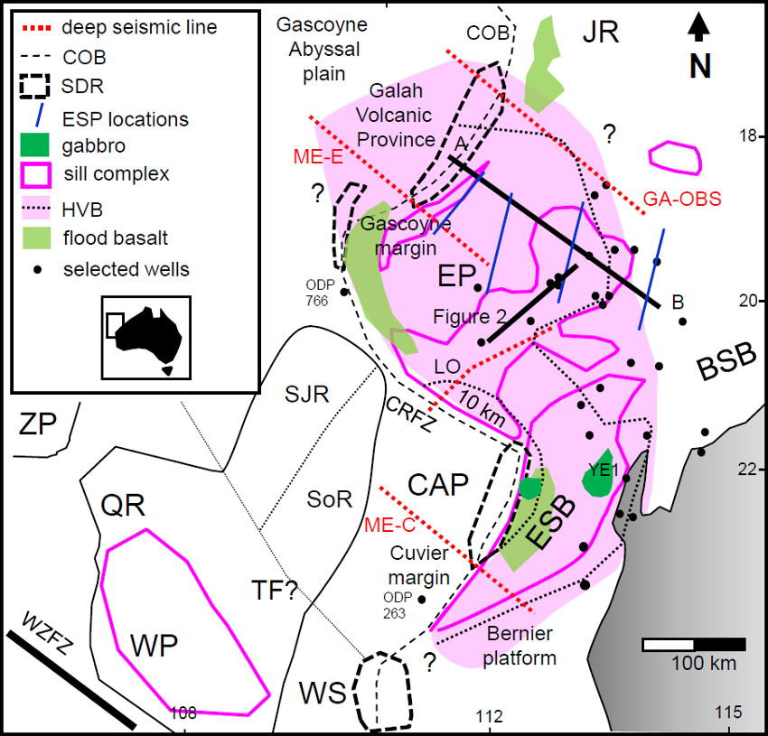
Figure 1: Overview Map of Greater Exmouth LIP. For explanation see text. Stippled line labeled TF is potential lineament or transform. Other abbreviations: CAP Cuvier Abyssal Plain; ZP Zenith Plateau; COB Continent Ocean Boundary; SDR Seeward Dipping Reflectors. ESP Expanded Spread Profile. LO Lorenzo et al (1991) seismic profile.
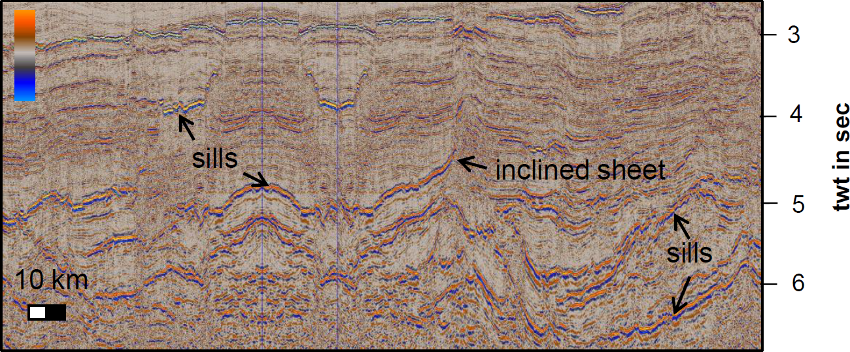
Figure 2: Sill complexes intruding Triassic Mungaroo Formation on the Exmouth Plateau. See Figure 1 for location.
GEOLOGICAL SETTING
The Exmouth LIP consists of the Exmouth Plateau (EP), a prolific gas-prone sedimentary basin, characterized by ~ 7 km thick Triassic Mungaroo Formation (Figure 3), thin Jurassic sediments and a ~ 2 km thick post rift sequence consisting of Cretaceous and Tertiary sediments.
Figure 3: Simplified stratigraphic column and events chart for the Exmouth region
Triassic deltaic sediments are faulted at a high angle as a result of Early to Mid Jurassic extension, with most extension taking place in the lower crust, generating an asymmetric crustal configuration (Driscoll and Karner, 1998). Very little sedimentation took place on the EP during the Jurassic, with most sediments derived from eroding Triassic tilted fault blocks that were close to sea level in the Early to Mid Jurassic.
In contrast, the en-enchelon Exmouth Sub Basin (ESB) and Barrow Sub Basin (BSB), record major extension in the Early and Mid Jurassic, accommodating a several km thick sequence of Jurassic sediments (Figure 1,3).
Deposition of the Berriasian-Valanginian Lower Barrow Group delta was contemporaneous with major intrusive activity on the EP and ESB, evidenced by sills and dykes intruding Triassic and Jurassic sediments on the EP and ESB respectively. Magmatism and Lower Barrow Group deposition was accompanied by large scale erosion along the Cape Range Fault Zone (CRFZ) and southern ESB (Lorenzo et al., 1991; Müller et al., 2002). These events were followed by continental breakup commencing in the mid Valanginian and a global lowstand event generating a major unconformity in the ESB and BSB. Subsequently, redeposition of the Barrow delta, generated the post breakup Birdrong sandstone formation and initiation of a thermal sag phase affecting the whole region. Finally, the EP was affected by a major Campanian inversion event, followed by regional Neogene compression as a result of plate reorganization, generating, among other features, the Exmouth Peninsula arch (Longley et al., 2002).
2. MAGMATISM
Intrusive activity is widespread on the EP and ESB as observed on multiple vintage 2D and 3D seismic reflection data, mainly provided by the hydrocarbon industry. On seismic data igneous sills are recognized due to their sub horizontal nature and high acoustic impedance, resulting in bright amplitudes on seismic sections (Figure 2). Moreover, they tend to be oval or sub-circularly shaped, of limited extend and often crosscut sedimentary rocks at a low angle (Planke et al., 2005). Dykes on the other hand, are poorly imaged on seismic data owing to their sub-vertical nature. They are visible on 3D seismic when their thickness exceeds the horizontal seismic resolution and when they occur at an angle, essentially representing an inclined sheet (Figure 2). The EP is well known for its spectacular sill complexes imaged on seismic reflection data between 4 and 11 km depth (Figure 4) (Symonds et al., 1998, Frey et al., 1998, Rohrman, 2013). However, age control on the intrusives is relatively poor, since intrusions rarely intersect exploration wells. Stratigraphic relationships derived from seismic data, suggest a Tithonian to lower Valanginian age (Symonds et al., 1998; Rohrman, 2013). The Yardie East – 1 well (YE1, Figure 1) on the Exmouth peninsula records several thin sills or dykes intruding Middle Jurassic and older sediments (Müller et al., 2002) and ODP 766 contains dolerite intrusions in lower Cretaceous sediments (Sayers et al., 2002), consistent with seismic interpretations. The EP is underlain by an extensive High Velocity Body (HVB) at the base of the crust derived from wide angle ESP (Expanded Spread Profile) (e.g. Mutter et al., 1988; Lorenzo et al 1991) (Figure 4). The HVB displays bright horizontal reflections suggesting that it consists of sills, with the impedance contrast possibly indicating higher velocity/density ultramafic cumulates interfingering with lower velocity/density gabbro (Cox, 1980). The total thickness of the HVB unit, derived from seismic, gravity and magnetic data (Mutter et al., 1989; Lorenzo et al., 1991; Frey et al., 1998; Goncharov et al., 2006), is estimated between 10 km near the Cape Range Fault zone (CRFZ) to 3.5 km in the Central Exmouth Plateau (Figure 1) thinning to the NW and SE (Lorenzo et al., 1991; Mutter et al., 1988; Frey et al., 1998; Fomin et al., 2000; Direen et al., 2008). Refraction velocities of 7 -7.4 km/s suggest that the HVB consists of mafic or ultramafic magma chamber(s) (White and McKenzie, 1989; Coffin and Eldholm, 1994; Ridley and Richards, 2010). The HVB magma chamber, is most likely the source of the sill complexes, based on magmatic overpressure calculations (Rohrman, 2013).
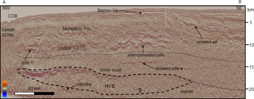
Figure 4: AB depth cross-section on the Exmouth Plateau (for location see Figure 1), showing crustal configuration and relationship with HVB and sill complexes
Volcanic activity is also recorded on the Cuvier Margin, where SDRS and landward flows (Planke et al., 2000) are interpreted, with similar features depicted along the Gascoyne margin (Mihut and Müller, 1998; Rey et al., 2008) (Figure 1). The oceanic crust off the Gascoyne margin, known as the Galah volcanic province (Rey et al., 2008) (Figure 1) is characterized by volcanic protrusions and a thickened crust and a high velocity body (HVB) on deep seismic profiles ME-E and GA-OBS (Figure 1) (Rey et al., 2008; Fomin et al., 2000; Goncharov et al., 2006), although the thickened oceanic crust has also been interpreted as thinned continental crust (Direen et al., 2008).
The Wallaby Plateau (Figure 1) is a continental fragment rifted away from the Cuvier margin during breakup (Sayers et al., 2002). Although very little is known about the geology, sparse 2D seismic lines indicate a NE-SW rift system, paralleling the Cuvier margin, Seaward Dipping Reflector Series (SDRS) in the Wallaby Saddle (WS) as well as evidence for sill like intrusions, intruding potential Triassic sediments (Symonds et al., 1998). Recent dredgings found Oxfordian/Kimmeridgian micropaleontology (Quilty, 2011), confirming the sedimentary nature of the observed seismic reflectors. A pronounced high known as the Quokka Rise (QR) is located to the north of the WP (Figure 1) and is presumed to originate from igneous activity (Sayers et al., 2002). Recent plate reconstructions place the Wallaby Plateau and its Sonne (SoR) and Sonja Ridge (SJR) extensions (Figure 1), at the Cuvier margin before breakup (Gibbons et al., 2012), although the Sonne and Sonja ridges have also been interpreted as oceanic crust (Robb et al., 2005).
The ESB records similar intrusions as observed on the EP, consisting of sills and dykes (Symonds et al., 1998). However, this region also contains large gabbroic intrusions, interpreted from gravity and magnetic data (Müller et al., 2002) (Figure 1). While there is seismic and magnetic/gravity evidence for a HVB below the EP, there is little information for a HVB below the ESB. Magmatic activity seems more profound in the region where the gabbro bodies are located (Figure 1), diminishing in intensity toward the Bernier Platform in the south. The Bernier Platform (BP) is characterized by Paleozoic rocks below the Valanginian unconformity. Seismically the BP Paleozoic rocks appear transparent with minor intrusives imaged on 2D seismic. A deep seismic line (ME-C; Figure 1) records evidence for a partly highly reflective crust (Sugimoto et al., 2002), characteristic for igneous material. The BP and WP are separated by the WS in the southern region (Figure 1) where SDRS have been observed on seismic data (Symonds et al., 1998; Mihut and Müller, 1998). Other notable volcanic features include the Joey Rise (JR) (Gibbons et al., 2012) and an isolated sill complex in the north of Figure 1.
MODELS FOR MAGMATISM
Various models have been proposed for the Greater Exmouth region, that fall into two distinct categories. The first follows White and McKenzie’s (1989) hypothesis, suggesting a rifting origin induced by a thermal anomaly or mantle plume. This model was further developed by Mihut and Müller (1998) and Müller et al (2002) who proposed an initial hotspot location on the Bernier Platform, near the WS, propagating NW-SE along the Wallaby-Zenith Fault Zone (WZFZ), incorporating the Wallaby and Zenith Plateaus. Recently, Rohrman (2013) suggested that that the spatial distribution of intrusives and HVB, coupled by the deposition of the Barrow delta in the Early Cretaceous would favor a thermal anomaly or upwelling/mantle plume model. The second model advocated by Mutter et al. (1988), Lorenzo et al., (1991), Hopper (1992) as well as Müller et al (2002) preferred a decompression melting model supplemented by small scale convection generated by the hot Cuvier spreading ridge moving along the cold Cape Range Fault Zone (CRFZ) transform margin. It seems problematic to generate enough magmatism in this latter model, but more importantly, the spatial distribution of the intrusives and HVB observed on the EP, ESB and WP is not easily explained by small scale convection and juxtaposition of a hot spreading ridge. Moreover, magmatism seems older than Cuvier margin ocean spreading (Gibbons et al., 2012; Rohrman, 2013) (Figure 3). The mantle plume model, on the other hand fails to demonstrate a convincing hotspot track (Hopper et al., 1992; Müller et al., 2002). Furthermore, it is now known that the Wallaby Plateau consists mainly of continental crust (Sayers et al., 2002) and not purely igneous crust as suggested earlier in the mantle plume model (Mihut and Müller, 1998), making the proposed hotspot track doubtful. Thus, to date, no convincing model exists for the Exmouth Region, except for it being defined as a volcanic margin (e.g. Coffin and Eldholm, 1994).
Disclaimer – The ideas and interpretations expressed here are the author’s and not those of Murphy Oil.
REFERENCES CITED
Coffin, M.F., and Eldholm, O., 1994, Large igneous provinces: crustal structure, dimensions, and external consequences: Reviews of Geophysics v. 32, p. 1-36.
Cox, K.G., 1980, A model for flood basalt volcanism: Journal of Petrology v. 21, p. 629-650.
Direen, N.G., H.M.J. Stagg, P.A. Symonds and J.B. Colwell (2008) Architecture of volcanic rifted margins: New insights from the Exmouth-Gascoyne margin, Western Australia, Aust. J. Earth Sci. 55, 341-363, doi:10.1080/08120090701769472
Driscoll, N.W., and Karner, G.D., 1998, Lower crustal extension across the northern Carnarvon basin, Australia: evidence for an eastward dipping detachment: Journal of Geophysical Research v. 103, p. 4975–4991.
Fomin, T., A. Goncharev, P. Symonds and C. Collins (2000) Acoustic structure and seismic velocities in the Carnarvon Basin, Australian North West Shelf: towards an integrated study, Expl. Geophys. 31, 579-583
Frey, Ø., Planke, S., Symonds, P.A., and Heeremans, M., 1998, Deep crustal structure and rheology of the Gascoyne volcanic margin, Western Australia: Marine Geophysical Research v. 20, p. 293–312.
Gibbons, A.D., U. Barckhausen, P. van den Bogaard, K. Hoernle, R. Werner, J.M. Whittaker and R.D. Müller (2012), Constraining the Jurassic extent of Greater India: Tectonic evolution of the West Australian margin, Geochem., Geophys., Geosyst. 13, doi:10.1029/2011GC003919
Goncharov, A, Deighton, I, Duffy, L., McLaren, S., Tischer, M. and Heine, M. (2006) Basement and crustal controls on hydrocarbons maturation on the Exmouth Plateau, North West Australian margin, Poster AAPG ICE, Perth.
Hopper, J.R., Mutter, J.C., Larson, R.L., Mutter, C.Z., and Northwest Australia study group, 1992, Magmatism and rift margin evolution: Evidence from Northwest Australia: Geology v. 20, p. 853–857.
Longley, I.M., Buessenshuett, C., Clydsdale, L., Cubitt, C.J., Davis, R.C., Johnson, M.K., Marshall, N,M., Murray, A.P., Somerville, R., Spry, T.B., and Thompson, N.B., 2002, The North West Shelf of Australia – a Woodside perspective, in Keep, M., and Moss, S.J., eds., The sedimentary basins of Western Australia 3. Proceedings of Petroleum Exploration Society of Australia Symposium, Perth, p. 27–88
Lorenzo, J.M, Mutter, J.C., Larson, R.L., & Northwest Australia study group, 1991, Development of the continent-ocean transform boundary of the southern Exmouth Plateau: Geology v. 19, p. 843-846
Mihut, D. and R.D. Müller (1998) Volcanic margin formation and Mesozoic rift propagators in the Cuvier abysal plain off western Australia, J Geophys. Res. 103, 27135-27149.
Müller, R.D., Mihut, D., Heine, C., O’Neill, C. and Russell, I. 2002, Tectonic and volcanic history of the Carnarvon Terrace: Constraints from seismic interpretation and geodynamic modelling in Keep, M., and Moss, S.J., eds., The sedimentary basins of Western Australia 3. Proceedings of Petroleum Exploration Society of Australia Symposium, Perth, p. 719–738
Mutter, J.C., Larson, R.L., and Northwest Australia Study Group, 1989, Extension of the Exmouth Plateau, offshore northwestern Australia: Deep seismic reflection/refraction evidence for simple and pure shear mechanisms: Geology v. 17, p. 15–18.
Planke, S. T. Rassmussen, S.S. Rey, and R. Myklebust (2005) Seismic characteristics and distribution of volcanic intrusions and hydrothermal vent complexes in the Vøring and Møre basins. in Petroleum Geology: North-West Europe and global perspectives – Proceedings of the 6th petroleum geology conference, edited by A.G. Doré and B.A. Vining, pp 833-844 Geological Society, London.
Quilty, P. (2011) Late Jurassic foraminifera, Wallaby Plateau offshore Western Australia: Journal of Foraminiferal Research 41, 182-195 doi:10.2113/gs/fr.41.2.182
Rey, S.S., Planke, S., Symonds, P.A., and Faleide, J.I, 2008, Seismic volcanostratigraphy of the Gascoyne margin, Western Australia: Journal of Volcanology and Geothermal Research v. 172, p. 112–131, doi:10.1016/j.jvolgeores.2006.11.013.
Ridley, V.A. and M. Richards, (2010), Deep crustal structure beneath large igneous provinces and petrologic evolution of flood basalts, Geochem., Geophys., Geosyst. 11, doi:10.1029/2009GC002935
Robb, M.S., B. Taylor and A.M. Goodliffe (2005) Re-examination of the magnetic lineations of the Gascoyne and Cuvier abyssal plains, off NW Australia, Geophys. J. Int. 163, 42-55
Rohrman, M. (2007) Prospectivity of volcanic basins: trap delineation and acreage de-risking, AAPG Bull. 91, 915-939, doi:10.1306/12150606017.
Rohrman, M. (2013) Intrusive large igneous provinces below sedimentary basins: an example from the Exmouth plateau (NW Australia), Journal of Geophysical Research Solid Earth. 118, 915-939, doi:10.1002/jgrb50298.
Sayers, J., I. Borissova, D. Ramsay and P.A. Symonds (2002) Geological framework of the Wallaby Plateau and adjacent areas, Geoscience Australia Record 2002/21, 113p.
Stagg, H.M.J, Acock, M.B., Bernardel, G., Moore, A.M.G., Symonds, P.A. and Exon, N.F. (2004) Geological framework of the outer Exmouth Plateau and adjacent ocean basins, Geoscience Australia Record 2004/13,
Sugimoto, M., Goodliffe, A.M., Taylor, B., Driscoll, N., Sutherland, F., Karner, G.D., Tischer, M., Diebold, J., ten Brink, U and Ryan, D. (2002) New seismic reflection images from the continent-ocean transition across the Exmouth and Cuvier margins, off Northwestern Australia, Abstract T52C-1222 AGU Fall Meeting
Symonds, J., Planke, S., Frey, Ø., and Skogseid, J., 1998, Volcanic evolution of the Western Australian continental margin and its implications for basin development, in Purcell, P.G., and Purcell, R.R., eds., The sedimentary basins of Western Australia 2. Proceedings of Petroleum Exploration Society of Australia Symposium, Perth, p. 33–54.
White, R., and McKenzie, D., 1989, Magmatism at Rift zones: The generation of continental flood basalts at rift margins: Journal of Geophysical Research v. 94, p. 7685–7729.