October 2004 LIP of the Month
Corresponds to event #37 in LIP record database.
The Emeishan large igneous province: Integrated geologic, geophysical and geochemical evidence for a fossil mantle plume
Yi-Gang Xu, Bin He
Guangzhou Institute of Geochemistry,
Chinese Academy of Sciences,
510640 Guangzhou, China
yigangxu@yahoo.com
Sun-Lin Chung
Department of Geosciences,
National Taiwan University,
Taipei 10699, Taiwan
27 September 2004
Partly based on a paper published in the October 2004 issue of Geology: Xu Y.-G., He B., Chung S.L., Menzies M.A., and Frey F.A., 2004. The geologic, geochemical and geophysical consequences of plume involvement in the Emeishan flood basalt province. Geology 30: 917-920. download here (1 Mb)
Introduction
The Emeishan large igneous province (LIP) is located in the western margin of the Yangtze Craton, SW China (Fig. 1). It is exposed in a rhombic province of 250 000 km2 within Yunnan, Sichuan and Guizhou Provinces (Fig. 1). The Longmenshan thrust fault and the Ailao Shan-Red River strike-slip fault are generally considered as its northwestern and southwestern boundaries, respectively. However, some basalts and mafic complexes exposed in the Simao basin, northern Vietnam and Qiangtang terrain, are possibly an extension of the Emeishan LIP (Chung et al., 1998; Xiao et al., 2003; Hanski et al., 2004). Some Emeishan-type basalts traced in southwest Yunnan and northern Vietnam may be related to the mid-Tertiary continental extrusion of Indochina relative to South China along the Ailao Shan-Red River fault zone (Chung et al., 1997). It is likely that the later tectonic events have resulted in major disruption of the former igneous province. The thickness of the entire volcanic sequence in this LIP varies considerably from over 5000 meters in the west to a few hundred meters in the east. The province consists of dominant basaltic lavas and subordinate pyroclastic rocks. In the western sub-province, flows and tuff of trachytic and rhyolitic composition form an important member in the uppermost sequence (Chung et al., 1998; Xu et al., 2001). Such a compositional bimodality is also revealed by the associated intrusive rocks that comprise syneites and layered gabbros. Some of syneites and gabbros are associated with massive V-Ti-Fe ore deposits.
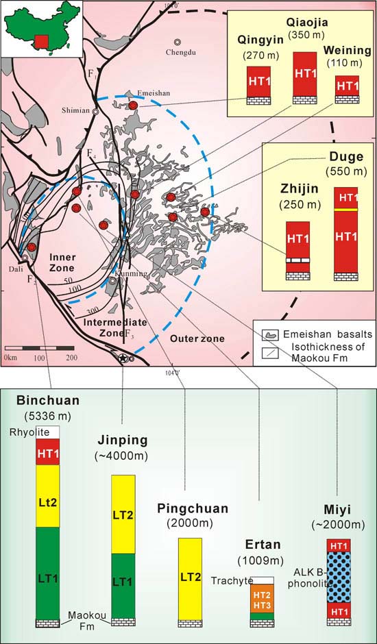
Figure 1: Distribution of Late Permian Emeishan basalts in SW China and stratigraphic variation of 10 representative lava successions. Also shown are isopachs of Maokou Formation that delineate a subcircular domal structure formed prior to Emeishan volcanism (He et al., 2003). Dashed curves separate inner, intermediate, and outer zones of dome, which are characterized by varying extent of erosion of Maokou limestone. HT—high-Ti basalt; LT—low-Ti basalt; ALK—alkaline series. Classification of LT1, LT2, HT1, HT2 and HT3 and data are after Xiao et al. (2003) and Xu et al. (2001, 2003).
The currently available dynamic interpretation for the generation of the Emeishan basalts mainly includes (a) a rift-based model and (b) a mantle plume initiation model. The rift model does not require a mantle plume to explain the genesis of the Emeishan basalts. The western Yangtze Craton was a passive continental margin during the late Permian period. It is suggested that the Emeishan basalts were erupted as a result of lithospheric extension induced by the subduction of the Palaeo-Tethyan oceanic plate underneath the Changdu micro-continent (Luo et al., 1990; Dmitriev and Bogaikov, 1996). The “Panxi rift” (Tan, 1987) was the center of the Emeishan LIP. Since the middle of 1990’s, the mantle plume model has been increasingly adopted to understand the genesis of the Emeishan basalts. However, this model was not rigorsly evaluated until recently (He et al. 2003; Xu et al., 2004).
Click to see larger image.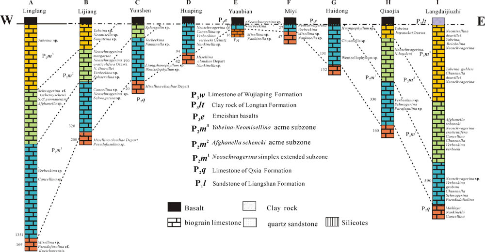
Figure 2: West-east orientated biostratigraphic correlation of the Maokou Formation in the Emeishan LIP.
A rapid, km-scale lithospheric uplift prior to the Emeishan volcanism
To characterize the crustal processes prior to the Emeishan volcanism, He et al., (2003) described the nature of the strata underneath the basalts (i.e., the Maokou Formation). Correlation and comparison of the biostratigraphy of the Maokou Formation reveal a systematic thinning of the strata beneath the Emeishan basalts; thinned carbonates are capped by a subaerial unconformity (Fig. 2), which in many cases is evident as karst paleotopography, zones of paleoweathering, and local and basal conglomerates. Provenance analysis of the clasts in the conglomerates indicates derivation from the uppermost Maokou Formation. Therefore, the stratigraphic thinning likely resulted from differential erosion due to regional uplift. Isopachs of the Maokou Formation further delineate an uplifted area with a roughly circular shape (Fig. 1), very similar to the crustal doming above an upwelling mantle plume predicted by theoretical modeling (Campbell and Griffiths, 1990). Combining the extent of eroded Maokou limestone with erosion rates of 0.12-0.3 mm/year (He et al., 2003) allows us to estimate the amount of uplift necessary to produce these relationships. The duration of the kilometer-scale uplift is estimated to be <3 m.y. and its radius >700 km (He et al., 2003). The extent of uplift is >1000 m in the core of the uplifted region. So far, there is no known process on Earth, other than mantle plumes, that can form lithospheric domes 1000 km or more in radius and >1 km high within several million years.
The domal structure associated with the Emeishan large igneous province can be divided into inner, intermediate, and outer zones (Fig. 1) in terms of the extent of erosion of the Maokou Formation. Such a division of the domal structure is important because it provides a natural basis to subdivide the Emeishan large igneous province. Accordingly, the apex of the domed area may correspond to the plume head and the margins the plume peripheries.
Spatial variation in the basalt geochemistry
In order to investigate compositional variations in the lavas from the center to the margin of the dome, the volcano-stratigraphy at 10 locations in the inner and intermediate zones has been sampled, and >350 samples were analyzed for major and trace element compositions (Xu et al., 2001, 2003; Xiao et al., 2003). The Jinping section was initially within the inner zone and was displaced to its present position by Cenozoic sinistral movement along the Red River fault (Xiao et al., 2003). Data compilation reveals a systematic change in basalt type from the inner to intermediate zones (Fig. 1). In general, the domed region of the Emeishan large igneous province comprises thick (2000–5000 m) sequences of dominant low-Ti volcanic rocks and subordinate picrites (Chung and Jahn, 1995), high-Ti and alkaline lavas (Xu et al., 2001, 2003; Xiao et al., 2003). In contrast, thin sequences (<500 m) of high-Ti volcanic rocks mainly occur on the periphery of the domal structure (rock classification is after Xu et al. [2001]). Xu et al. (2001) have shown that the high-Ti and low-Ti lavas require very different mantle conditions that are consistent with temperature variation across a plume head (Campbell and Griffiths, 1990). Application of rare earth element inversion techniques (McKenzie and O’Nions, 1991) reveals that the low-Ti lavas originated at 60–140 km depth and required 16% melting and mantle temperatures of >1500 °C. In contrast, the high-Ti lavas were generated at 75–100 km depth during events of much smaller degrees of melting (1.5%) and at lower mantle temperatures (<1500 °C). Therefore, the transition from the low-Ti to high-Ti lavas, which is associated with a change in thickness of the volcanic rocks (suggestive of different melt-production rates), was likely accompanied by a decreasing thermal gradient. The predominance of the thick low-Ti lavas in the inner zone (Fig. 1) suggests that the mantle beneath the core of the domal structure underwent a larger extent of partial melting than that under the marginal area. This suggestion and the occurrence of picrites in the inner zone are consistent with a hotter mantle beneath the dome center than beneath the dome periphery. A likely scenario is that a plume head was present underneath the inner zone.
There are additional observations adding complexity to this simple thermal-zonation model. Specifically, within the inner zone sections, high-Ti (HT1 and HT2-HT3) lavas occur in the uppermost parts of the Binchuan and Ertan sections, respectively, and a thick sequence of evolved alkaline lava (hawaiite to phonolite) occurs between high-Ti lavas in the Miyi section (Fig. 1). Possibly, these high-Ti and alkaline lavas are relatively young compared to low-Ti lavas and reflect the waning of plume-related volcanism (Xu et al., 2001). However, to date we have no age constraints on lavas in these three sections. Nevertheless, low-Ti, HT2-HT3, and alkaline lavas occur exclusively in the inner zone, and they were subject to significant crustal contamination (Xu et al., 2001, 2003). These factors may be related to a larger degree of thermal remobilization of the lithosphere above the plume head compared to that above the plume periphery.
Crustal thickness
In relation to the domal structure outlined earlier, there is a gradual decrease in crustal thickness from the center to the margin of the dome (Fig. 3). The crustal thickness in the inner zone ranges from 55 to 64 km (av. 61.5 km), which is considerably thicker than that beneath eastern China (<35 km), a typical non-rifted continental margin. The crust in the intermediate zone is also relatively thick, ranging from 38 to 54 km (average, 45 km), but is thinner than in the inner zone. The data in the outer zone are sparse but define a range of 35–43 km (Fig. 3). Seismic tomographic modeling further reveals that the lower crust in the inner zone has a high seismic P-wave velocity ranging from 7.1 to 7.8 km/s (Liu et al., 2001). The thickness of this high-velocity lower crust is as much as 25 km (average, 20 km). On the other hand, the crust outside of the inner zone is relatively thin (<45 km) and the high-velocity layer is generally absent. Different crustal structures are therefore suggested for the inner and intermediate zones of the domed area. It is interesting to note that the outline of the high-velocity lower crust according to seismic data coincides with the domal structure defined on the basis of sedimentary rocks.
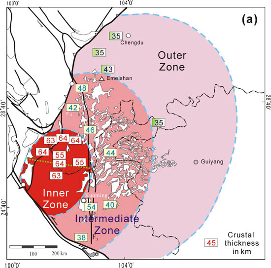
Figure 3: Crustal thickness data plotted over domal area of Emeishan large igneous province. Data sources: Zhang et al. (1988); Yuan (1995); Liu et al. (2001).
A genetic link between the crust-mantle structure and a mantle plume is thus inferred. The thicker crust in the inner zone reflects high melt production resulting from the higher temperature in the central part of the plume and uplift of lithosphere above the plume head that triggered relatively high amounts of decompression melting (Fig. 4). Also high melt production may lead to cooling and fractionation of melts at the crust-mantle boundary, thereby creating cumulate rocks that form the high-velocity lower crust (Farnetani et al., 1996).
A fossil mantle plume in the Emeishan LIP
While a heated debate rages around the existence, or otherwise, of mantle plumes (DePaolo and Manga, 2003; Foulger and Natland, 2003), this study provides compelling evidence for the existence of a fossil mantle plume beneath the Emeishan flood basalt province of southwest China. Sedimentologic and paleogeographic data show unequivocal evidence for a lithospheric doming event prior to the Emeishan volcanism. In turn this analysis provides a unique framework within which to interpret data from many disciplines. Systematic geochemical and geophysical variations and geologic observations in and around the Emeishan large igneous province are best explained in terms of plume involvement in flood volcanism (Fig. 4; Xu et al., 2004).
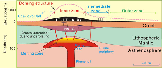
Figure 4: Cartoon illustrating surface uplift, generation of Emeishan basalts, and crustal accretion in the context of the upwelling of a mantle plume. HVLC—high velocity lower crust; HT—high-Ti basalt; LT—low-Ti basalt; ALK—alkaline series.
Age and implications
An accurate determination of the age and duration of the Emeishan basalts is hindered because they have been pervasively affected by a low to intermediate temperature metamorphism (Boven et al. 2002; Ali et al., 2004). Lo et al. (2002) presented the first set of high-precision 40Ar/39Ar plateau ages of volcanic and intrusive rocks from the Emeishan Traps. The results define a main stage of the flood magmatism at ~251–253 Ma and subordinate precursory activity at ~255 Ma. This time span is generally coeval with, or slightly older than, the age of the P–Tr boundary estimated by the ash beds in the Meishan stratotype section and the main eruption of the Siberian Traps. However, using the SHRIMP to analyze zircons, Zhou et al. (2002) have established the age of the Xinjie intrusion in the Emeishan igneous province, believed to be 259±3 Ma. These authors therefore argued for a temporal link between the Emeishan large igneous province and the end-Guadalupian mass extinction (Courtillot and Renne, 2003).
Stratigraphic relationship between the Emeishan basalts and Permian sedimentary rocks provides some constraints on the age of eruption of the Emeishan basalts. The Permian strata in south China may be divided, in ascending order, into Liangshan (Lower Permian), and Qixia and Maokou (Middle Permian), and Wujiaping and Changxing (Upper Permian) Formations. The Emeishan basalts cover the Middle Permian Maokou Formation and are capped by the uppermost Permian Xianwei Formation and Longtan Formation (equivalent to the Wujiaping Formation) in the eastern part of the province and by Triassic sediments in the central part. As discussed previously, the western and central sub-provinces may be the plume impact site. Consequently, the absence of the late Permian sequence in this area may be related to the uplifted topography compared to that in the western sub-province. We therefore suggest that the Emeishan basalts were erupted prior to the P-Tr boundary. The boundary between the middle Permian and late Permian corresponds to the Capitanian/Kazanian stage (Harland et al., 1990). Therefore, the eruption age of the overlying magmas should be between 254-258 Ma. Further study is clearly needed to determine the age of the Emeishan volcanic emission accurately, and to test the validity of the assumed short duration of the eruption.
References
Ali J.R., Lo C.H., Thompson G.M., and Song X.Y., 2004. Emeishan Basalt Ar-Ar overprint ages define several tectonic events that affected the western Yangtze Platform in the Mesozoic and Cenozoic, Journal of Asian Earth Sciences, 23 (2): 163-178.
Boven, A., Pasteels, P. Punsalan, L.E., Liu, J., Luo, X., Zhang, W., Guo, Z., and Hertogen, J., 2002. Ar/Ar geochronological constraints on the age and evolution of the Permo-Triassic Emeishan volcanic province, southwest China, J. Asain Earth Sci. 20: 157-175.
Campbell, I.H., and Griffiths, R.W., 1990, Implications of mantle plume structure for the evolution of flood basalts: Earth and Planetary Science Letters, 99:. 79–93.
Chung, S.L., and Jahn, B.M., 1995. Plume-lithosphere interaction in generation of the Emeishan flood basalts at the Permian-Triassic boundary. Geology, 23: 889-892.
Chung, S.L., Jahn, B.M., Wu, G.Y., Lo, C.H., and Cong, B.L., 1998. The Emeishan flood basalt in SW China: a mantle plume initiation model and its connection with continental break-up and mass extinction at the Permian-Triassic boundary. In: Flower, M.F.J., Chung, S.L., Lo, C.H. and Lee, T.Y. (eds.), Mantle Dynamics and Plate Interaction in East Asia. AGU Geodyn. Ser., 27: 47-58.
Chung, S.L., Lee, T.Y., Lo, C.H., Wang, P.L., Chen, C.Y., Nguyen, T.Y., Tran, T.H. and Wu, G.Y., 1997. Intraplate extension prior to continental extrusion along the Ailao Shan-Red River shear zone. Geology, 25: 311-314.
Courtillot, V., and Renne, P.R., 2003, On the ages of flood basalt events: Comptes Rendus Geosciences, 335:. 113–140.
DePaolo, D., and Manga, M., 2003, Deep origin of hotspots—Is only seeing believing?: Science, 300:. 920–921.
Dmitriev, Y.I., and Bogaikov, O.A., 1996. Emeishan flood basalts, Yangtze Platform: indications of an aborted oceanic environment, Petrology, 4: 407-418.
Farnetani, C.G., Richards, M.A., and Ghiorso, M.S., 1996, Petrological models of magma evolution and deep crustal structure beneath hotspots and flood basalts: Earth and Planetary Science Letters, 143: 81–94.
Foulger, G.R., and Natland, J.H., 2003, Is “hotspot” volcanism a consequence of plate tectonics?: Science, 300: 921–922.
Hanski E., Walker R.J., Huhma H., Polyakov G.V., Balykin, P.A., Hoa T.T., and Phuong N.T., 2004. Origin of the Permian-Triassic komatiites, northwestern Vietnam. Contrib. Mineral. Petrol. 147: 453-469.
He, B., Xu, Y.-G., Chung, S.-L., Xiao, L., and Wang, Y., 2003, Sedimentary evidence for a rapid crustal doming prior to the eruption of the Emeishan flood basalts: Earth and Planetary Science Letters, 213: 389–403.
Liu, J., Liu, F., He, J., Chen, H., and You, Q., 2001, Study of seismic tomography in Panxi paleorift area of southwestern China—Structural features of crust and mantle and their evolution: Science in China, Series D, 44: 277–288.
Lo C H, Chung S-L, Lee T-Y, et al., 2002. Age of the Emeishan flood magmatism and relationships to Permian-Triassic boundary events. Earth Planet Sci Lett, 198: 449-458.
Luo, Z.L., Jin, Y.Z., and Zhao, X.K., 1990. The Emei taphrogenesis of the upper Yangtze platform in south China. Geological Magazine, 127: 393-405.
McKenzie, D.P., and O’Nions, R.K., 1991, Partial melt distributions from inversion of rare earth element concentrations: Journal of Petrology, 32: 1021–1091.
Tan T.K., 1987. Geodynamics and tectonic evolution of the Panxi rift. Tectonophysics, 133: 287-304
Xiao, L., Xu, Y.-G., Chung, S.-L., He, B., and Mei, H.J., 2003, Chemostratigraphic correlation of Upper Permian lava succession from Yunnan Province, China: Extent of the Emeishan large igneous province: International Geology Review, 45: 753–766.
Xu, Y.-G., Chung, S.-L., Jahn, B.M., and Wu, G.Y., 2001, Petrologic and geochemical constraints on the petrogenesis of Permian-Triassic Emeishan flood basalts in southwestern China: Lithos, 58: 145–168.
Xu, Y.-G., Mei, H..J., Xu, J.F., Huang, X.L., Wang, Y.J., and Chung, S.-L., 2003, Origin of differentiation trends in the Emeishan continental flood basalts, SW China: Chinese Science Bulletin, 48: 390–294.
Xu Y.-G., He B., Chung S.L., Menzies M.A., and Frey F.A., 2004. The geologic, geochemical and geophysical consequences of plume involvement in the Emeishan flood basalt province. Geology 30(10): 917-920.
Yuan, X.C., 1995, Geophysical maps of China: Beijing, Geological Publishing House, 200 p.
Zhang, Y.X., Luo, Y., and Yang, X., 1988, The Panxi rift: Beijing, Geological Press, 324 p.
Zhou, M., Malpas, J., Song, X., Robinson, P.T., Sun, M., Kennedy, A.K., Lesher, C.M., and Keays, R.R., 2002, A temporal link between the Emeishan large igneous province (SW China) and the end-Guadalupian mass extinction: Earth and Planetary Science Letters, 196: 113–122.