August 2004 LIP of the Month
Corresponds to three events in LIP record database:
Africa, #91 (Umkondo); North America, #90 (Keweenawan) and #89 (Southwestern USA Diabase Province)
Coeval large-scale magmatism in the Kalahari and Laurentian cratons during Rodinia assembly
Richard E. Hanson (r.hanson@tcu.edu)
Department of Geology, Texas Christian University, Fort Worth, TX 76129, USA.
James L. Crowley
Samuel A. Bowring
Jahandar Ramezani
Department of Earth, Atmospheric and Planetary Sciences,
Massachusetts Institute of Technology, Cambridge, MA 02139, USA
Wulf A. Gose
Institute for Geophysics and Department of Geological Sciences,
University of Texas, Austin, TX 78759, USA
Ian W. D. Dalziel
Institute for Geophysics and Department of Geological Sciences,
University of Texas, Austin, TX 78759, USA
and
Tectonics Special Research Centre,
School of Earth and Geographical Sciences,
University of Western Australia, Crawley, WA 6009, Australia
James A. Pancake
EG&G Technical Services, Inc., Morgantown, WV 26505, USA
Emily K. Seidel
Department of Earth, Atmospheric and Planetary Sciences,
Massachusetts Institute of Technology, Cambridge, MA 02139, USA
Thomas G. Blenkinsop
Department of Earth Science, James Cook University, Townsville, QLD4811, Australia
Joshua Mukwakwami
Department of Geology, University of Zimbabwe, PO Box MP 167, Harare, Zimbabwe
Published in: Science, v. 304, p. 1126-1129 (May 21, 2004)
http://geowww.geo.tcu.edu/faculty/hanson/Hanson4.html
Abstract
We use paleomagnetic correlation and precise U-Pb geochronology to show that an intraplate igneous province in southern Africa (the Umkondo province) was emplaced 1112-1106 Ma over an area of two million square kilometers within the Kalahari craton (Figs. 1-3), during the same magnetic polarity chron as voluminous magmatism within the cratonic core of North America (best represented by the Keweenawan igneous rocks in the Midcontinent rift) (Fig. 4). These contemporaneous magmatic events occurred while the Rodinia supercontinent was being assembled and are inferred to be parts of a single large igneous province emplaced across the two cratons (Fig. 5). Widespread intraplate magmatism during Rodinia assembly shows that mantle upwellings required to generate such provinces may occur independently of the supercontinent cycle.
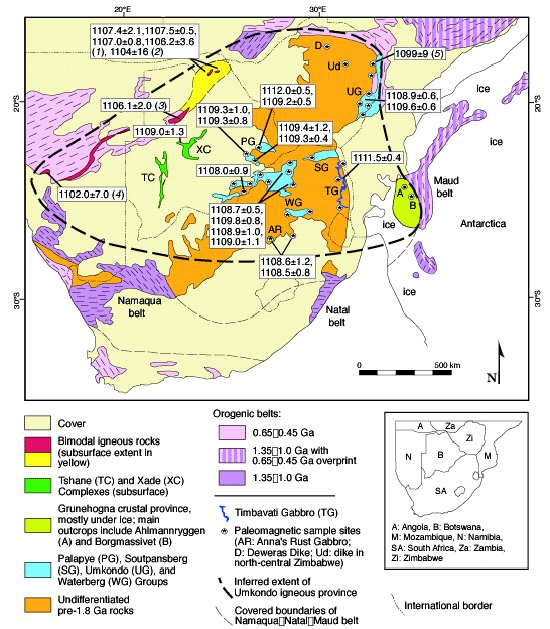
Figure 1: Umkondo igneous province in southern Africa and Antarctica (Hanson et al., 2004), with Antarctica restored to pre-Mesozoic position after Reeves et al. (2002); present-day coordinates are shown for Africa. Precambrian geological framework is from Hanson (2003) and Bauer et al. (2003). U–Pb baddeleyite and zircon ages (in Ma) in boxes are from this paper (Fig. 2) and (1) Singletary et al. (2003), (2) Kampunzu et al. (2000), (3) Schwartz et al. (1996), (4) Pfurr et al. (1991), and (5) Wingate (2001). Most of our ages are from diabase sills intruding the Palapye, Umkondo, and Waterberg Groups. Published ages come primarily from anorogenic rhyolites and associated subsurface intrusions within bimodal assemblages in western Botswana and Namibia. Symbols for paleomagnetic sites in many cases represent multiple sites in different intrusions or lava flows; published and our new pole positions for the Umkondo province are shown in Fig. 3.
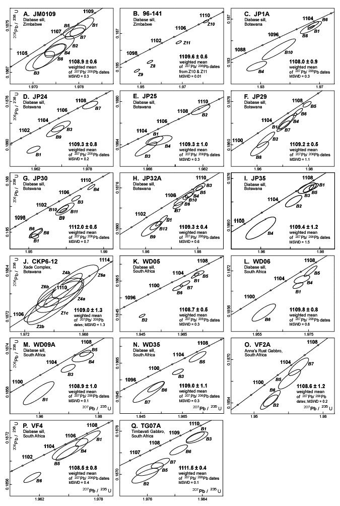
Figure 2: Concordia diagrams for Umkondo mafic intrusions [from Supporting Online Material in Hanson et al. (2004)]. Scale of diagrams is variable. Ages (in Ma) are marked on concordia curves. Individual analyses are depicted as 2_ error ellipses; numbers by analyses correspond to individual baddeleyite (B) or zircon (Z) crystals analyzed. Igneous crystallization ages, indicated in lower right in each diagram (in Ma), are based on weighted mean of 207Pb/206Pb dates for plotted analyses, except for sample 96-141, where age is based on weighted mean of 207Pb/206Pb dates for the two most concordant analyses (Z10 and Z11). MSWD = mean square of weighted deviates.
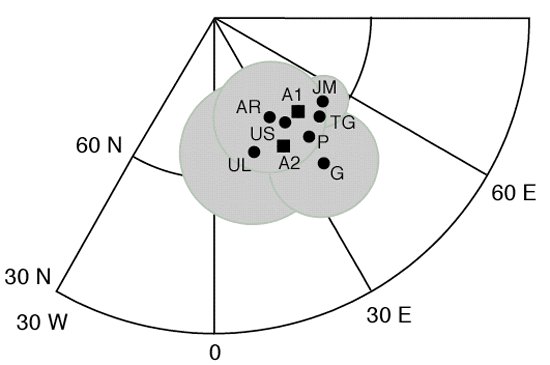
Figure 3: Paleomagnetic poles for members of the Umkondo igneous province [from Supporting Online Material in Hanson et al. (2004)]. All poles have overlapping circles of 95% confidence, which are enclosed in shaded area. Poles from Antarctica are shown as squares. References for poles: A1: lavas and diabase sills, Ahlmannryggen (Peters, 1989), A2: diabase sills, Ahlmannryggen (Jones et al., 2003), AR: Anna's Rust Gabbro, Vredefort dome, South Africa (Allsopp et al., 1989), G: diabase sills, South Africa (this paper), JM: diabase sills, Botswana and South Africa (Jones and McElhinny, 1966), P: diabase sills, Botswana (Pancake, 2001 and this paper), TG: Timbavati Gabbro, South Africa (Hargraves et al., 1994), UL: Umkondo lavas, eastern Zimbabwe (McElhinny, 1966), US: Umkondo diabase sills, eastern Zimbabwe (McElhinny and Opdyke, 1964).
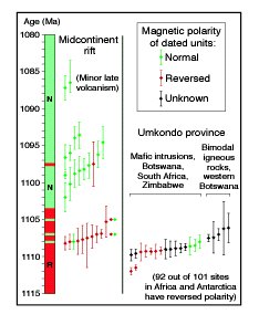
Figure 4: U-Pb zircon and baddeleyite crystallization ages (with 2 sigma error bars, unless not given in original reference) for igneous rocks from Midcontinent rift and Umkondo province (Hanson et al., 2004). Ages with error bars ± 2 Ma from Umkondo province are not shown except for bimodal rocks in western Botswana. Midcontinent rift data are from Van Schmus et al. (1990), Heaman and Machado (1992), Davis and Green (1997), and Zartman et al. (1997). See Figs. 1 and 2 for Umkondo data. Two major polarity chrons for Midcontinent rift are shown to left; main reversal separating them occurred between 1105 ± 2 and 1102 ± 2 Ma (Davis and Green, 1997). Exact ages and total number of short intervals of opposite polarity within main polarity chrons are unknown and are shown schematically. Reversal time scale for Midcontinent rift is based on paleomagnetic data for many more rock units than have been dated.
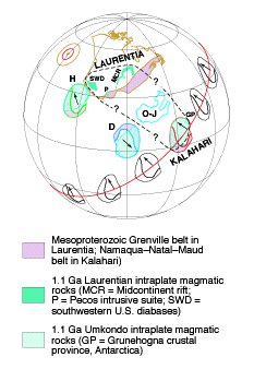
Figure 5: Alternate proposed positions of Kalahari craton relative to Laurentia (Hanson et al., 2004). Laurentia is shown in present-day coordinates; other cratons within Rodinia are not shown. Mean 1108 Ma poles and their 95% circles of confidence for Kalahari (red) and Laurentia (brown) are indicated (see discussion in Hanson et al., 2004). Alignment of mean Umkondo pole with mean pole for coeval rocks of Midcontinent rift permits Kalahari to occupy any position on small circle shown in red (approximately same as paleoequator in this case). Our preferred position for Kalahari is outlined in red, and bold dashed line indicates inferred extent of Umkondo-Laurentia LIP. Other proposed positions for Kalahari are labeled H (Hanson et al., 1998) and D (Dalziel et al., 2000); arrow on craton points north in each case. Outline of Cretaceous Ontong-Java plateau (O-J) is shown for comparison. Laurentian intraplate magmatic rocks include Keweenawan tholeiites and alkaline rocks in Midcontinent rift, diabase sills and locally preserved basalt lavas in southwestern United States, and Pecos intrusive suite in subsurface of west Texas and New Mexico.
References
Allsopp, H. L., Kramers, J. D., Jones, D. L., Erlank, A. J., S. Afr. J. Geol. 92, 11 (1989).
Bauer, W., Thomas, R. J., Jacobs, J., in Proterozoic East Gondwana: Supercontinent Assembly and Breakup, M. Yoshida, B. F. Windley, S. Dasgupta, Eds. (Special Publication 206, Geological Society of London, 2003), pp. 247-269.
Dalziel, I. W. D., Mosher, S., Gahagan, L. M., J. Geol. 108, 499 (2000).
Davis, D. W., Green, J. C., Can. J. Earth Sci. 34, 476 (1997).
Hanson, R. E., in Proterozoic East Gondwana: Supercontinent Assembly and Breakup, M. Yoshida, B. F. Windley, S. Dasgupta, Eds. (Special Publication 206, Geological Society of London, 2003), pp. 427-463.
Hanson, R. E., Martin, M. W., Bowring, S. A., Munyanyiwa, H., Geology 26, 1143 (1998).
Hanson, R. E., Crowley, J. L., Bowring, S. A., Ramezani, J., Gose, W. A., Dalziel, I. W. D., Pancake, J. A., Seidel, E. K., Blenkinsop, T. G., Mukwakwami, J., Science 304, 1126 (2004).
Hargraves, R. B., Hattingh, P. J., Onstott, T. C., S. Afr. J. Geol. 97, 114 (1994).
Heaman, L. M., Machado, N., Contrib. Mineral. Petrol. 110, 289 (1992).
Jones, D. L., McElhinny, M. W., J. Geophys. Res. 71, 543 (1966).
Jones, D. L., Bates, M. P., Li, Z. X., Corner, B., Hodgkinson, G., Tectonophysics 375, 247 (2003).
Kampunzu, A. B., Armstrong, R. A., Modisi, M. P., Mapeo, R. B. M., J. Afr. Earth Sci. 30, 579 (2000).
McElhinny, M. W., Geophys. J. R. Astron. Soc. 10, 375 (1966).
McElhinny, M. W., Opdyke, N. D., J. Geophys. Res. 69, 2465 (1964).
Pancake, J. A., M.S. thesis, Texas Christian University (2001).
Peters, M., Ber. Polarforschung 61, 1 (1989).
Pfurr, N., Ahrendt, H., Hansen, B. T., Weber, K., Communs. Geol. Surv. Namibia 7, 35 (1991).
Reeves, C. V., Sahu, B. K., de Wit, M., J. Afr. Earth Sci. 34, 101 (2002).
Schwartz, M. O., Kwok, Y. Y., Davis, D. W., Akanyang, P., S. Afr. J. Geol. 99, 245 (1996).
Singletary, S. J., Hanson, R. E., Martin, M. W., Crowley, J. L., Bowring, S. A., Key, R. M., Ramokate, L. V., Direng, B. B., and Krol, M. A., Precambrian Res. 121, 47 (2003).
Van Schmus, W. R., Martin, M. W., Sprowl, D. R., Geissman, J., Berendsen, P., Geol. Soc. Am. Abstr. Program 22, A174 (1990).
Wingate, M. T. D., S. Afr. J. Geol. 104, 13 (2001).
Zartman, R. E., Nicholson, S. W., Cannon, W. F., Morey, G. B., Can. J. Earth Sci. 34, 549 (1997).